NCERT Solutions for Class 9 Geography Chapter 3 Drainage
Drainage Class 9 – Given in this post is NCERT Solutions Class 9 Geography Chapter 3 Drainage Important Question Answers. The important questions we have compiled will help the students to brush up on their knowledge about the subject. Students can practice Class 9 Geography important questions to understand the subject better and improve their performance in the board exam. The NCERT Solutions Class 9 Social Science (Geography) provided here will also give students an idea about how to write the answers.
Chapter 3 Drainage MCQ Based Questions
Q1 The city located on the water divide between the Indus and the Ganga river system is ________
A Jabalpur
B Ambala
C Meerut
D Chandigarh
Ans B Ambala
Q2 Which river is called the Dihang when it enters India in Arunachal Pradesh
A The Ganga
B The Brahmaputra
C The Indus
D The Kaveri
Ans B The Brahmaputra
Q3 The world’s largest drainage basin is of the
A Amazon river
B Nile river
C Ganga river
D Hwang Ho river
Ans A Amazon river
Q4 Which one of the following peninsular rivers of India flows west and makes estuaries?
A The Krishna
B The Mahanadi
C The Godavari
D The tapi
Ans D The tapi
Q5 The Vembanad Lake is located in
A Kerala
B Andhra Pradesh
C Tamil Nadu
D Odisha
Ans A Kerala
Q6 Which one of the following lake is artificial?
A Sambhar
B Chilika
C Pulicat
D Rana Pratap sagar
Ans D Rana Pratap sagar
Q7 Which of the peninsular rivers is called the ‘Dakshin Ganga’?
A The Mahanadi
B The Krishna
C Godavari
D The tapi
Ans C Godavari
Q8 The valley of Kashmir is famous for the
A Dal Lake
B Houseboats
C Shikaras
D All of the above
Ans D All of the above
Q9 The Ganga Action Plan (GAP) Phase-I was started in the year:
A 1970
B 1975
C 1980
D 1985
Ans D 1985
Q10 The drainage basin of the Mahanadi is not shared by
A Madhya Pradesh
B Maharashtra
C Chhattisgarh
D Jharkhand
Ans A Madhya Pradesh
Related – Drainage MCQs Question Answers
Q11 Which one of the following describes the drainage patterns resembling the branches of a tree?
A Radial
B Dendrite
C Centrifugal
D Trellis
Ans B Dendrite
Q12 In which of the following states is the Wular lake located?
A Rajasthan
B Uttar Pradesh
C Punjab
D Jammu and Kashmir
Ans D Jammu and Kashmir
Q13 The river Narmada has its source at
A Satpura
B Dal
C Amarkantak
D Gobind Sagar
Ans D Gobind Sagar
Q14 Which one of the following lakes is a salt water lake?
A Sambhar
B Dal
C Wular
D Gobind Sagar
Ans A Sambhar
Q15 Which one of the following is the longest river of the Peninsular India?
A Narmada
B Krishna
C Godavari
D Mahanadi
Ans C Godavari
Q16 Which one amongst the following rivers flows through a rift valley?
A Mahanadi
B Tungabhadra
C Krishna
D Tapi
Ans D Tapi
Q17 TheWainganga and the Penganga are tributaries of which of the following rivers?
A The Mahanadi
B The Narmada
C The Godavari
D The Krishna
Ans C The Godavari
Q18 Which of the following rivers is not a tributary of river Godavari?
A Purna
B Ghatprabha
C Ardha
D Pranhita
Ans B Ghatprabha
Q19 Which of the following rivers rises from the slopes of the Western Ghats in the Nasik district of Maharashtra?
A Mahanadi
B Narmada
C Godavari
D Koyna
Ans C Godavari
Q20 The drainage basin of which of the following rivers covers parts of Karnataka, Kerala and Tamil Nadu?
A Godavari
B Krishna
C Kaveri
D Musi
Ans C Kaveri
Q21 Which of the following rivers originates from the Hazaribagh plateau of Chhota Nagpur region and flows eastwards?
A Amravati
B Bhima
C Ghatprabha
D Damodar
Ans D Damodar
Q22 Which type of lakes contain water only during the rainy season?
A Oxbow lakes
B Lagoons
C Lakes in basins of inland drainage
D Glacial lakes
Ans C Lakes in basins of inland drainage
Q23 Which one of the following lakes is a saltwater lake?
A Wular Lake
B Sambhar Lake
C Barapani Lake
D Dal Lake
Ans B Sambhar Lake
Q24 Which of the following lakes is formed as a result of tectonic activity?
A Wular Lake
B Kolleru Lake
C Loktak Lake
D Dal Lake
Ans A Wular Lake
Q25 Which one of the following is not a lake created by human beings?
A Gobind Sagar
B Nizam Sagar
C Barapani
D Hirakud
Ans C Barapani
Q26 Which of the following states are Nainital and Bhimtal located?
A Jammu and Kashmir
B Himachal Pradesh
C Uttar Pradesh
D Uttarakhand
Ans D Uttarakhand
Q27 Lakes are of great value to human beings. Which of the following statements about lakes given below is incorrect?
A Helps to regulate the flow of rivers
B It results in flooding
C Can be used for developing hydel power
D Enhances natural beauty
Ans B It results in flooding
Q28 Which of the following is not one of the causes of river pollution?
A Dumping of garbage
B Aquatic organisms and algae
C Discharge of untreated sewage
D Discharge of industrial effluents
Ans B Aquatic organisms and algae
Q29 Which of the following is the result of concern over rising pollution in our rivers?
A Banning hydroelectric projects
B Various river action plans
C Rainwater harvesting
D None of the above
Ans B Various river action plans
1 Mark Questions
Q1 Which is the largest river basin in India? (NCERT QUESTION)
Ans The Ganga basin is the largest basin in India.
Q2 Name the two headstreams of the Ganga. Where do they meet to form the Ganga? (NCERT QUESTION)
Ans Alakananda and Bhagirathi are the two headstreams of the Ganga.
They meet at Devprayag.
Q3 Which two Peninsular rivers flow through the trough? (NCERT QUESTION)
Ans Narmada and Tapi are the two Peninsular rivers, which flow through the trough.
Q4 What is a river/drainage basin?
Ans A river/drainage basin is an area drained by a single river system.
Q5 What is a watershed?
Ans An upland/highland area that separates two drainage basin systems.
Q6 Which river has the largest basin in India?
Ans River Ganga has the largest basin in India.
Q7 In which two major groups Indian rivers are divided into?
Ans The Indian rivers are divided into:
- The Himalayan rivers
- The Peninsular rivers
Q8 What is a perennial river?
Ans Perennial rivers have water throughout the year. These rivers get water from rain and snow e.g. River Ganga.
Q9 What is a gorge?
Ans A gorge is a deep narrow channel created by a flowing river.
Q10 What do Himalayan rivers do in their upper course?
Ans The Himalayan rivers perform intensive erosion activity in their upper course and carry huge loads of silt and sand.
Q11 List the factors on which the drainage patterns depend.
Ans The slope of the land, the rock structure as well as the climatic conditions of the area are some factors on which the drainage pattern depends.
Q12 How is the dendritic pattern formed by the river?
Ans The dendritic pattern is formed by the river channel, when the river follows the slope of the land. The stream with its tributaries develops a pattern that resembles the branches of a tree so named as dendritic.
Q13 How does a rectangular pattern of drainage develop?
Ans Rectangular pattern of drainage develops on a strongly jointed rocky’ terrain.
Q14 How does a radial pattern of drainage develop?
Ans Radial pattern develops when streams flow in different directions from a central peak/dome.
Q15 Why are peninsular rivers called seasonal?
Ans The peninsular rivers are called seasonal because their flow depends upon rainfall. Even large rivers like the Narmada have less water during the dry season.
Q16 Where do most of the peninsular rivers originate? Where do they flow?
Ans Most of the peninsular rivers originate from the Western Ghats and they flow into the Bay of Bengal.
Q17 Name three main Himalayan river systems.
Ans The three main Himalayan river systems are the Indus system, the Ganga system and the Brahmaputra system.
Q18 What is a river system?
Ans A river along with its tributaries may be called a river system.
Q19 Where does the Indus river originate?
Ans The Indus river originates in Tibet, near lake Mansarovar.
Q20 Name the tributaries which join the Indus river in Kashmir.
Ans The Zaskar, the Nubra, the Hunza and the Shyok are the tributaries which join the Indus river in Kashmir.
Q21 Which are the main tributaries of River Indus?
Ans The Satluj, the Ravi, the Beas, the Chenab and the Jhelum are the main tributaries of River Indus.
Q22 In which sea River Indus falls into?
Ans River Indus flows into the Arabian Sea.
Q23 What is the total length of River Indus?
Ans The total length of river Indus is 2900 km.
Q24 Write the regulations mentioned in the Indus Water Treaty of 1960
Ans According to the regulations of the Indus Water Treaty of 1960, India can use only 20% of the total water carried by the Indus river system.
Q25 From which place does the River Ganga originate?
Ans The headwaters of the Ganga called the Bhagirathi is fed by Gangotri Glacier and joined by Alaknanda at Devprayag in Uttarakhand.
Q26 Name the main tributaries of River Ganga.
Ans The Yamuna, the Ghaghara, the Gandak and the Kosi are the main tributaries of River Ganga.
Q27 From which place does the Yamuna river originate?
Ans River Yamuna originates from Yamunotri glacier. Being a right bank tributary of Ganga river. It joins the Ganga river at Allahabad.
Q28 Mention the journey/river drainage of River Yamuna.
Ans Starting from the Yamunotri glacier, it flows parallel to the Ganga and as a right bank tributary, meets the Ganga at Allahabad.
Q29 Which rivers rise from Nepal Himalayas?
Ans The Ghaghara, the Gandak and the Kosi rise in the Nepal Himalayas.
Q30 Mention the distinguished features about the Ghaghara, the Gandak and the Kosi river.
Ans 1. These rivers flood the northern plains every year.
- They enrich the soil for agricultural use.
Q31 Which tributaries join Ganga from peninsular uplands?
Ans The Chambal, the Betwa and the Son join the Ganga from the peninsular uplands.
Q32 What is the main feature of the tributaries of Ganga joining from the peninsula?
Ans These tributaries rise from semi-arid areas with shorter courses and do not carry much water.
Q33 What is the Namami Gange Programme?
Ans It is an Integrated Conservation Mission approved as a ‘flagship programme’ by the Union Government in June 2014.
Q34 List the twin objectives of Namami Gange Programme.
Ans Abatement of pollution, conservation and rejuvenation of the national river Ganga.
Q35 Where is the northernmost point of the Ganga delta?
Ans The northernmost point of the Ganges delta is in Farakka, West Bengal.
Q36 Where did Ganga river named as Meghna?
Ans After joining Brahamputra river, Ganga river was named as Meghna.
Q37 How is Sundarban delta formed?
Ans The waters of two very big rivers i.e. the Ganga and the Brahmaputra flows into the Bay of Bengal and the delta formed by these rivers is known as Sundarban delta. It is the world’s largest and fastest growing delta.
Q38 How is the Sundarban delta named?
Ans The Sundarban delta gets its name from the Sundari trees which grow very well in the marshland and does not get rot in water.
Q39 What is the total length of the River Ganga?
Ans The total length of the River Ganga is over 2500 km.
Q40 Which place is located on the water divide of river Ganga and river Indus?
Ans Plains of Ambala is located on the water divide of the Ganga and Indus river.
Q41 How does River Ganga form large meanders?
Ans The plains from Ambala to the Sundarban stretch over nearly 1800 km, but the fall in its slope is hardly 300 meters; there is a fall of one meter for every 6 km. Thus the river develops large meanders.
Q42 From where does Brahmaputra river originate?
Ans The Brahmaputra river originates in Tibet, east of Mansarovar lake very close to the sources of the Indus and the Satluj.
Q43 From where Brahmaputra river enters India?
Ans On reaching the Namcha Barwa (7757m), it takes a U-turn and enters India in Arunachal Pradesh through a gorge.
Q44 When is the Brahmaputra river known as Dihang?
Ans When Brahmaputra river enters India, it is known as Dihang.
Q45 What is Brahmaputra called in Tibet and Bangladesh?
Ans Brahmaputra is called TsangPo in Tibet and Jamuna in Bangladesh.
Q46 Why does River Brahmaputra carry less water and silt in Tibet?
Ans In Tibet, River Brahmaputra carries less water and silt as it is a dry and cold area.
Q47 Give one feature of River Brahmaputra.
Ans The Brahmaputra river is a braided channel in its entire length in Assam and forms many riverine islands, e.g. Majuli in Brahmaputra, is the largest inhabited riverine island in the world.
Q48 Mention the cause behind widespread devastation caused by Brahmaputra river.
Ans Due to floods in Assam and Bangladesh during the rainy season, every year Brahmaputra river overflows its banks and causes widespread devastation.
Q49 How is Brahmaputra river different from other north Indian rivers?
Ans Unlike other north Indian rivers, the Brahmaputra river has huge deposits of silt on its bed which results in rising of river bed. The river also shifts its channel frequently.
Q50 Name the main water divide in Peninsular India.
Ans The main water divide in Peninsular India is formed by the Western Ghats.
Q51 Name the major peninsular rivers of India.
Ans The Mahanadi, the Godavari, the Krishna and the Kaveri are the major peninsular rivers in India.
Q52 Name the peninsular rivers flowing westwards and also make estuaries.
Ans The Narmada and the Tapi are the peninsular rivers flow westwards and also make estuaries.
Q53 From which place Narmada river rises?
Ans The Narmada river rises in Amarkantak hills in Madhya Pradesh.
Q54 Mention some picturesque location of Narmada river when the Narmada river flows through.
Ans The Marble rocks near Jabalpur and the Dhuadhar forms a picturesque location.
Q55 Name the scheme undertaken by the government of Madhya Pradesh for the Narmada river conservation mission.
Ans Namami Devi Narmade.
Q56 In which Indian states is Narmada basin formed?
Ans Narmada basin is formed in Madhya Pradesh and Gujarat.
Q57 Where does the River Tapi rise?
Ans The River Tapi rises in Satpura ranges in the Betul district of Madhya Pradesh.
Q58 Name the Indian states which cover parts of Tapi basin.
Ans Madhya Pradesh, Gujarat and Maharashtra are the states which cover the Tapi basin.
Q59 Why coastal rivers are short in length?
Ans Coastal rivers are short in length because the coastal plains between the Western Ghats and the Arabian Sea are very narrow.
Q60 Name the major west-flowing rivers of the Western Ghats.
Ans Sabarmati, Mahi, Bharathpuzha and Periyar are the major west flowing rivers of the Western Ghats.
Q61 Which is the largest Peninsular river?
Ans River Godavari is the largest Peninsular river.
Q62 Where does the River Godavari rise?
Ans The River Godavari rises from the slopes of the Western Ghat in the Nasik district of Maharashtra.
Q63 Which drainage basin is largest among Peninsular rivers?
Ans Godavari drainage basin is largest among the Peninsular rivers.
Q64 Name the tributaries of River Godavari.
Ans The Purna, the Wardha, the Pranhita, the Manjra, the Wainganga and the Penganga are the tributaries of River Godavari.
Q65 Which river is known as Dakshin Ganga?
Ans Godavari river is known as Dakshin Ganga.
Q66 From where does the Mahanadi river rises?
Ans Mahanadi river rises in the highlands of Chhattisgarh.
Q67 Write the total length of Mahanadi river? Which Indian states have the Mahanadi river basin?
Ans The total length of river is 860 km. Maharashtra, Chhattisgarh, Jharkhand and Odisha have Mahanadi river basin.
Q68 From which region does River Krishna rise?
Ans River Krishna rises from a spring near Mahabaleshwar.
Q69 Mention the length of Krishna river. Which waterbody does it fall into?
Ans The total length of Krishna river is 1400 km and it falls into the Bay of Bengal.
Q70 Name the major tributaries of River Krishna.
Ans The Tungabhadra, the Koyana, the Ghatprabha, the Musi and the Bhima are the major tributaries of River Krishna.
Q71 Which Indian states share the basin of Krishna river?
Ans Maharashtra, Karnataka and Andhra Pradesh are the Indian states which shared the Krishna basin.
Q72 Write the main tributaries of Kaveri river. Also mention its total length.
Ans Kaveri basin’s main tributaries are Amravati, Bhavani, Hemavati and Kabini. Its total length is 760 km.
Q73 Name the Indian states which have Kaveri basin.
Ans Karnataka, Kerala and Tamil Nadu have the Kaveri basin.
Q74 Name the second biggest waterfall in India which is made by River Kaveri.
Ans The second biggest waterfall in India which is made by River Kaveri is Jog Falls, it is used to generate hydroelectricity.
Q75 Name the biggest waterfall in India.
Ans Kunchikal falls (1493 feet/455 mts)
Q76 Mention the composition of water on earth’s surface.
Ans 71% of the earth’s surface is covered with water. 97% of it is salt water and only 3% is in the form of freshwater in rivers, lakes, ponds, glaciers and ice caps.
Q77 How are oxbow lakes formed?
Ans A meandering river cuts across the narrow neck of the meander forming an oxbow lake.
Q78 How do lakes become seasonal?
Ans Lakes in the region of inland drainage are sometimes seasonal, e.g. Sambhar lake of Rajasthan.
Q79 What are freshwater lakes?
Ans Freshwater lakes are mostly found in the Himalayan region. These are usually formed by a glacier and get filled with water by melting snow.
Q80 Name some fresh water lakes of India.
Ans The Wular, Dal, Bhimtal, Nainital, Loktak and Barapani are some freshwater lakes.
Q81 How are man-made lakes formed?
Ans Man-made lakes are formed when the rivers are used for generation of hydro-electricity by constructing a dam across a river. e.g. Guru Gobind Sagar lake (Bhakra Nangal Dam Project).
Q82 Give the full form of GAP & NRCP.
Ans GAP is Ganga Action Plan and NRCP is National River Conservation Plan.
Q83 When was the Ganga Action Plan launched?
Ans 1985.
Q84 Under which plan the Ganga Action Plan was expanded to cover other rivers in 1995?
Ans National River Conservation Plan.
Q85 What is the objective of the NRCP?
Ans To improve the water quality of the rivers through the implementation of pollution abatement work.
Assertion-reason based questions:
Q1 Assertion (A): The Narmada and the Tapi are west flowing rivers and drains into the Arabian sea.
Reason (R): Tilting of the peninsular block from southeast to the northwest direction.
Options:
- Both A and R are true and R is the correct explanation of A.
- Both A and R are true but R is not the correct explanation of A.
- A is true but R is false.
- A is false but R is true.
Ans C. A is true but R is false.
The Peninsular drainage system is governed by many factors. Amongst them is the slight tilting of the peninsular block from northwest to southeast direction which gives the orientation to the entire drainage system towards Bay of Bengal. That is why many rivers like Krishna, Godavari, Cauvery drain towards the Bay of Bengal. Reason is incorrect: But the Narmada and the Tapi are exceptions as they flow west, towards the Arabian sea. Direction of their flow is not governed by the tilting of the peninsular block as they flow through rift valleys which are formed due to multiple subsidence and upliftment of the Earth’s surfaces. Narmada’s course is defined by the Son-Narmada Fault (NSF), which divides the Indian landmass into the peninsular block of the south and a northern foreland block. Moreover, the Peninsular block is tilted slightly eastwards.
Q2 Assertion (A): Most of the peninsular rivers drain into the Bay of Bengal.
Reason (R): The peninsular plateau is sloping eastwards.
Options:
- Both A and R are true and R is the correct explanation of A.
- Both A and R are true but R is not the correct explanation of A.
- A is true but R is false.
- A is false but R is true.
Ans A. Both A and R are true and R is the correct explanation of A.
Deccan, the entire southern peninsula of India south of the Narmada River, marked centrally by a high triangular tableland. The Deccan’s average elevation is about 2,000 feet (600 meters), sloping generally eastward. Its principal rivers—the Godavari, Krishna, and Kaveri (Cauvery)—flow from the Western Ghats eastward to the Bay of Bengal. Reason is true and corr:ect explanation of Assertion: The pattern of flow of peninsular rivers from west to east proves that the general elevation of the plateau is from the west to the east.
Q3 Assertion (A): An upland drainage basin is called water divide.
Reason (R): Any elevated area separates the basin forming two drainage basins.
Options:
- Both A and R are true and R is the correct explanation of A.
- Both A and R are true but R is not the correct explanation of A.
- A is true but R is false.
- A is false but R is true.
Ans A. Both A and R are true and R is the correct explanation of A.
Q4 Assertion (A): Most of the HImalayan rivers are perennial.
Reason (R): Perennial rivers receive water from rains as well as from melted snow from the lofty mountains.
Options:
- Both A and R are true and R is the correct explanation of A.
- Both A and R are true but R is not the correct explanation of A.
- A is true but R is false.
- A is false but R is true.
Ans A. Both A and R are true and R is the correct explanation of A.
Q5 Assertion (A): The peninsular rivers have shorter and shallow courses.
Reason (R): Some of the peninsular rivers originate in the central highlands and flow towards the west.
Options:
- Both A and R are true and R is the correct explanation of A.
- Both A and R are true but R is not the correct explanation of A.
- A is true but R is false.
- A is false but R is true.
Ans B. Both A and R are true but R is not the correct explanation of A.
A large number of peninsular rivers are seasonal as their flow is dependent on rainfall.
Q6 Assertion (A): In Tibet, Brahmaputra river carries a smaller volume of water.
Reason (R): Brahmaputra river is seasonal river.
Options:
- Both A and R are true and R is the correct explanation of A.
- Both A and R are true but R is not the correct explanation of A.
- A is true but R is false.
- A is false but R is true.
Ans C. A is true but R is false.
The Brahmaputra river carries less water in Tibet as Tibet is a dry and cold region.
Q7 Assertion (A): Godavari is known as dakshin Ganga.
Reason (R): It rises from the slopes of the Western Ghats in the Nashik district of Maharashtra and drains into the bay of Bengal.
Options:
- Both A and R are true and R is the correct explanation of A.
- Both A and R are true but R is not the correct explanation of A.
- A is true but R is false.
- A is false but R is true.
Ans B. Both A and R are true but R is not the correct explanation of A.
Because of its length and the area it covers it is known as dakshin ganga.
Q8 Assertion (A): Guru Govind Sagar Lake is formed due to human activities.
Reason (R): Damming of river for the generation of hydel power led to the formation of this lake.
Options:
- Both A and R are true and R is the correct explanation of A.
- Both A and R are true but R is not the correct explanation of A.
- A is true but R is false.
- A is false but R is true.
Ans A. Both A and R are true and R is the correct explanation of A.
Q9 Assertion (A): The Caspian, the Dead, the Aral sea are lakes.
Reason (R): Lakes of larger extent are called the seas.
Options:
- Both A and R are true and R is the correct explanation of A.
- Both A and R are true but R is not the correct explanation of A.
- A is true but R is false.
- A is false but R is true.
Ans A. Both A and R are true and R is the correct explanation of A.
Fill in the blanks in the following:
Q1 River ________ has the largest basin in India.
Ans Ganga
Q2 According to the regulations of the __________, India can use only 20% of the total water carried by the Indus river system.
Ans Indus Water Treaty of 1960
Q3 The Ghaghara, the Gandak and the Kosi rise in the ______________.
Ans Nepal Himalayas
Q4 After joining Brahamputra river, Ganga river was named as ____________.
Ans Meghna
Q5 The waters of two very big rivers i.e. the Ganga and the Brahmaputra flows into the Bay of Bengal and the delta formed by these rivers is known as ___________ delta.
Ans Sundarban
Q6 The northernmost point of the Ganges delta is in ____________.
Ans Farakka, West Bengal
Q7 When Brahmaputra river enters India, it is known as _________.
Ans Dihang
Q8 The River _________ rises in Satpura ranges in the Betul district of Madhya Pradesh.
Ans Tapi
Q9 _________ drainage basin is largest among the Peninsular rivers.
Ans Godavari
Q10 River Krishna rises from a spring near ______________.
Ans Mahabaleshwar
Q11 The Tungabhadra, the Koyana, the Ghatprabha, the Musi and the Bhima are the major tributaries of the River _________.
Ans Krishna
Q12 Karnataka, Kerala and Tamil Nadu have the _________ basin.
Ans Kaveri
Q13 A meandering river cuts across the narrow neck of the meander forming an ___________.
Ans oxbow lake
Q14 Full form of NRCP is __________.
Ans National River Conservation Plan
Q15 The Wular, Dal, Bhimtal, Nainital, Loktak and Barapani are ____________ lakes.
Ans freshwater
2 Mark Questions
Q1 What is meant by the water divide? Give an example. (NCERT QUESTION)
Ans Any elevated area, such as a mountain or upland, separates two drainage basins. Such upland is known as the water divide. Ambala is located on the water divide between the Indus and the Ganga river systems.
Q2 Where do the rivers Indus and Ganga have their origin? (NCERT QUESTION)
Ans The headwaters of the Ganga called the ‘Bhagirathi’ is fed by the Gangotri Glacier and joined by the Alaknanda at Devprayag in Uttaranchal. At Haridwar, the Ganga emerges from the mountains onto the plains. The Indus flows through Baltistan and Gilgit and emerges from the mountains at Attock.
Q3 Why does the Brahmaputra in its Tibetan part have less silt, despite a longer course? (NCERT QUESTION)
Ans The Brahmaputra river, which is known as Tsangpo in Tibet, receives a very little volume of water in Tibet so it has less silt there. On the other hand, this very river enters India and passes through such a region which receives heavy rainfall. As such in India, it carries a large volume of water and a larger amount of silt.
Q4 Mention any two features of the Himalayan rivers.
Ans The two features of the Himalayan rivers are:
- The Himalayan rivers are long.
- They are joined by many large and important tributaries.
Q5 Which two rivers form the largest delta? Write any two features of this delta.
Ans River Ganga and River Brahmaputra from the largest delta i.e. the Sundarban delta. The two features of this delta are:
- It is the largest and fastest growing delta in the world.
- It gets its name as Sundarban from the Sundari tree. It is the home of the Royal Bengal tiger.
3 Mark Questions
Q1 Discuss the significant difference between the Himalayan and the Peninsular rivers. (NCERT QUESTION)
Ans
| The Himalayan Rivers | The Peninsular or Deccan Rivers |
| 1. The Himalayan rivers rise in the snow-covered mountains as such they flow throughout the year. | 1. The mountains in which the Deccan rivers rise are not snow-covered. Hence they dry up in summer. |
| 2. The Himalayan rivers flow in leveled Northern Plains. Therefore, they are quite useful for navigation and irrigation. | 2. The Peninsular rivers flow on the uneven rocky surface. Therefore they are neither navigable nor useful for irrigation. |
| 3. The Himalayan rivers bring with them fertile alluvium which they deposit in the Indo-Gangetic Plains. | 3. The Peninsular rivers do not bring with them enough alluvium. As the current is swift so the deposition activity is negligible. |
Q2 Compare the east-flowing and the west-flowing rivers of the Peninsular plateau. (NCERT QUESTION)
Ans
| East Flowing Rivers | West Flowing Rivers |
| 1. The Mahanadi, the Godavari, the Krishna, and the Kaveri are the main east flowing rivers of Peninsular India. | 1. The Narmada and the Tapi are the main west-flowing rivers of Peninsular India. |
| 2. These rivers drain in the Bay of Bengal. | 2. These rivers drain in the Arabian Sea. |
| 3. These rivers make deltas at their mouths. | 3. These rivers enter the sea through estuaries. |
Q3 Why are rivers important for the country’s economy? (NCERT QUESTION)
Ans 1. Rivers have been of fundamental importance throughout human history.
- Water from the rivers is a basic natural resource, essential for various human activities. Therefore, the riverbanks have attracted settlers from ancient times. These settlements have now become big cities. Make a list of cities in your state, which is located on the bank of a river.
- Using rivers for irrigation, navigation, hydropower generation is of special significance – particularly to a country like India, where agriculture is the major source of livelihood of the majority of its population.
Q4 Explain any three features of Peninsular rivers.
Ans The three features of the Peninsular rivers are:
- A large number of peninsular rivers are seasonal as they are dependent on rainfall.
- They have short and shallow courses.
- Most of the peninsular rivers originate from the Western Ghats and flow into the Bay of Bengal.
- The drainage basin of Peninsular rivers are small in size.
Q5 Why are Peninsular rivers seasonal in nature? State any three reasons.
Ans The three reasons are as follows:
- The Peninsular rivers are dependent on rainfall unlike the Himalayan rivers which are snowfed.
- The hills of the peninsular plateau are not snow-bound unlike the Himalayas.
- These rivers follow a smaller course and have small basins which influence water volume.
- The catchment areas (the area where the river gets maximum water either by rain/snow) of peninsular rivers are small in comparison to Himalayan rivers.
Q6 Compare a delta and an Estuary.
Ans
| Delta | Estuary |
| 1. It is a triangular-shaped alluvial landmass formed at the mouth of the river. | 1. Deep funnel-shaped valleys at the mouth of a river where the sea water and the river water meets. It is free from any deposits. |
| 2. Delta is formed in regions of low tides by a dense network of distributaries in the coastal areas. | 2. Estuaries are formed in areas of high tides and rift valleys. |
| 3. The delta areas have fertile soils which get renewed annually. | 3. These are the best fishing grounds of the world. |
| 4. e.g. Sundarban delta in India and Bangladesh. | 4. e.g. Estuaries of the Narmada and Tapi river. |
Q7 Explain the concept of water divide with special reference for Ganga and Indus river systems. Name the major distributary of river Ganga.
Ans 1. A water divide is a highland area/an upland/mountain which separates two drainage basins.
- Ambala is located on the water divide between the Indus and the Ganga river system.
- The distributary of River Ganga is RIver Hooghly.
Q8 Why are most of the Peninsular river draining into the Bay of Bengal? Give two reasons. Name two rivers draining into the Arabian Sea.
Ans 1. Most of the Peninsular rivers drain into the Bay of Bengal because of the following reasons:
(a) The Eastern Ghats are lower than the Western Ghats and are also discontinuous thus making it easier for the rivers to reach the Bay of Bengal.
(b) The Deccan Plateau has a gentle slope towards the east, thus the rivers drain towards the east.
- Two rivers draining into the Arabian Sea are the Narmada and the Tapi.
Q9 Describe three important features of the Tapi basin.
Ans The important features of Tapi basin are:
- The Tapi river rises in the Satpura ranges in the Betul district of Madhya Pradesh.
- It also flows through a rift valley parallel to the Narmada but much shorter in length.
- Its basin covers parts of Madhya Pradesh, Gujarat and Maharashtra.
Q10 Why are the rivers of Western Coast very short?
Ans The rivers of West Coast of India are very short because:
- The coastal plains between Western Ghats and the Arabian Sea are very narrow.
- The course of these rivers are short as they do not have much water and drain small area of the states.
- These rivers are seasonal in nature. Examples of these rivers are Sabarmati that drains parts of Rajasthan and Gujarat; Mahi – Madhya Pradesh, Rajasthan, Gujarat; Periyar – Kerala, Bharathpuzha – Kerala.
Q11 Describe any three important features of the Mahanadi basin.
Ans The three important features of Mahanadi basin are:
- Mahanadi basin covers parts of the states of Chhattisgarh, Jharkhand, Odisha and Maharashtra.
- It rises in the highlands of Chhattisgarh and flows through Odisha to form a delta in the Bay of Bengal. It’s length is 860 km.
- Due to the devastating floods that the river causes every year, the Hirakund dam has been built on it.
Q12 From where does the River Krishna originate? Name its tributaries. Mention the names of the states covered by it.
Ans 1. The River Krishna rises from a spring near Mahabaleshwar.
- Its tributaries are the Tungabhadra, the Koyana, the Ghatprabha, the Musi and the Bhima.
- The states covered by Krishna river are Maharashtra, Karnataka and Andhra Pradesh.
Q13 What is the difference between a Tributary and Distributary?
Ans
| Tributary | Distributary |
| 1. A small stream which joins the main river. | 1. A branch of the main river which leaves the main river before it reaches the sea. |
| 2. It adds water to the main river. | 2. It takes away the water of the main river and adds it to the sea. |
| 3. Main river gains water and becomes an active agent of gradation. | 3. The river becomes sluggish when the distributary leaves it. |
| 4. e.g. Yamuna, Ghaghara, Gandak and Kosi are tributaries of Ganga river. | 4. e.g. Hooghly is a distributary of Ganga. |
Q14 (a) How are the freshwater lakes formed in the Himalayas? Give two examples of freshwater lakes in this region.
(b) How is the Sambhar lake useful?
Ans (a) 1. Most of the freshwater lakes in the Himalayan region are of glacial origin i.e. they are formed when a glacier digs out a basin that is later filled with water from snow melt or rain. Some examples of freshwater lakes are Bhimtal, Nainital, Dal lake etc.
- India’s largest fresh water lake is Wular Lake which is an exception as it was formed by tectonic activity.
(b) Sambhar lake in Rajasthan is a rich source of salt in India.
4 Mark Questions
Q1 Read the extract given below and answer the questions that follow:
The drainage system of India is mainly controlled by the broad relief features of the subcontinent. Accordingly, the Indian rivers are divided into two major groups: the Himalayan rivers; and the Peninsular rivers. Apart from originating from the two major physiographic regions of India, the Himalayan and the Peninsular rivers are different from each other in many ways. Most of the Himalayan rivers are perennial. It means that they have water throughout the year. These rivers receive water from rain as well as from melted snow from the loft mountains. The two major Himalayan rivers, the Indus and the Brahmaputra originate from the North of the mountain ranges. They have cut through the mountains making gorges. The Himalayan rivers have long courses from their source to the sea. They perform an intensive erosional activity in their upper courses from their source to the sea. They perform an intensive erosional activity in their upper courses and carry huge loads of silt and sand. In the middle and the lower courses, these rivers form meanders, oxbow lakes, and many other depositional features in their flood plains. They also have well-developed deltas.
- Which of the following is not the Himalayan river?
A Godavari
B Indus
C Ganga
D Brahmaputra Show
Ans A Godavari
- Which of the following is not the feature of the Himalayan rivers?
A Some Himalayan rivers originate from the North of the mountain range.
B The Himalayan rivers have shorter and shallower courses.
C Brahmaputra is the example of Himalayan rivers.
D None of the above
Ans B The Himalayan rivers have shorter and shallower courses.
- Why do some Himalayan rivers perform intensive erosional activity? Identify the best suitable options.
A Because they originate from high altitude.
B These are small rivers.
C These rivers flow from West to East.
D These rivers are non-perennial.
Ans A Because they originate from high altitude.
- Himalayan rivers have well developed deltas. Which among the following is the prominent cause?
A Himalayan rivers have long courses from their source to sea.
B They flow from the mountain and carry huge loads of silt and sand.
C They flow with a high density of water.
D All of the above
Ans D All of the above
Q2 Read the extract given below and answer the questions that follow:
The river Indus rises in Tibet, near Lake Mansarovar. Flowing west, it enters India in the Ladakh district of Jammu and Kashmir. It forms a picturesque gorge in this part. Several tributaries, the Zaskar, the Nubra, the Shyok and the Hunza, join it in the Kashmir region. The Indus flows through Baltistan and Gilgit and emerges from the mountains at Attock. The Satluj, the Beas, the Ravi, the Chenab and the Jhelum join together to enter the Indus near Mithankot in Pakistan. Beyond this, the Indus flows southwards eventually reaching the Arabian Sea, east of Karachi. The Indus plain has a very gentle slope. With a total length of 2900 km, the Indus is one of the longest rivers of the world. A little over a third of the Indus basin is located in India in the states of Jammu and Kashmir, Himachal Pradesh and the Punjab and the rest is in Pakistan.
- Where does the river Indus originate?
Ans The river Indus rises in Tibet, near Lake Mansarovar.
- Name some tributaries of the Indus.
Ans The Zaskar, the Nubra, the Shyok and the Hunza are some tributaries of the Indus.
- The total length of Indus is __________.
Ans 2900 km
- What all areas does Indus cover?
Ans A little over a third of the Indus basin is located in India in the states of Jammu and Kashmir, Himachal Pradesh and the Punjab and the rest is in Pakistan.
Q3 Read the extract given below and answer the questions that follow:
You may be familiar with the valley of Kashmir and the famous Dal Lake, the houseboats and shikaras, which attract thousands of tourists every year. Similarly, you may have visited some other tourist spot near a lake and enjoyed boating, swimming and other water games. Imagine that if Srinagar, Nainital and other tourist places did not have a lake would they have been as attractive as they are today? Have you ever tried to know the importance of lakes in making a place attractive to tourists? Apart from attraction for tourists lakes are also useful to human beings in many ways. India has many lakes. These differ from each other in the size, and other characteristics. Most lakes are permanent; some contain water only during the rainy season, like the lakes in the basins of inland drainage of semi-arid regions. There are some of the lakes which are the result of the action of glaciers and ice sheets, while the others have been formed by wind, river action, and human activities. A meandering river across a floodplain forms cut-offs that later develop into ox-bow lakes. Spits and bars form lagoons in the coastal areas, e.g. the Chilika lake, the Pulicat lake, the Kolleru lake. Lakes in the region of inland drainage are sometimes seasonal; for example, the Sambhar lake in Rajasthan, which is a salt water lake. Its water is used for producing salt. Most of the freshwater lakes are in the Himalayan region. They are of glacial origin. In other words, they formed when glaciers dug out a basin, which was later filled with snowmelt. The Wular lake in Jammu and Kashmir, in contrast, is the result of tectonic activity. It is the largest freshwater lake in India. The Dal lake, Bhimtal, Nainital, Loktak and Barapani are some other important freshwater lakes. Apart from natural lakes, the damming of the rivers for the generation of hydel power has also led to the formation of Lakes such as Guru Gobind Sagar (Bhakra Nangal Project).
- What attracts thousands of tourists every year to Kashmir?
Ans The valley of Kashmir and the famous Dal Lake, the houseboats and shikaras attract thousands of tourists every year.
- How are ox-bow lakes formed?
Ans A meandering river across a floodplain forms cut-offs that later develop into ox-bow lakes.
- Give an example of a salt water lake.
Ans The Sambhar lake in Rajasthan is a salt water lake.
- Give examples of freshwater lakes.
Ans The Dal lake, Bhimtal, Nainital, Loktak and Barapani are some other important freshwater lakes.
5 Mark Questions
Q1 What is a river pattern? Name any four patterns formed by the rivers.
Ans The streams within the drainage basin form certain patterns depending on
- the slope of the land
- underlying rock structure of the area
- the climate of the area.
The different drainage patterns are:
- Dendritic Pattern: It develops where the river channel follows the slope of the land. When the stream and its tributaries’ drainage pattern resembles the branches of a tree, it is called dendritic.
- Trellis Pattern: This pattern develops when a river is joined by its tributaries at approximately right angles. It also develops when the hard and soft rocks exist parallel to each other.
- Rectangular Pattern: This drainage pattern develops on a strongly jointed rocks terrain.
- Radial Pattern: The drainage pattern develops when streams flow in different directions from a central peak or dome-like structure.
Q2 Write main features of River Indus under the following headings:
- Source
- Tributaries
- Areas drained
- Extent of Indus Plain
- Indus Water Treaty.
Ans The main features of River Indus as an important river of the Himalayas are:
- Source: Indus river rises in Tibet, near lake Mansarovar. While flowing towards west it enters India in the Ladakh district of Jammu and Kashmir by forming a picturesque gorge.
- Tributaries: Several tributaries like the Zaskar, the Nubra, the Shyok and the Hunza join it in the Kashmir region. Other major tributaries are the Satluj, the Beas, the Ravi, the Chenab and the Jhelum join together and form the Indus at Mithankot in Pakistan.
- Areas drained by river Indus: The Indus flows southwards eventually reaching the Arabian Sea east of Karachi areas. This is where the Indus river ends but not the total area drained.
- Extent of the Indus Plain: The Indus plain has a gentle slope. It covers the states of Jammu and Kashmir, Himachal Pradesh and Punjab.
- Indus Water Treaty (1960): According to the regulations of this treaty, India can use only 20% of the total water carried by the Indus river system. The water is used for irrigation in Punjab, Haryana and southern and western parts of Rajasthan.
Q3 Give main characteristic features of the Ganga river system.
Ans The main characteristic features of the Ganga river system are:
- The Ganga rises in Gangotri Glacier in Uttarakhand. Its headstream Bhagirathi joins the Alaknanda at Devprayag in Uttarakhand.
- At Haridwar, the river Ganga comes out from the mountains to the plains.
- Its tributaries like the Yamuna, the Gandak, the Ghaghara, the Kosi flood parts of northern plains every year, causing widespread damage to life and property but the flood enriches the soil naturally. The soil is most suitable for intensive cultivation.
- The main tributaries that join Ganga river from peninsular India are the Chambal, the Betwa and the Son.
- The Ganga continues to flow eastwards after addition of water by its tributaries till Farakka in West Bengal. It then enters Bangladesh and joins Brahamputra and is known as stream Meghna which flows into the Bay of Bengal. Here, it forms the Sundarban delta, which is the largest delta of the world.
Q4 Give characteristic features of the Ganga-Brahmaputra delta.
Ans The characteristic features of the Ganga-Brahmaputra delta are:
- The Ganga-Brahmaputra delta is also known as Ganga delta or Sundarban delta.
- It is situated in Bangladesh (southern parts) and in the state of West Bengal (India).
- It is the world’s largest and fastest growing delta.
- The mainstream of Ganga river flows southwards into Bangladesh and is joined by the Brahmaputra river resulting in the formation of a delta.
- Sundarban delta derived its name from Sundari trees which do not rot in stagnant water.
- It is also the home of Royal Bengal tigers.
Q5 Give the main characteristic features of the mighty Brahmaputra river.
Ans The main characteristics features of Brahmaputra river are:
- Its source lies in Tibet, east of Mansarovar lake very close to the sources of the Indus and the Satluj. It is slightly longer than the Indus and most of its course lies outside India.
- The river carries less silt and smaller volume of water in Tibet as it is a cold and dry area,
- Brahmaputra river passes through a region of high rainfall in India. Hence, the river carries a large volume of water and a considerable amount of silt.
- The Brahmaputra has a braided channel in its entire length in Assam and forms many riverine islands. For example, Majuli island is the largest inhabited riverine island in the world.
- Unlike other rivers of north India, river Brahmaputra is marked by huge deposits of silt on its bed causing the river bed to rise. The river also shifts its channel frequently. Every year during the rainy season the river overflows its banks causing widespread devastation due to floods in Assam and Bangladesh.
Q6 Enlist the characteristic features of the Godavari basin.
Ans The characteristic features of the Godavari basin are as follows:
- It is the largest river basin of the Peninsular rivers.
- It rises in the Nasik district of Maharashtra and joins the Bay of Bengal in Andhra Pradesh.
- The Godavari river basin covers the states of Maharashtra, Madhya Pradesh, Odisha and Andhra Pradesh (50% of this basin covers the state of Maharashtra).
- The Godavari is often referred to as the Dakshin Ganga because of its largest size and extent.
- The important tributaries of River Godavari are: the Purna, the Wardha, the Pranhita, the Manjra, the Wainganga and the Penganga.
Q7 What is meant by drainage? Explain any four benefits of rivers.
Ans 1. Drainage means the river system of an area.
- The four benefits of rivers are:
(i) The rivers provide water, the basic natural resource essential for various human activities.
(ii) The banks of the rivers have always attracted settlers from ancient times. These settlements are now big cities.
(iii) River waters are used for irrigation, navigation, hydro-electric power generation is of special significance.
(iv) Rivers are very significant for countries like India where agriculture is the livelihood of the majority of the population.
Q8 What are the causes of river pollution? How can it be prevented?
Ans River pollution is caused by the following ways:
- Rivers are polluted by domestic, municipal, industrial and agricultural waste. This affects the quality of water.
- Large amounts of untreated sewage are dumped into the rivers. This affects the self cleansing capacity of water.
- Increasing pollution by urbanization and industrialisation also contribute to river pollution which has increased to very high levels.
River pollution can be prevented by:
- Treatment of industrial and urban waste before it is dumped into the rivers.
- Sensitizing the people about pollution of rivers and difficulties in cleaning water.
- Various action plans like Ganga Action Plan to clean up River Ganga.
- Emphasizing on the technologies used to reduce river pollution by promoting recycling of water, improvement of water quality.
Map Based Questions
Q1 On the map of India, mark the major rivers and lakes using appropriate symbols.
Ans
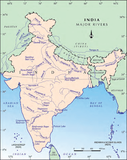
Image Credit: NCERT Textbook
Also See :
Geography Important Questions
- India Size and Location Class 9 Geography Chapter 1 MCQs, Question Answers
- Physical Features of India Class 9 Geography Chapter 2 MCQs, Question Answers
- Climate Class 9 Geography Chapter 4 MCQs, Question Answers
- Natural Vegetation and Wildlife Class 9 Geography Chapter 5 MCQs, Question Answers
History Important Questions
- The French Revolution Class 9 Chapter 1 Notes, MCQs, Question Answers
- Socialism in Europe and The Russian Revolution Class 9 Chapter 2 Notes, MCQs, Question Answers
- Nazism and The Rise of Hitler Class 9 Chapter 3 Notes, MCQs, Question Answers
- Forest Society and Colonialism Class 9 Chapter 4 Notes, MCQs, Question Answers/a>
- Pastoralists in The Modern World Class 9 Chapter 5 Notes, MCQs, Question Answers
Political Science Important Questions
- What is Democracy? Why Democracy Class 9 Chapter 1 Notes, MCQs, Question Answers
- Constitutional Design Class 9 Chapter 2 Notes, MCQs, Question Answers
- Electoral Politics Class 9 Chapter 3 Notes, MCQs, Question Answers
- Working of Institutions Class 9 Chapter 4 Notes, MCQs, Question Answers
- Democratic Rights Class 9 Chapter 5 Notes, MCQs, Question Answers