Class 9 Geography Chapter 2 Physical Features of India Question Answers – Important Questions, Extra Questions
Physical Features of India Class 9 – Given in this post are Class 9 Geography Chapter 2 Physical Features of India Important Question Answers. The important questions we have compiled will help the students to brush up on their knowledge about the subject. Students can practice Class 9 Geography important questions to understand the subject better and improve their performance in the board exam.There are many extra questions also which we have compiled that are based on previous years question papers.
Chapter 2 Physical Features of India MCQ Based Questions
Q1 India has which type of landform?
A Mountains, plateaus
B Plains, islands
C Deserts
D All of these
Ans D All of these
Q2 Which of the following is the most recent landform of India?
A The Northern Plains
B The Himalayas
C The Peninsular Plateau
D Both A and B
Ans D Both A and B
Q3 Which of the following are geologically young and structurally fold mountains?
A Cardamom hills
B Aravallis
C The Himalayas
D Vindhyas
Ans C The Himalayas
Q4 Which region of India is considered an unstable zone from the geological point of view?
A Northern plains
B The Indian desert
C The Himalayan mountains
D The Peninsular plateau
Ans C The Himalayan mountains
Q5 The Himalayas lie on which borders of India?
A Southern
B Northern
C Eastern
D Western
Ans B Northern
Q6 The Himalayas form an arc, covering a distance of _____________.
A 2000 km
B 2400 km
C 3000 km
D 5400 km
Ans B 2400 km
Q7 The Himalayan mountain ranges run in West-East direction from the ___________ to the Brahmaputra rivers.
A The Ganges
B The Indus
C The Chambal
D The Jhelum
Ans B The Indus
Q8 The Himalayas consist of how many parallel ranges in their longitudinal extent?
A Three parallel ranges
B Four parallel ranges
C Five parallel ranges
D Six parallel ranges
Ans A Three parallel ranges
Q9 The Himadri, Himachal and Shiwalik ranges are part of which of the following?
A Hindu Kush
B Salaiman range
C The Karakoram
D The Himalayas
Ans D The Himalayas
Q10 Himadri is also known as
A The Inner Himalayas
B The Great Himalayas
C Lesser Himalayas
D Both A and B
Ans D Both A and B
Related – Physical Features of India MCQs Question Answers
Q11 Which of the following is the Northernmost range of the Himalayas?
A Himachal
B Shiwalik range
C Himadri
D None of these
Ans C Himadri
Q12 Mount Everest is located in which of the following ranges of the Himalayas?
A Himachal range
B Shiwalik range
C The Great Himalayan range
D None of the above
Ans C The Great Himalayan range
Q13 Dehradun, Koth Dun and Path Dun are
A Cities in Uttarakhand
B Longitudinal valleys
C Riverine islands
D Eastern hills
Ans B Longitudinal valleys
Q14 Frequent landslides occur during the rainy season in which range of the Himalayas?
A Shiwalik
B Himadri
C Lesser Himalayas
D Great Himalayas
Ans A Shiwalik
Q15 Which of the following is the most rugged mountain system of India?
A Shiwalik range
B Himadri
C Himachal
D None of these
Ans C Himachal
Q16 The part of the Himalayas lying between Satluj and Kali rivers is known as
A Nepal Himalayas
B Assam Himalayas
C Kumaon Himalayas
D Himachal Himalayas
Ans C Kumaon Himalayas
Q17 The Patkai hills, Naga hills and Manipur hills are a part of which of the following?
A Kumaon Himalayas
B Nepal Himalayas
C Purvanchal Range
D Himachal Himalayas
Ans C Purvanchal Range
Q18 The Northern plains have been formed by the interplay of how many river systems in India?
A Two
B Three
C Four
D Five
Ans B Three
Q19 How much area is covered by the Northern plains?
A 2 lakh sq. km
B 5 lakh sq. km
C 7 lakh sq. km
D 8 lakh sq. km
Ans C 7 lakh sq. km
Q20 Which of the following is agriculturally the most productive part of India?
A Northern plains
B Peninsular plateau
C Coastal plains
D Indian desert
Ans A Northern plains
Q21 Which of the following is not a part of the northern plains?
A Khadar
B Bhangar
C Kankar
D Bhabar
Ans C Kankar
Q22 Majuli is the largest inhabited riverine island in the world which lies in the river
A the Gange
B the Brahmaputra
C the Indus
D the Mahanadi
Ans D the Mahanadi
Q23 The Jhelum, the Ravi, the Satluj, the Beas and the Chenab rivers are tributaries of which river of India?
A The Ganges
B The Mahanadi
C The Godavari
D The Indus
Ans D The Indus
Q24 The Chilika lake lies to the South of which delta?
A Narmada delta
B Mahanadi delta
C Kaveri delta
D Krishna delta
Ans B Mahanadi delta
Q25 Dudhwa National Park is located in which region of the Northern Plain?
A Bhabar
B Terai
C Bhanga
D Khadar
Ans B Terai
Q26 Which of the following landforms of India is an ancient landmass of the Earth?
A The Himalayas
B The Northern plains
C The Indian desert
D The Peninsular plateau
Ans D The Peninsular plateau
Q27 Which of the following is a distinct feature of the peninsular plateau?
A Igneous and metamorphic rocks
B Black soil
C Alluvial soil deposits
D Both A and B
Ans D Both A and B
Q28 The Chotanagpur Plateau is drained by which river?
A The Damodar river
B The Godavari river
C The Ganges river
D The Krishna river
Ans A The Damodar river
Q29 Which is the highest peak of the Western Ghats?
A Mahendragiri peak
B Dhaulagiri peak
C Kamet peak
D Anai Mudi peak
Ans D Anai Mudi peak
Q30 The highest peak of the Eastern Ghat is
A Doda Betta
B Mahendragiri
C Anai Mudi
D Baghelkhand
Ans B Mahendragiri
Q31 The plateau area of India is considered to be the part of which landmass?
A Himalayas
B Angaraland
C Tethys
D Gondwanaland
Ans D Gondwanaland
Q32 Which hills are located South-East of the Eastern Ghats?
A Aravali Hills
B Shevroy and Javadi hills
C Patkai
D All of the above
Ans B Shevroy and Javadi hills
Q33 The Indian Desert lies towards the Western margins of the
A Shivalik hills
B Jaintia hills
C Aravali hills
D Khasi hills
Ans C Aravali hills
Q34 The Aravalli region annually receives rainfall
A below 150 mm
B below 125 mm
C above 150 mm
D below 120 mm
Ans A below 150 mm
Q35 Which type of climate does the Aravalli region have?
A Arid climate
B Temperate climate
C Tropical climate
D Mediterranean climate
Ans A Arid climate
Q36 Which is the only river found in the desert region of India?
A Narmada
B Tapti
C Luni
D Kaveri
Ans C Luni
Q37 The Western coastal strip, South of Goa is known as
A Malabar Coast
B Coromandel Coast
C Northern Circa
D None of these
Ans A Malabar Coast
Q38 Crescent shaped sand dunes in the desert are known as
A Deccan Trap
B Bhangar
C Doab
D Barchans
Ans D Barchans
Q39 Which group of islands were known as Laccadive, Minicoy and Amindive before 1973?
A Andaman and Nicobar islands
B Lakshadweep islands
C Maldives
D Majauli
Ans B Lakshadweep islands
Q40 Find the incorrect option.
A The Himalayan- Geologically very stable landmass
B The Peninsular Plateau- Part of the oldest landmass
C The Deccan Plateau- The triangular landmass
D Mahendragiri Peak- The highest peak in Eastern Ghats
Ans A The Himalayan- Geologically very stable landmass
Q41 Find the incorrect option.
A Luni-river in the Indian desert
B Kavari river-forms delta in the Northern circar
C Anai Mudi-Highest peak in the Western Ghat
D Baghelkhand-Eastward extension of the central highlands
Ans B Kavari river-forms delta in the Northern circar
Chapter 2 Physical Features of India 1 Mark Questions
Q1 Which continents of today were part of the Gondwana land? (NCERT QUESTION)
Ans The oldest landmass, (the Peninsula part), was a part of the Gondwana land. The Gondwana land included India, Australia, South Africa and South America as one single land mass.
Q2 What is bhabar? (NCERT QUESTION)
Ans The rivers, after descending from the mountains deposit pebbles in a narrow belt of about 8 to 16 km in width lying parallel to the slopes of the Shiwaliks. It is known as bhabar.
Q3 Mention one example of hard and soft rock with their use.
Ans Hard rock like marble has been used for making the Taj Mahal and soft rock like soapstone is used for making talcum powder.
Q4 Give the reason for variation of soil colour at different places.
Ans The reason for variation of soil colour is that the soil is formed out of different types of rocks.
Q5 Name the processes which have created and modified the relief to its present state.
Ans The processes are weathering, erosion and deposition.
Q6 What is the Theory of Plate Tectonics?
Ans The Theory of Plate Tectonics states that the earth’s crust has been formed out of seven major and some minor plates. The movement of these plates results in folding, faulting and volcanic activity.
Q7 What happens when two tectonic plates collide with each other?
Ans When two plates collide with each other, it can lead to folding, faulting and volcanic activity.
Q8 Which are the three types of plate boundaries/movements?
Ans The three types of plate boundaries include convergent, divergent and transform boundaries.
Q9 Mention any six tectonic plates of the earth’s crust.
Ans The six tectonic plates of the earth’s crust are Eurasian plate, North American plate, South American plate, African plate, Indo-Australian plate and Pacific and Antarctic plate.
Q10 What is the implication of plate movements?
Ans The plate movements have changed the size and position of the continents over millions of years. These movements have also influenced the evolution of present landforms.
Q11 Where do most volcanoes and earthquakes happen?
Ans Most of them happen at plate margins but some also occur within the plates.
Q12 Name the oldest part of the Indian landmass.
Ans The peninsular plateau is the oldest landmass of India.
Q13 Which areas comprised the Gondwana land?
Ans The Gondwana land comprised India, Australia, South Africa, South America and Antarctica.
Q14 Which two plates collided with each other when Gondwana land split?
Ans When Gondwana land split, the two plates which collided with each other were Indo-Australian and Eurasian plates.
Q15 From which type of boundary were Himalayas formed?
Ans The Himalayas have been formed by convergent boundaries.
Q16 Name the geosyncline which formed the mountain system of western Asia and Himalayas.
Ans The geosyncline was Tethys Sea.
Q17 Mention the division of supercontinent Pangea.
Ans The super continent was divided into two parts i.e. Angara lands in the north and Gondwana lands in south.
Q18 What does the geology of the peninsular plateau show?
Ans The geology of the peninsular plateau shows that it constitutes one of the ancient land masses on the earth’s surface. It was supposed to be one of the most stable blocks.
Q19 Mention any one feature of Northern Plains of India.
Ans The Northern plains of India are fertile alluvial plains formed by deposition of sediments by the rivers.
Q20 What is the composition of the peninsular plateau?
Ans It is composed of igneous and metamorphic rocks with gently rising hills and wide valleys.
Q21 Name the major physical divisions of India.
Ans The major physical divisions of India are the Himalayan mountains, the Northern plains, the Peninsular plateau, the Indian desert, the Coastal plains, the Islands.
Q22 What is the extent of the Himalayas?
Ans The Himalayas stretch along the northern borders of India. The Himalayas spread out from Indus to Brahmaputra in a west-east direction.
Q23 In which part Himalayan altitude is greater?
Ans The eastern-half of Himalayas have greater altitudinal extent than western-half.
Q24 Name the three parallel ranges of the Himalayas.
Ans The three parallel ranges of the Himalayas are:
(a) The Great Himalayas or Inner Himalayas or Himadri
(b) Himachal or Lesser Himalayas
(c) Shiwaliks or Outer Himalayas.
Q25 Why is the Himadri mountain range named so?
Ans Himadri in Sanskrit means the abode of snow and the range is perpetually snowbound.
Q26 Mention a characteristic feature of Himadri.
Ans Himadri is the most continuous range with an average height of 6000 metres and consists of lofty peaks.
Q27 What do you understand about Duns? Give an example.
Ans Duns are the longitudinal valleys lying between the lesser Himalayas and Shiwaliks e.g. Dehra Dun, Kotli Dun etc.
Q28 Mention the location of Mussoorie, Nainital and Ranikhet in India.
Ans Mussoorie-Uttarakhand, Nainital-Uttarakhand, Ranikhet-Uttarakhand
Q29 What do you mean by Lesser Himalayas?
Ans Lesser Himalayas or Himachal are the mountain ranges located south of Himadri.
Q30 What is Himachal composed of?
Ans It is composed mainly of highly compressed and altered rocks.
Q31 Mention the height and width of Himachal.
Ans Himachal has a height between 3700 to 4500 m and average width is 50 km.
Q32 Name the three prominent sub-ranges of the Himachal Himalayas.
Ans The sub-ranges are the Pir Panjal, the Dhaula Dhar and the Mahabharata.
Q33 Name the famous valleys found in the Himachal Himalayas.
Ans The famous valleys found in the Himachal Himalayas are the valley of Kashmir, the Kangra and Kullu valley.
Q34 What is the average height of the Shiwaliks?
Ans The average height of the Shiwaliks is between 900 to 1100 m.
Q35 Why are Shiwaliks more prone to earthquakes and landslides?
Ans The Shiwaliks are more prone to earthquakes and landslides because they are made of unconsolidated mud, sediments and rocks.
Q36 Name the two rivers between which Kumaon and Assam Himalayas demarcated.
Ans The Kumaon Himalayas is demarcated between the Satluj and the Kali river. The Assam Himalayas is demarcated between Tista and Dihang rivers.
Q37 What do you mean by Purvachal?
Ans Purvachal refers to the sharp southward bent of Himalayas mountain beyond the Dihang gorge.
Q38 What is the location of Purvanchal?
Ans Purvachal lies along the eastern edge of India and forms the border with Myanmar.
Q39 What is Purvanchal composed of?
Ans The Purvanchal is composed of strong sandstone i.e. sedimentary rocks.
Q40 Name the hills that make the Purvachal.
Ans The Patkai hills, Naga hills, Manipur hills and Mizo hills make the Purvanchal.
Q41 Which physical feature of India is a flat land composed of extensive alluvial deposits?
Ans The Northern plains is a flat land having extensive alluvial deposits from the rivers flowing in it.
Q42 Name the major river systems of the Northern plains.
Ans The three major river systems are the Indus, the Ganga and the Brahmaputra.
Q43 Mention the extent of Northern plains of India.
Ans The Northern plains of India spread over an area of 7 lakh sq. km. It has a length of 2400 km and breadth of 240 to 320 km.
Q44 Why are the Northern plains considered an agriculturally productive part of India?
Ans The existence of rich soil cover combined with adequate water supply and favourable climate together make the northern plains agriculturally productive part of India.
Q45 Explain the term distributary.
Ans In the lower course rivers split into numerous channels due to the deposition of the silt. These numerous channels are known as distributaries. e.g. River Hooghly is the distributary of River Ganga.
Q46 Mention the division of northern plains.
Ans They are divided into three sections Punjab plains, Ganga plains and Brahmaputra plains according to the basis of rocks.
Q47 Which section of Northern plains are dominated by doabs?
Ans Originating from the Himalayas, the Indus river and its tributaries are dominated by doabs.
Q48 Mention the division of Northern plains on the basis of relief features.
Ans The division includes bhabar, terai, bhangar and khadar.
Q49 What do you mean by the term bhabar?
Ans After descending from the mountains, the river deposits pebbles in a narrow belt of about 8 to 16 km in width known as bhabar. It lies parallel to the slopes of Shiwaliks.
Q50 What is the name given to the wet and swampy belt of the northern plains?
Ans The wet and swampy belt of the northern plains is known as terai.
Q51 What do we mean by the term bhangar?
Ans Bhangar is the older alluvial soil region lying above the flood plains and presenting a terrace like feature. It forms the largest part of the Northern plains.
Q52 Write a feature of khadar.
Ans The newer younger deposits of floodplains, khadar, are very fertile and ideal for intensive agriculture.
Q53 Give the composition of the peninsular plateau.
Ans The peninsular plateau is composed of the old crystalline, igneous and metamorphic rocks. They were formed by the breaking and drifting of Gondwana land.
Q54 Give two broad divisions of the peninsular plateau.
Ans The two broad divisions of the peninsular plateau are the Central Highlands and the Deccan Plateau.
Q55 Name the two mountain ranges by which the Vindhyan range is bounded on the south and on the northwest.
Ans The Vindhyan range is bounded by the Satpura range on the south and the Aravalis on the northwest.
Q56 What do you mean by bundelkhand and baghelkhand.
Ans The eastward extensions of the Central Highland are known as bundelkhand and baghelkhand.
Q57 Mention the location of Deccan Plateau.
Ans Deccan Plateau is located in the south of the Narmada river. The Satpura range is in the north while the Mahadev, the Kaimur hills and the Maikal range is its eastern extension.
Q58 Which two well-known rivers originate near the Mahadev hills?
Ans The rivers originating near the Mahadev hills are the Narmada and the Son.
Q59 List down the extension of Deccan Plateau in the northeast.
Ans The extensions are Meghalaya, Karbi-Anglong Plateau and North Cachar hills.
Q60 Name the highest peak of the Western Ghats.
Ans The Anai Mudi with the height of 2,695 m is the highest peak of the Western Ghats.
Q61 Which is the highest peak of the Eastern Ghats?
Ans The Mahendragiri with the height of 1,501 m is the highest peak of the Eastern Ghats.
Q62 Name the hills that lie in the southeast of the Eastern Ghats.
Ans The Shevroy and Javadi hills lies in the southeast of the Eastern Ghats.
Q63 Mention one distinct feature of the Peninsular plateau.
Ans The Deccan trap i.e. the black soil area is one of the distinct features of the Peninsular Plateau.
Q64 How did the black soil form in the Deccan Trap?
Ans In Deccan Trap, rocks are of volcanic origin, thus the type of rocks is igneous and these are denunded over time resulting in formation of black soil.
Q65 What is the location of Satpura range in comparison with the Aravali?
Ans The Satpura range lies to the south of the Aravali range.
Q66 Which is the only largest river in the Indian Desert?
Ans River Luni is the only largest river in the Indian desert.
Q67 What do you mean by Barchans? Where are they found?
Ans Crescent-shaped dunes are known as Barchans. They are found in the Indian desert prominently near the Indo-Pakistan boundary.
Q68 List down the location of the western coast.
Ans The western coast is a narrow plain sandwiched between the Western Ghats and the Arabian Sea.
Q69 Name the three divisions of the western coastal plains.
Ans The three divisions of western coastal plains are the Konkan, the Kannada and the Malabar.
Q70 On which coastal plain do the deltas of the Godavari, Mahandi, Krishna and Kaveri formed?
Ans On the eastern coastal plains, these deltas are formed.
Q71 What is Chilika lake?
Ans It is a largest black water or salt water lake found in Odisha, south of the Mahanadi delta.
Q72 What was the earlier name of Lakshadweep?
Ans They were known as Laccadive, Minicoy and Amindive. In the year 1973 they were named as Lakshadweep.
Q73 Which island in the Lakshadweep islands group has a bird sanctuary?
Ans The bird sanctuary is located in the Pitti island.
Q74 In which habitat the coral polyps flourish?
Ans Coral polyps flourish in a habitat consisting of shallow warm water, which does not have mud. This kind of habitat is found in Lakshadweep islands.
Q75 Name the island group which has an active volcano.
Ans An active volcano is found on Barren island in Andaman and Nicobar islands.
Q76 Which physical features of India are known as granaries of the world?
Ans The Northern plains of India is known as granaries of the world.
Assertion-reason based questions:
Q1 Assertion (A): Purvanchal is located in the Eastern Part of India.
Reason (R): It is a sub mountain range of the Himalayas in North-East India.
Options:
- Both A and R are true and R is the correct explanation of A.
- Both A and R are true but R is not the correct explanation of A.
- A is true but R is false.
- A is false but R is true.
Ans A. Both A and R are true and R is the correct explanation of A.
The Himalayas in the Eastern part of India are known as -Purvanchal or Eastern Himalayas. The Brahamputra river marks its Easternmost boundary beyond Dihang gorge, the Eastern Himalayan range turns South along the North-Eastern boundary of India.
Q2 Assertion (A): The Northern plains are an agriculturally very productive part of India.
Reason (R): The Northern plains have fertile soil cover, adequate water supply, favourable climate and terrain.
Options:
- Both A and R are true and R is the correct explanation of A.
- Both A and R are true but R is not the correct explanation of A.
- A is true but R is false.
- A is false but R is true.
Ans A. Both A and R are true and R is the correct explanation of A.
The Northern plains are formed by three river systems i.e. Indus, the Ganga and the Brahamputra along with their tributaries. These rivers deposit alluvium in these plains and make the plains agriculturally very productive. Besides fertile soil cover, the plains also have adequate water supply, favourable climate and terrain.
Q3 Assertion (A): Purvanchal is located in the Eastern Part of India.
Reason (R): It is a submountain range of the Himalayas in North-East India.
Options:
- Both A and R are true and R is the correct explanation of A.
- Both A and R are true but R is not the correct explanation of A.
- A is true but R is false.
- A is false but R is true.
Ans A. Both A and R are true and R is the correct explanation of A.
The Himalayas in the Eastern part of India are known as -Purvanchal or Eastern Himalayas. The Brahamputra river marks its Easternmost boundary beyond Dihang gorge, the Eastern Himalayan range turns South along the North-Eastern boundary of India.
Q4 Assertion (A): The Northern plains are an agriculturally very productive part of India.
Reason (R): The Northern plains have fertile soil cover, adequate water supply, favourable climate and terrain.
Options:
- Both A and R are true and R is the correct explanation of A.
- Both A and R are true but R is not the correct explanation of A.
- A is true but R is false.
- A is false but R is true.
Ans A. Both A and R are true and R is the correct explanation of A.
The Northern plains are formed by three river systems i.e. Indus, the Ganga and the Brahamputra along with their tributaries. These rivers deposit alluvium in these plains and make the plains agriculturally very productive. Besides fertile soil cover, the plains also have adequate water supply, favourable climate and terrain.
Q5 Assertion (A): The rivers flowing from mountains to plains tend to lose their speed.
Reason (R): The slopes become gentler over plains.
Options:
- Both A and R are true and R is the correct explanation of A.
- Both A and R are true but R is not the correct explanation of A.
- A is true but R is false.
- A is false but R is true.
Ans A. Both A and R are true and R is the correct explanation of A.
Usually mountains have steep slopes which increase the speed and velocity of rivers. [a] But when rivers enter into plains the slopes become gentler and reduce the speed and velocity of these rivers. Such is the case with the Northern plains, where slopes are gentler.
Q6 Assertion (A): The Peninsular plateau has broad and shallow valleys and gentle hills with rounded tops.
Reason (R): The Peninsular Plateau is a part of the oldest landmass.
Options:
- Both A and R are true and R is the correct explanation of A.
- Both A and R are true but R is not the correct explanation of A.
- A is true but R is false.
- A is false but R is true.
Ans A. Both A and R are true and R is the correct explanation of A.
The Peninsular plateau was formed due to the breaking up and drifting of Gondwana land. Thus it is a part of the oldest landmass. Due to the action of erosion and weathering, the plateau has broad and shallow valleys and gentle hills with rounded tops.
Q7 Assertion (A): The Eastern Ghats are discontinuous and irregular.
Reason (R): These Ghats are dissected by rivers flowing into the Bay and Bengal.
Options:
- Both A and R are true and R is the correct explanation of A.
- Both A and R are true but R is not the correct explanation of A.
- A is true but R is false.
- A is false but R is true.
Ans A. Both A and R are true and R is the correct explanation of A.
The Eastern Ghats are not a continuous chain of mountains. They are broken because most of the peninsular rivers are east flowing rivers which are wide when flowing through these ghats and form deltas near the sea and drain into the Bay of Bengal.
Fill in the blanks in the following:
Q1 The ___________ states that the earth’s crust has been formed out of seven major and some minor plates. The movement of these plates results in folding, faulting and volcanic activity.
Ans Theory of Plate Tectonics
Q2 The __________ is the oldest landmass of India.
Ans peninsular plateau
Q3 The __________ have been formed by convergent boundaries.
Ans Himalayas
Q4 The ___________ of India are fertile alluvial plains formed by deposition of sediments by the rivers.
Ans Northern plains
Q5 _________ is the most continuous range with an average height of 6000 metres and consists of loftiest peaks.
Ans Himadri
Q6 __________ refers to the sharp southward bent of Himalayas mountain beyond the Dihang gorge.
Ans Purvanchal
Q7 The _________ are more prone to earthquakes and landslides because they are made of unconsolidated mud, sediments and rocks.
Ans Shiwaliks
Q8 In the lower course rivers split into numerous channels due to the deposition of the silt. These numerous channels are known as ______________.
Ans distributaries
Q9 After descending from the mountains, the river deposits pebbles in a narrow belt of about 8 to 16 km in width known as ___________.
Ans bhabar
Q10 The __________ range is bounded by the Satpura range on the south and the Aravalis on the northwest.
Ans Vindhyan
2 Mark Questions
Q1 Distinguish Between Converging and Diverging Tectonic Plates. (NCERT QUESTION)
Ans Converging Tectonic Plates: Some plates come towards each other and form convergent boundaries.
Diverging Tectonic Plates: Some plates move away from each other and form divergent boundaries.
Q2 Distinguish Between Bhangar and Khadar. (NCERT QUESTION)
Ans
| Bhangar | Khadar |
| 1. The largest part of the northern plain is formed of older alluvium. | 1. The newer, younger deposits of the flood plains are called khadar. |
| 2. They lie above the flood plains of the rivers and present a terrace-like feature. This part is known as bhangar. | 2. They are renewed almost every year and so are fertile, thus, ideal for intensive agriculture. The soil in this region contains calcareous deposits locally known as kankar. |
Q3 Name the states of India where the highest peaks of Himalayas are located.
Ans Mountain Peak States
Kanchenjunga Sikkim
Nanga Parbat Jammu and Kashmir
Nanda Devi Uttarakhand
Kamet Uttarakhand
Namcha Barwa Arunachal Pradesh
Q4 Name the longitudinal divisions of Himalayas:
(a) Between Indus and Satluj rivers.
(b) Between Kali and Tista rivers.
Ans (a) Between Indus and Satluj rivers the Himalayas’ division is known as the Punjab Himalayas or Kashmir and Himachal Himalayas.
(b) Between Kali and Teesta rivers, the Himalayas’ division is known as the Nepal Himalayas.
Q5 How are riverine islands formed? Give an example.
Ans Riverine islands are formed by the rivers in their lower course. The rivers are involved in depositional work due to the gentle slope, low velocity and thus lead to the formation of a riverine island, e.g. Majuli island in Brahmaputra river (the largest inhabited riverine island in the world).
3 Mark Questions
Q1 What are Tectonic Plates? (NCERT QUESTION)
Ans 1. The crust (upper part) of the earth has been formed out of seven major and some minor plates. These are called tectonic plates.
- A Tectonic plate (also called lithospheric plate) is a massive, irregularly shaped slab of solid rock, generally composed of both continental and oceanic lithosphere.
- Plate size can vary greatly, from a few hundred to thousands of kilometers across; the Pacific and Antarctic Plates are among the largest. Plate thickness also varies greatly, ranging from less than 15 km for young oceanic lithosphere to about 200 km or more for ancient continental lithosphere.
Q2 Distinguish Between the Western Ghats and the Eastern Ghats. (NCERT QUESTION)
Ans
| Western Ghats | Eastern Ghats |
| 1. The Western Ghats are higher than the Eastern Ghats. | The Eastern Ghats stretch from the Mahanadi Valley to the Nigiris in the south. |
| 2. Their average elevation is 900– 1600 metres as against 600 metres of the Eastern Ghats. The height of the Western Ghats progressively increases from north to south. | The Eastern Ghats are discontinuous and irregular and dissected by rivers draining into the Bay of Bengal. |
| The Western Ghats cause orographic rain by facing the rain bearing moist winds to rise along the western slopes of the Ghats. The Western Ghats are known by different local names. The highest peaks include the Anai Mudi (2,695 metres) and the Doda Betta (2,637 metres). | 3. Mahendragiri (1,501 metres) is the highest peak in the Eastern Ghats. Shevroy Hills and the Javadi Hills are located to the southeast of the Eastern Ghats. |
Q3 Describe how the Himalayas were formed.
Ans 1. The Himalayas and the Northern Plains are the most recent landforms. From the viewpoint of geology, Himalayan Mountains form an unstable zone.
- The whole mountain system of Himalaya represents a very youthful topography with high peaks, deep valleys and fast flowing rivers.
- The northern plains are formed of alluvial deposits. The peninsular plateau is composed of igneous and metamorphic rocks with gently rising hills and wide valleys.
Q4 Which are the major physiographic divisions of India? Contrast the relief of the Himalayan region with that of the Peninsular plateau. (NCERT QUESTION)
Ans The physical features of India can be grouped under the following physiographic divisions:
- The Himalayan Mountains
- The Northern Plains
- The Peninsular Plateau
- The Indian Desert
- The Coastal Plains
- The Islands
The Himalaya consists of three parallel ranges in its longitudinal extent. A number of valleys lie between these ranges. The northernmost range is known as the Great or Inner Himalayas or the ‘Himadri’. It is the most continuous range consisting of the loftiest peaks with an average height of 6,000 metres. It contains all the prominent Himalayan peaks.
The Deccan Plateau is a triangular landmass that lies to the south of the river Narmada. The Satpura range flanks its broad base in the north while the Mahadev, the Kaimur hills and the Maikal range from its eastern extensions. Locate these hills and ranges in the physical map of India. The Deccan Plateau is higher in the west and slopes gently eastwards. An extension of the Plateau is also visible in the northeast– locally known as the Meghalaya and Karbi-Anglong Plateau. It is separated by a fault from the Chotanagpur Plateau. Three Prominent hill ranges from the west to east are the Garo, the Khasi and the Jaintia Hills.
Q5 What are the three types of plate movements on the earth?
Ans The three types of plate movements are the following.
- Convergent Boundary: When the plates come towards each other, they form convergent boundaries. The plates collide, crumble or even slide under the other. It may also be known as folding movements. For example, Himalayan mountains were formed by convergence of the Indo-Australian plate against Eurasian plate.
- Divergent Boundary: These are formed when the plates move away from each other, they form divergent boundaries. They are also called faulting movements. For example, the North American Plate diverges from the Eurasian Plate.
- Transform Boundary: When some plates move past each other form transform boundary, e.g. San Andreas fault. The western half of California is moving north because it is part of the Pacific Plate and Eastern half of California is moving south because it is part of North America.
Q6 Give a brief description of the Himalayan mountains.
OR
State any three features of Himalayan mountains.
Ans The three features of Himalayan mountains are:
- Himalayas are geologically young as well as structurally fold mountains stretching along the northern borders of India.
- They run from west to east direction i.e. from River Indus to River Brahmaputra.
- They form an arc over a length of 2400 km. They are higher in the east than in the west. They are the loftiest rugged mountain range in the world.
Q7 Explain in brief the famous passes of the Himalayas.
Ans A pass is a natural pathway in between high mountains. The Himalayan mountains are so formidable that it is not possible to cross them. There are some passes in the Himalayas which provide route-way across them. Some of the important passes are:
- Shipki La is located in Satluj valley in Himachal Pradesh along Tibet border.
- Lipu Lekh pass near Tibet border in Uttarakhand providing a route to Mt. Kailash and Mansarovar in Tibet.
- In the east, there is Nathu La pass in Sikkim and China border providing passage from India to Lhasa and Bomdi la pass La Arunachal-China border.
Q8 List some major Mountain Peaks of the Himalayas.
Ans The Greater Himalayas or Himadri has the tallest peaks of the world. Many peaks are more than 8000 metres above sea level and remain snow bound throughout the year. Some of them are as follows:
- Mount Everest or Sagarmatha is 8848 m high and located in Nepal is the world’s highest peak.
- Kanchenjunga (8598 m) is the second highest peak in the Himalayas. It is in Sikkim in India.
- Nanga Parbat (8126 m) lies in Kashmir and Nanda Devi (7817 m) in Uttarakhand are the other two peaks.
- Namcha Barwa (7756 m), an important peak on the border of Arunachal Pradesh and Tibet.
Q9 Give an account of the four divisions of Himalayas from west to east along with Purvachal hills. [CBSE 2014]
Ans The four divisions of Himalayas from west to east are:
- Punjab Himalayas: They lie between Indus and Satluj rivers. They are also known locally as Kashmir and Himachal Himalayas from west to east.
- Kumaon Himalayas: These Himalayas lie between Satluj and Kali rivers.
- Nepal Himalayas: These Himalayas lie between Kali and Tista rivers.
- Assam Himalayas: These Himalayas lie between Tista and Dihang rivers.
Purvachal Hills: These are the north-eastern extension of Himalayas. Beyond the Dihang gorge, the Himalayas bend sharply to the South and spread along the north-eastern boundary of India. They are mainly composed of strong sandstones. The important hills are the Patkai, the Naga, the Manipur and the Mizo hills.
Q10 Mention divisions of Northern Plains marked by rivers.
Ans The Northern Plains of India are fertile alluvial plains. The division of Northern plains marked by river are: (a) Indus Plains: Indus plain formed by River Indus and its tributaries e.g. Jhelum, Chenab, Ravi, Beas and Satluj. (b) Ganga Plains: The plain formed by River Ganga and its tributaries such as Yamuna, Ghaghara, Gandak, Kosi etc. It extends between Ghaggar and Teesta rivers. It covers the states of Haryana, Delhi, Uttar Pradesh, Bihar, Jharkhand and West Bengal. (c) Brahmaputra Plains: The plains lies in the east mainly in Assam. These are very narrow plains drained by Brahmaputra and its tributaries.
Q11 Write some important features of Ganga Plains.
Ans Some important features of Ganga Plains are:
- The Ganga Plain lies in Uttar Pradesh, Bihar, Haryana, Delhi and West Bengal. The deltaic part of the plain is in West Bengal and Bangladesh. This part of the plain is formed by Ganga and its Himalayan tributaries (Yamuna, Ghaghara, Gandak) and Peninsular tributaries (Chambal, Betwa, Ken and Son).
- The plain slopes towards east and southeast and also has high fertile soils.
- These plains extended between Ghaggar and Teesta rivers.
Q12 Differentiate between bhabar and terai.
Ans
| Bhabar | Terai |
| 1. It is formed by the rivers after descending down from the mountains (along the foothills-Shivalika to Tista). | 1. It lies to the south of Bhabar running parallel to it. |
| 2. It is 8-16 km wide. | 2. It is 20-30 km wide. |
| 3. The bhabar area comprises pebble rocks. It makes a porous bed near the river. | 3. It has rich deposits of alluvium. (d)Streams disappear in bhabar and flow underground. |
| 4. Streams disappear in bhabar and flow underground. | 4. Underground streams of bhabar re-emerge here as a marshy land. |
| 5. Not suitable for agriculture. | 5. Suitable for agriculture or can be reclaimed for agriculture. |
Q13 Write the importance of the peninsular plateau.
Ans 1. The peninsular plateau which is made up of old crystalline igneous and metamorphic rocks, is a rich source of mineral wealth.
- The Deccan Trap provides the black soil, which is most suitable for cultivation of cotton crops.
- It has a number of industries especially in the Chotanagpur plateau area e.g. Jamshedpur and Bokaro steel plants etc.
Q14 Write a short note on the Deccan Trap.
Ans 1. The black soil area of the peninsular plateau is known as Deccan Trap.
- This is of volcanic origin, hence the rocks are of igneous nature. Over a period of time, these rocks have broken down to form black soils.
- It covers parts of Maharashtra, Madhya Pradesh and Gujarat.
Q15 Mention the three distinct features of Aravalli hills.
Ans The three distinct features of Aravalli hills are:
- It lies on the western and northwestern margins of the peninsular plateau.
- These hills appeared as broken hills as they got highly eroded.
- In a southwest to northeast direction, Aravali hills extended from Gujarat to Delhi.
4 Mark Questions
Q1 Read the extract given below and answer the questions that follow:
The Himalayas, geologically young and structurally fold mountains stretch over the Northern borders of India. These mountain ranges run in a West-East direction from the Indus to the Brahmaputra. The Himalayas represent the loftiest and one of the most rugged mountain barriers of the world. They form an arc, which covers a distance of about 2400 km. Their width varies from 400 km in Kashmir to 150 km in Arunachal Pradesh. The altitudinal variations are greater in the Eastern half then those in the Western half. The Himalayas consist of three parallel ranges in its longitudinal extent. A number of valleys lie between these ranges. The Northernmost range is known as the Great or Inner Himalayas or the Himadri. It is the most continuous range consisting of the loftiest peaks with an average height of 6,000 metres. It contains all prominent Himalayan peaks.
- Which of the following is the unstable landmass of India?
A. The Peninsular Plateau
B. The Great Indian Desert
C. The Himalayas
D. None of the above
Ans. C The Himalayas
- Which of the following is the source of the Ganges river?
A. The Peninsular Plateau
B. The Western Ghats
C. The Himalayas
D. The Eastern Ghats
Ans. C The Himalayas
- Path Dun is a part of……… range of the Himalayas.
A.Himachal
B. Himadri
C. Purvanchal
D. Shiwalik
Ans. D Shiwalik
- Why are the Himalayas considered as a youthful topography?
A. The Himalayas have high mountain peaks.
B. The Himalayas have deep valleys.
C. The Himalayas have fast flowing rivers.
D. AII of the above
Ans D AII of the above
Q2 Read the extract given below and answer the questions that follow:
The Northern Plain is broadly divided into three sections. The Western part of the Northern Plain is referred to as the Punjab Plains. Formed by the Indus and its tributaries, the larger part of this plain lies in Pakistan. The Indus and its tributaries – the Jhelum, the Chenab, the Ravi, the Beas and the Satluj originate in the Himalaya. This section of the plain is dominated by the doabs. Doab’ is made up of two words – ‘do’ meaning two and ‘ab’ meaning water. Similarly ‘Punjab’ is also made up of two words -‘Punj’ meaning five and ‘ab’ meaning water. The Ganga plain extends between Ghaggar and Teesta rivers. It is spread over the states of North India, Haryana, Delhi, Uttar Pradesh, Bihar, partly Jharkhand and West Bengal to its East, particularly in Assam lies the Brahmaputra plain. The Northern plains are generally described as flat land with no variations in its relief. It is not true. Their vast plains also have diverse relief features. According to the variations in relief features, the Northern plains can be divided into four regions. The rivers, after descending from the mountains, deposit pebbles in a narrow belt of about 8 to 16 km in width lying parallel to the slopes of the Shiwaliks. It is known as bhabar. All the streams disappear in this bhabar belt. South of this belt, the streams and rivers re-emerge and create a wet, swampy and marshy region known as Terai. This was a thickly forested region full of wildlife. The forests have been cleared to create agricultural land and to settle migrants from Pakistan after partition.
- The fertility of the Northern plain is the result of
A. action of glaciers
B. adequate rainfall
C. its level land
D. depositional work of the rivers
Ans. D depositional work of the rivers
- Which of the landmass of India is densely populated?
A. The Himalayas
B. The Peninsular Plateau
C. The Northern Plains
D. None of the above
Ans C The Northern Plains
- Find the incorrect option.
A. Western part of Northern plain-Punjab plain
B. Punjab plain-Doals
C. Jhelum river-Tributary of Ganga river
D. Ganga plain-Between Ghaggar and Teesta rivers
Ans C Jhelum river-Tributary of Ganga river
- Why do rivers disappear in the bhabar belt?
A. It is thickly forested land
B. It is a porous region due to deposition of huge numbers of pebbles and rock debris.
C. It is a swampy region.
D. None of the above
Ans B It is a porous region due to deposition of huge numbers of pebbles and rock debris.
Q3 Read the extract given below and answer the questions that follow:
The folds of the Great Himalayas are asymmetrical in nature. The core of this part of the Himalayas is composed of granite. It is perennially snowbound and a number of glaciers descend from this range. The range lying to the South of the Himadri forms the most rugged mountain system and is known as Himachal or lesser Himalaya. The ranges are mainly composed of highly compressed and altered rocks. The altitude varies between 3,700 and 4,500 metres and the average width is 50 km. While the Pir Panjal range forms the longest and the most important range, the Dhaula Dhar and the Mahabharat ranges are also prominent ones. This range consists of the famous valley of Kashmir, the Kangra and Kullu valley in Himachal Pradesh. This region is well-known for its hill stations. The outermost range of the Himalayas is called the Shiwaliks. They extend over a width of 10-50 km and have an altitude varying between 900 and 1100 metres. These ranges are composed of unconsolidated sediments brought down by rivers from the main Himalayan ranges located farther North. These valleys are covered with thick gravel and alluvium. The longitudinal valley lying between lesser Himalaya and the Shiwaliks are known as Duns. Dehradun, Kotii Dun and Path Dun are some 3f the well-known Duns.
- Which of the following is the feature of the Great Himalayas?
A. The core of this part of the Himalayas is composed of granite.
B. It is perennially snowbound.
C. It has a number of glaciers.
D. All of the above
Ans D All of the above
- The range lying to the North of the Himalayas most rugged mountain system is known as
A Shiwalik range
B Himadri
C Himachal
D Purvanchal
Ans B Himadri
- Find the incorrect option.
A Great Himalayas-Granite
B Lesser Himalayas-Himachal
C Himachal -3700 and 4500 metres above the sea level
D Mahabharat range-Longest range of lesser Himalayas
Ans D Mahabharat range-Longest range of lesser Himalayas
- Which range of Himalayas has a characteristic of unconsolidated sediments?
A Great Himalayas
B Shiwaliks
C Himachal Himalayas
D None of the above
Ans B Shiwaliks
5 Mark Questions
Q1 Give an account of the Northern Plains of India. (NCERT QUESTION)
Ans 1. The northern plain has been formed by the interplay of the three major river systems, namely– the Indus, the Ganga and the Brahmaputra along with their tributaries. This plain is formed of alluvial soil.
- The deposition of alluvium in a vast basin lying at the foothills of the Himalaya over millions of years, formed this fertile plain. It spreads over an area of 7 lakh sq. km. The plain being about 2400 Km long and 240 to 320 Km broad is a densely populated physiographic division.
- With a rich soil cover combined with adequate water supply and favourable climate, it is agriculturally a very productive part of India.
- The rivers in their lower course split into numerous channels due to the deposition of silt. These channels are known as distributaries.
- The Northern Plain is broadly divided into three sections. The Western part of the Northern Plain is referred to as the Punjab Plains. Formed by the Indus and its tributaries, the larger part of this plain lies in Pakistan. The Indus and its tributaries–the Jhelum, the Chenab, the Ravi, the Beas and the Satluj originate in the Himalaya. This section of the plain is dominated by the doabs.
Q2 Write short notes on the following: (NCERT QUESTION)
- The Indian Desert
- The Central Highlands
- The Island Groups of India
Ans 1. The Indian Desert The Indian desert lies towards the western margins of the Aravali Hills. It is an undulating sandy plain covered with sand dunes. This region receives very low rainfall below 150 mm per year. It has an arid climate with low vegetation cover. Streams appear during the rainy season. Soon after they disappear into the sand as they do not have enough water to reach the sea. Luni is the only large river in this region. Barchans (crescent-shaped dunes) cover larger areas but longitudinal dunes become more prominent near the Indo-Pakistan boundary.
- The Central Highlands The Peninsular plateau consists of two broad divisions, namely, the Central Highlands and the Deccan Plateau. The part of the Peninsular plateau lying to the north of the Narmada river covering a major area of the Malwa plateau is known as the Central Highlands. The Vindhyan range is bounded by the Central Highlands on the south and the Aravallis on the northwest. The further westward extension gradually merges with the sandy and rocky desert of Rajasthan. The flow of the rivers draining this region, namely the Chambal, the Sind, the Betwa and Ken is from southwest to northeast, thus indicating the slope. The Central Highlands are wider in the west but narrower in the east. The eastward extensions of this plateau are locally known as the Bundelkhand and Baghelkhand. The Chotanagpur plateau marks the further eastward extension, drained by the Damodar river.
- The Island Groups of India This group of islands is composed of small coral islands. Earlier they were known as Laccadive, Minicoy and Amindive. In 1973 these were named as Lakshadweep. It covers a small area of 32 sq km. Kavaratti island is the administrative headquarters of Lakshadweep. This island group has a great diversity of flora and fauna. The Pitli Island, which is uninhabited, has a bird sanctuary. An elongated chain of islands located in the Bay of Bengal extending from north to south. These are Andaman and Nicobar islands. They are bigger in size and are more numerous and scattered. The entire group of islands is divided into two broad categories – The Andaman in the north and the Nicobar in the south. It is believed that these islands are an elevated portion of submarine mountains. These island groups are of great strategic importance for the country. There is great diversity of flora and fauna in this group of islands too. These islands lie close to the equator and experience equatorial climate and have thick forest cover.
Q3 Describe the three parallel ranges of the Himalayas.
Ans The three parallel ranges of the Himalayas are:
- Himadri (Greater or Inner Himalayas): It is the most continuous range of the Himalayas. It has loftiest peaks with an average height of 6000 metres. For example, Mount Everest 8848 metres, Kanchenjunga 8598 metres. The folds of this part are asymmetrical in nature. It is perennially snowbound and gives rise to a number of perennial rivers e.g. Ganga rises from Gangotri glacier.
- Himachal (Lesser Himalayas): These ranges lie south of Himadri and form the most rugged ranges. These ranges are mainly composed of highly compressed and altered rocks. The average height of the lesser Himalayas is between 3700 and 4500 metres. The important ranges are the Pir Panjal, the Dhaula Dhar and the Mahabharata. This range consists of the famous valley of Kashmir, the Kangra and the Kullu Valley. This range is also famous for its hill stations like Mussoorie, Nainital, Ranikhet, Shimla. This range is also famous for its fruit orchards.
- Shiwaliks (Outer Himalayas): These ranges extend over a width of 10-50 km and height between 900 and 1100 metres. These ranges are made up of unconsolidated mud and rocks brought down by the Himalayan rivers. These ranges are more prone to landslides and earthquakes. They are more prominent in the western part of India. The longitudinal valleys lying between lesser Himalayas and the Shiwaliks are called ‘Duns’ like Dehra dun, Kotli Dun and Path Dun etc.
Q4 Mention the significance of the Himalayas.
Ans The significance of Himalayas are as follows:
- The Himalayas act as a climatic divide. They do not allow the cold winds from Central Asia to come into India nor do they allow the monsoons to escape into Central Asia.
- They are a storehouse of forest wealth and wildlife.
- They give rise to perennial rivers e.g. River Ganga.
- They have a number of places of tourist attraction i.e. hill stations (Shimla, Nainital, Srinagar etc).
- They are also famous for the river valleys, e.g. Kashmir valley is drained by Jhelum river and fruit orchards.
- They also are well known for glaciers like Siachen, the highest battlefield.
Q5 Classify the Northern plains on the basis of the variations in the relief features.
Ans The Northern Plains are alluvial plains formed by deposition of sediments brought down by rivers from the mountains. On the basis of the variation in relief of the northern plains it can be divided into four regions.
- Bhabar: The rivers, after descending down from the mountains, deposit pebbles in a narrow belt of 8-16 km lying parallel to the slopes of the Shiwaliks. This is known as bhabar. The streams disappear in this belt.
- Terai: Below the Bhabar belt, the streams and rivers re-emerge and create a wet, swampy and marshy region called terai. It was a thickly forested area rich in wildlife. But now the area is cleared for cultivation.
- Bhangar: It is the largest part of the northern plains made up of older alluvium. This region lies above the flood plains of the rivers and presents a terrace-like feature. The soil is not fertile here, it contains calcareous deposits called kankar.
- Khadar: The newer, younger deposits of the floodplains found in the lower river valley and at the mouth of the river. These are very fertile and get renewed every year by annual floods. They are suitable for intensive cultivation.
Q6 Mention the significance of Northern Plains of India.
Ans The significance of Northern Plains are:
- The Northern Plains of India are drained by Rivers Indus, Ganga and Brahmaputra along with their tributaries. Thus, these plains are very fertile and are a rich source of food grains in India so known as granaries of the world.
- The plains are densely populated. A number of religious places are also there, e.g., Varanasi, Rishikesh, Haridwar etc.
- The presence of a number of perennial rivers, e.g. Ganga, Yamuna etc. provide water for irrigation.
- They have a dense network of transport such as railways and roadways.
- They provide the base for early civilisations.
Q7 How do the physical divisions of India complement each other?
Ans Each physiographic region is unique in itself, but in spite of their differences they are interdependent on each other. They complement one another, in the following sense:
- The Northern mountains are a rich source of water and forest resources.
- The Northern Plains with fertile soil are the granaries for the whole country.
- The Peninsular plateau is the storehouse of mineral wealth, so it is a base of manufacturing industries.
- The coastal plains provide sites for fishing and port activities.
- The island groups have a unique diversity in flora and fauna.
Conclusion: None of these regions can exist without the other. Therefore, there is a geographical unity between these different regions. In other words there is a kind of unity in diversity that exists in India.
Map Based Questions
Q1 On the map of India, mark the relief features of India.
Ans
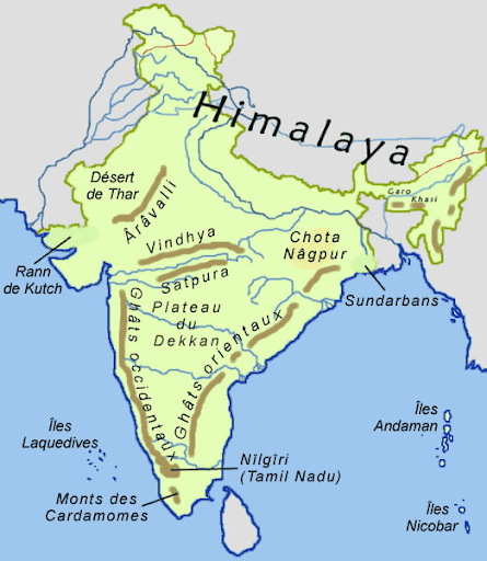
Image Credit:maps-of-india.com
Q2 On the map of India, mark the Himalayas.
Ans
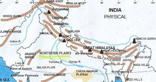
Image Credit:Pinterest
Also See :
Geography Important Questions
- India Size and Location Class 9 Geography Chapter 1 MCQs, Question Answers
- Drainage Class 9 Geography Chapter 3 MCQs, Question Answers
- Climate Class 9 Geography Chapter 4 MCQs, Question Answers
- Natural Vegetation and Wildlife Class 9 Geography Chapter 5 MCQs, Question Answers
History Important Questions
- The French Revolution Class 9 Chapter 1 Notes, MCQs, Question Answers
- Socialism in Europe and The Russian Revolution Class 9 Chapter 2 Notes, MCQs, Question Answers
- Nazism and The Rise of Hitler Class 9 Chapter 3 Notes, MCQs, Question Answers
- Forest Society and Colonialism Class 9 Chapter 4 Notes, MCQs, Question Answers/a>
- Pastoralists in The Modern World Class 9 Chapter 5 Notes, MCQs, Question Answers
Political Science Important Questions
- What is Democracy? Why Democracy Class 9 Chapter 1 Notes, MCQs, Question Answers
- Constitutional Design Class 9 Chapter 2 Notes, MCQs, Question Answers
- Electoral Politics Class 9 Chapter 3 Notes, MCQs, Question Answers
- Working of Institutions Class 9 Chapter 4 Notes, MCQs, Question Answers
- Democratic Rights Class 9 Chapter 5 Notes, MCQs, Question Answers