NCERT Solutions for Class 9 Geography Chapter 4 Climate
Climate Class 9 – Given in this post is NCERT Solutions Class 9 Geography Chapter 4 Climate Important Question Answers. The important questions we have compiled will help the students to brush up on their knowledge about the subject. Students can practice Class 9 Geography important questions to understand the subject better and improve their performance in the board exam. The NCERT Solutions Class 9 Social Science (Geography) provided here will also give students an idea about how to write the answers.
Chapter 4 Climate MCQ Based Questions
Q1 Which one of the following causes rainfall during winters in the northwestern part of India? (NCERT QUESTION)
A Cyclonic depression
B Retreating monsoon
C Western disturbances
D Southwest monsoon
Ans C Western disturbances
Q2 The word ‘monsoon’ is derived from the Arabic word
A Mausam
B Mausim
C Monsoon
D Mausin
Ans B Mausim
Q3 The ‘coriolis force’ is caused by
A the earth’s rotation
B wind movements
C jet streams
D cyclonic disturbances
Ans A the earth’s rotation
Q4 The full form of ITCZ is
A Inter Tropical Continental Zone
B Inter Typical Coriolis Zone
C Inter Tropical Convergence Zone
D Inter Tropical Cyclonic Zone
Ans C Inter Tropical Convergence Zone
Q5 The term ENSO is referred to
A El Nino Southern Onset
B El Nino Southern Oscillations
C En Nino Southern Oscillation
D None of these
Ans B El Nino Southern Oscillations
Q6 Around the time of arrival, normal rainfall increases suddenly and continues for several days. This is called
A Burst of monsoon
B onset of monsoon
C breaking of monsoon
D end of monsoon
Ans A Burst of monsoon
Q7 Strong, gusty, hot dry winds blowing during the day, over the north and north-west India are called: (NCERT QUESTION)
A dust storms
B loo
C Kaal Baisakhi
D none of these
Ans B loo
Q8 Monsoons retreat during the months of
A July and August
B August and September
C November and December
D October and November
Ans D October and November
Q9 Tropical cyclones are often very destructive and arrive on the coasts of
A Karnataka and Goa
B Odisha and West Bengal
C Maharashtra and Gujarat
D Kerala and Maharashtra
Ans B Odisha and West Bengal
Q10 Which one of the following places receives the highest rainfall in the world? (NCERT QUESTION)
A Cherrapunji
B Mawsynram
C Guwahati
D Shillong
Ans B Mawsynram
Related – Climate MCQs Question Answers
Q16 Which of the following winds bring widespread rainfall over the mainland of India?
A North-easterlies
B North-westerlies
C Sea breeze
D South-westerlies
Ans D South-westerlies
Q17 Which of the following causes destruction in West Bengal?
A Baisakhi
B Mango showers
C Jet streams
D Tropical cyclones
Ans A Baisakhi
Q18 Which one of the following are called pre-monsoon showers in Kerala?
A Kaal Baisakhi
B South-west monsoons
C Mango showers
D None of these
Ans C Mango showers
Q19 Which of these winds does the Coromandel Coast receive rainfall?
A South-west monsoon winds
B North-east monsoon winds
C Westerly jet streams
D South-easterly winds
Ans B North-east monsoon winds
Q20 Which of the following prevents the south-west monsoon winds from escaping India?
A The Malwa plateau
B The Deccan plateau
C The Chotanagpur plateau
D The Himalayas
Ans D The Himalayas
Q21 Monsoon arrives in India approximately in: (NCERT QUESTION)
A Early May
B Early July
C Early June
D Early August
Ans C Early June
Q22 Which one of the following characteristics is the cold weather season in India? (NCERT QUESTION)
A Warm days and warm nights
B Warm days and cold nights
C Cool days and cold nights
D Cold days and warm nights.
Ans B Warm days and cold nights
Q23 In which place in India are houses built on stilts?
A Bihar
B Assam
C Goa
D None of these
Ans B Assam
Q24 In which places of India there is very little difference between day and night temperatures?
A Bihar
B Bangalore
C Thiruvananthapuram
D All of these
Ans C Thiruvananthapuram
Q25 Most parts of India receive rainfall during which of the following months?
A June to September
B May to July
C September to March
D None of these
Ans A June to September
Q26 What do you mean by weather?
A State of the atmosphere over an area at any point of time
B Envelope of air surrounding earth
C Generalised monthly atmospheric conditions
D None of these
Ans A State of the atmosphere over an area at any point of time
Q27 Which one of the following is an element of weather and climate?
A Atmospheric pressure
B Temperature
C Humidity
D All of these
Ans D All of these
Q28 Which one of the following places in India has a cooler climate even during summers?
A Jaisalmer
B Surat
C Mussoorie
D All of these
Ans C Mussoorie
Q29 What does the word monsoon literally mean?
A Wind pattern
B Change
C Seasons
D All of these
Ans C Seasons
Q30 Which area is not an area of low precipitation in India?
A Assam
B Deccan plateau
C Both A and B
D None of these
Ans A Assam
1 Mark Questions
Q1 Which winds account for rainfall along the Malabar Coast? (NCERT QUESTION)
Ans Southwest monsoon winds are responsible for rainfall along the Malabar Coast.
Q2 Why does the rainfall decrease from the east to the west in Northern India? (NCERT QUESTION)
Ans As they move in that direction, the winds lose the moisture content. Hence, the reason for the reduction in rainfall.
Q3 Why does the seasonal reversal of wind direction take place over the Indian subcontinent? (NCERT QUESTION)
Ans 1. Seasonal change in wind direction due to pressure difference.
- El Nino plays a major role.
Q4 The bulk of rainfall in India is concentrated over a few months. Give reason why? (NCERT QUESTION)
Ans Rainfall is dependent on the South West Monsoon winds; it rapidly progresses and covers large swathes of the country by July.
Q5 The Tamil Nadu coast receives winter rainfall. Give reason why? (NCERT QUESTION)
Ans It is because of North-East monsoon winds.
Q6 The delta region of the eastern coast is frequently struck by cyclones. Give reason why? (NCERT QUESTION)
Ans The Bay of Bengal faces frequent pressure changes.
Q7 Parts of Rajasthan, Gujarat and the leeward side of the Western Ghats are drought-prone. Give reason why? (NCERT QUESTION)
Ans Because they fall in the rain shadow region of the Aravali Mountains.
Q8 What is climate?
Ans Climate refers to the sum total of weather conditions over a large area for a long period of time (30 – 40 years).
Q9 Distinguish between climate and weather.
Ans Climate refers to the sum total of weather conditions and variations over a large area for a long period of time (thirty years). Weather refers to the state of the atmosphere over an area at any point of time.
Q10 Name the elements of climate and weather.
Ans Elements of weather and climate are temperature, atmospheric pressure, wind, humidity and precipitation.
Q11 What is the climate of India?
Ans India’s climate is described as “Tropical Monsoon Type of Climate”.
Q12 What does the word ‘Monsoon’ mean?
Ans The word Monsoon is derived from the Arabic word ‘mausim’ which literally means season. It refers to the seasonal reversal in the wind direction during a year.
Q13 What is the variation of temperature in summer in India?
Ans In summer, the mercury occasionally touches 50°C in some parts of Rajasthan desert, whereas it may be around 20°C in Pahalgam in Jammu and Kashmir.
Q14 What is the variation of temperature in winter in India?
Ans In winter, the temperature in Drass in Jammu and Kashmir is as low as – 45°C and Thiruvananthapuram may have 22°C.
Q15 What is the variation of annual precipitation in India?
Ans The annual precipitation is over 400 cms in Meghalaya and less than 10 cms in Ladakh and western Rajasthan.
Q16 In which months is the season of rainfall experienced in India?
Ans Most parts of India receive rainfall from June to September.
Q17 Why do the coastal areas of India experience less contrast in temperature?
Ans The coastal areas experience less contrast in temperature because of the influence of the sea, e.g. Mumbai experiences an equal climate.
Q18 Why is there a decrease in rainfall from east to west in the Northern Plains?
Ans There is a general decrease in the amount of rainfall from east to west in the Northern Plains as the winds have less moisture in them when they reach the western side.
Q19 What does the term continentality mean?
Ans As the distance from the sea increases the moderating influence of the sea decreases and the people experience extreme weather conditions. This is called continentality i.e. very hot in summers and cold in winters, e.g. in Delhi.
Q20 Why does the amount of solar radiation vary with latitude?
Ans The amount of solar radiation varies with latitude because of the curvature of the earth. The temperature decreases from the equator to the poles.
Q21 How does the temperature decrease with altitude?
Ans The temperature of air decreases at the rate of 1°C for every 165 m of ascent. This is because the air density decreases with height. That is why hills are cooler in summers.
Q22 Which two factors affect the wind and pressure system of an area and how?
Ans The latitude and the altitude of the place affect the temperature and rainfall of the area.
Q23 What are ocean currents? Name the two types.
Ans Ocean currents are streams of water that move in the same direction throughout the year. The two types of ocean currents are warm currents and cold currents.
Q24 Which parallel of latitude passes through the centre of India?
Ans The parallel of latitude is the Tropic of Cancer, 23½°N.
Q25 What is the influence of the division of India by the Tropic of Cancer?
Ans The Tropic of Cancer divides India into the Tropical zone which lies to the south and the sub-tropical area which lies to the north. It gives India’s climate a tropical and a sub-tropical character.
Q26 What is Coriolis force?
Ans It is an apparent force caused by the earth’s rotation. The Coriolis force is responsible for deflecting the winds to the right in the northern hemisphere and towards the left in the southern hemisphere, due to the rotation of the earth.
Q27 What do you know about South-Western Monsoon Winds?
Ans Air moves from the high pressure area over the southern Indian Ocean in a south easterly direction, crosses the equator and gets deflected towards the right towards the low pressure area over the Indian subcontinent. This is known as the south western monsoon.
Q28 What are jet streams?
Ans Jet streams are fast flowing winds at high altitudes above 12,000 metres in the troposphere.
Q29 What are sub-topical westerly jet streams?
Ans The sub-tropical westerly jet streams are located approximately over 27° – 30° north latitude.
Q30 In which parts of India the sub-tropical westerly jet streams blow?
Ans The sub-tropical westerly jet streams flow south of the Himalayas all through the year except in summers. They are responsible for the western cyclonic disturbances in north and north western parts.
Q31 What are tropical easterly jet streams?
Ans An easterly jet stream known as the tropical easterly jet stream blows over peninsular India approximately at 14°N during the summer months.
Q32 What are western cyclonic disturbances?
Ans These are shallow cyclonic depressions which originate over the east Mediterranean sea, travel eastwards and influence the weather conditions of north western parts of India during winters.
Q33 Which warm ocean current replaces the Peruvian cold current?
Ans El Nino.
Q34 On what basis is the year divided into seasons?
Ans On the basis of the generalised monthly atmospheric conditions.
Q35 What does the word ‘Monsoon’ refer to?
Ans The word ‘Monsoon’ refers to the seasonal reversal in the wind direction during a yean
Q36 Where is the monsoonal type of climate found in Asia?
Ans In south and southeast Asia.
Q37 Name the two elements which are responsible for the regional variations within the country.
Ans The two important elements are temperature and precipitation.
Q38 What is the temperature in Rajasthan in summer?
Ans 50°C
Q39 Where is Drass located? What are the winter temperatures?
Ans Drass is located in Jammu and Kashmir. The winter temperatures are as low as minus 45°C.
Q40 Why do the houses in Rajasthan have thick walls and flat roofs?
Ans The houses in Rajasthan have thick walls to prevent them from becoming hot. The thick walls keep the interior cool. The flat roofs are used to collect water when it rains and in summer they are used for drying dates and storage purposes.
Q41 Why are houses in Assam built on stilts?
Ans Assam receives very heavy rain and often water accumulates on the ground. There is a thick undergrowth which makes it difficult for the people to live. So houses are built above the ground level on stilts.
Q42 Why do houses in the Terai region, Goa and Mangalore have sloping roofs?
Ans All the three regions, the Terai, Goa and Mangalore have very heavy rainfall. The sloping roofs of the houses enable the rainwater to flow off easily.
Q43 Why is the climate of India known as having a tropical monsoon character?
Ans Because the climate of India is strongly influenced by the monsoon winds.
Q44 How did the sailors who came to India in historic times benefit from the monsoon winds?
Ans In the olden times the movement of ships depended on the mercy of winds. The sailors and the Arab traders found the monsoon winds helpful, due to the reversal of the wind system.
Q45 What is the duration of the monsoon?
Ans 100-120 days from June to mid-September.
Q46 Explain the term ‘burst’ of the monsoon.
Ans Around the time of its arrival, the normal rainfall suddenly increases and it continues to rain for several days. This is known as the ‘burst’ of the monsoon.
Q47 Name the two branches of the South West Summer Monsoon.
Ans Bay of Bengal Branch Arabian sea Branch.
Q48 What causes the Bay of Bengal branch of the S.W. Summer Monsoons to be deflected towards the west over the Ganga plains?
Ans The lofty Himalayas and the low pressure in N.W. India attracts the Monsoons.
Q49 Why does the global heat belt shift northwards in the summer season?
Ans It shifts northwards due to the apparent northward movement of the sun.
Q50 Name any two states which are affected by the Tropical cyclones.
Ans Tamil Nadu, Odisha.
Q51 Why do the Monsoon winds change their direction? Give any one reason.
Ans Monsoon winds change their direction when the lofty Himalayas obstruct their passage. For example, the Himalayas cause the monsoon winds to deflect towards the west over the Ganga Plains.
Q52 Give two examples of pre-monsoon showers.
Ans The two examples of pre-monsoon showers are the ‘mango showers’ in Kerala and Karnataka and the ‘Kaal Baisakhi’ which causes rainfall in West Bengal.
Q53 Name the major seasons of India.
Ans (a) The cold weather season (winter)
(b) The hot weather season (summer)
(c) Rainy season
(d) Retreating season
Q54 Name the three basic elements that one learns about while studying the natural environment of any area.
Ans The three basic elements are.
(a) Landforms
(b) Drainage
(c) Atmospheric Conditions
Q55 What is the form of precipitation in the upper parts of the Himalayas, Meghalaya and western Rajasthan?
Ans (a) Upper parts of the Himalayas – snow.
(b) Meghalaya – Rainfall of over 400 cm.
(c) Western Rajasthan – Rainfall of about 10 cm.
Q56 What is the duration of the Summer season?
Ans March to May.
Q57 State the temperature and pressure conditions in the Hot Weather season.
Ans The summer months experience rising temperature and falling air pressure. Deccan: 38°C Gujarat and M.P: 42°C N.W. India: 45°C
Q58 Name the local winds blowing in summer.
Ans The Loo, Kaal Baisakhi and Mango showers.
Assertion-reason based questions:
Q1 Assertion (A): Even though only the southern part of India lies in the tropical region, almost the whole of India experiences a tropical climate.
Reason (R): The Himalayan mountains act as a barrier and prevent the northerly cold winds from entering India.
Options:
- Both A and R are true and R is the correct explanation of A.
- Both A and R are true but R is not the correct explanation of A.
- A is true but R is false.
- A is false but R is true.
Ans A. Both A and R are true and R is the correct explanation of A.
Though only the southern part of India is located in the tropical belt, the entire country is dominated by tropical climate. This is because of the presence of Himalayas in north India. Himalayas due to its humongous size work as barriers in the north. They block cold winds coming from the north, thus protecting the country from having extreme and harsh winters. This enforces the whole India to experience tropical climates.
Q2 Assertion (A): India has a tropical monsoon type climate.
Reason (R): India is located exactly between the tropical latitudes.
Options:
- Both A and R are true and R is the correct explanation of A.
- Both A and R are true but R is not the correct explanation of A.
- A is true but R is false.
- A is false but R is true.
Ans C. A is true but R is false.
Yes, India has a tropical monsoon type climate, but it is not true that India is located exactly between the tropical latitudes.
Q3 Assertion (A): Although only the southern part of India lies in the tropical region, the whole of India has a tropical climate.
Reason (R): Himalaya mountain ranges protect it from the northerly cold winds.
Options:
- Both A and R are true and R is the correct explanation of A.
- Both A and R are true but R is not the correct explanation of A.
- A is true but R is false.
- A is false but R is true.
Ans A. Both A and R are true and R is the correct explanation of A.
The assertion is true and the reason is the correct explanation of the assertion. The Himalayas are the main mountain range of our country and they are situated in the northern part of our country. This mountain range manipulates our country’s climate in various ways. Due to its humongous size, it blocks the cold winds coming from the north and thus protects our country from having harsh winters.
Q4 Assertion (A): The monsoon type of climate is characterized by a distinct seasonal pattern.
Reason (R): The weather conditions greatly change from one season to the other.
Options:
- Both A and R are true and R is the correct explanation of A.
- Both A and R are true but R is not the correct explanation of A.
- A is true but R is false.
- A is false but R is true.
Ans A. Both A and R are true and R is the correct explanation of A.
Q5 Assertion (A): The world is divided into a number of climatic regions.
Reason (R): The climate of India is described as the ‘monsoon’ type.
Options:
- Both A and R are true and R is the correct explanation of A.
- Both A and R are true but R is not the correct explanation of A.
- A is true but R is false.
- A is false but R is true.
Ans B. Both A and R are true but R is not the correct explanation of A.
Climate reflects the cumulative amount of conditions (including variations) for a long period over wide areas (more than thirty years)
Q6 Assertion (A): The climate of India is strongly influenced by monsoon winds.
Reason (R): The pressure and winds over India are unique.
Options:
- Both A and R are true and R is the correct explanation of A.
- Both A and R are true but R is not the correct explanation of A.
- A is true but R is false.
- A is false but R is true.
Ans B. Both A and R are true but R is not the correct explanation of A.
Monsoon winds over the warm Tropical Seas are influenced by various atmospheric conditions. The monsoon continues from the beginning of June to mid-September for 100-120 days. The rainfall unexpectedly rises as the monsoon arrives. It lasts many days endlessly. This is considered the monsoon burst. It’s different from the rain before the monsoon.
Q7 Assertion (A): Indian sub-continent experiences comparatively milder winters as compared to central Asia.
Reason (R): The Himalayas prevent the cold winds from Central Asia from entering the subcontinent.
Options:
- Both A and R are true and R is the correct explanation of A.
- Both A and R are true but R is not the correct explanation of A.
- A is true but R is false.
- A is false but R is true.
Ans A. Both A and R are true and R is the correct explanation of A.
The Northern Indian mountains average about 6000 meters in height. In comparison, India’s huge coastal region is just about 30 meters high. The Himalayas block the cold winds from penetrating the subcontinent in Indian soils, in contrast with Central Asia.
Q8 Assertion (A): The Peninsular region does not have a well defined cold season.
Reason (R): Temperature pattern of the region remains more or less the same due to moderating influence of the sea.
Options:
- Both A and R are true and R is the correct explanation of A.
- Both A and R are true but R is not the correct explanation of A.
- A is true but R is false.
- A is false but R is true.
Ans A. Both A and R are true and R is the correct explanation of A.
There is water on three sides of the peninsula. During day and night, the temperature is moderate, and the atmosphere is not severe. There is an exchange between sea breezes and ground brises. Hope the reaction was helpful.
Fill in the blanks in the following:
Q1 In the olden times the movement of ships depended on the __________.
Ans mercy of winds
Q2 ______________ are shallow cyclonic depressions which originate over the east Mediterranean sea, travel eastwards and influence the weather conditions of north western parts of India during winters.
Ans Western cyclonic disturbances
Q3 The full form of ENSO is _____________.
Ans El Nino Southern Oscillations
Q4 Monsoons retreat during the months of _____________.
Ans October and November
Q5 Tropical cyclones are often very destructive and arrive on the coasts of __________.
Ans Odisha and West Bengal
Q6 Monsoon arrives in India approximately in __________.
Ans Early June
Q7 In ________ are houses built on stilts in India.
Ans Assam
Q8 The Bay of Bengal faces frequent ____________.
Ans pressure changes
Q9 Air moves from the high pressure area over the southern Indian Ocean in a south easterly direction, crosses the equator and gets deflected towards the right towards the low pressure area over the Indian subcontinent. This is known as the ________________.
Ans south western monsoon
Q10 ___________ are fast flowing winds at high altitudes above 12,000 metres in the troposphere.
Ans Jet streams
2 Mark Questions
Q1 What are the factors affecting the climate of India? (NCERT QUESTION)
Ans The factors affecting the climate of India are
- Latitude
- Altitude
- Pressure and Winds
Q2 Which part of India does experience the highest diurnal range of temperature and why? (NCERT QUESTION)
Ans The regions experiencing this phenomenon are in the northwestern part of India. The reason behind this effect is the Thar desert. Moreover, this region does not have an ocean to moderate the temperature.
Q3 What are Jet streams, and how do they affect the climate of India? (NCERT QUESTION)
Ans Jet Streams are a narrow belt of high altitude (above 12,000 m) westerly winds in the troposphere. Their speed varies from about 110 km/h in summer to about 184 km/h in winter. A number of separate jet streams have been identified. The most constant is the mid-latitude and subtropical jet stream. They cause depression during the monsoon season.
Q4 How does the relief of an area affect the climate of a place?
Ans The relief of a place affects the climate of a place when the high mountains act as barriers for cold and hot winds, e.g. the Himalayas. They also affect the amount of rainfall if they are very high. They force the wind to give heavy rain on the windward side and less rain on the leeward side.
Q5 When and how do the following parts of the country get their rainfall:
Tamil Nadu, Northern Plains.
Ans (a) Tamil Nadu receives its rainfall in winter from the N E Winter Monsoons and tropical cyclones.
(b) The Northern plains receive rainfall between June and September from the South West Monsoons.
Q6 Study the table given below and answer the following questions:
| Station A | Latitude | Altitude |
| A | 12 degree N | 909 m |
| B | 26 degree N | 160 m |
- What type of climate does station A have and why?
- What type of climate does station B have and why?
Ans 1. Since station A is located closer to the equator and at a height of 909 meters it has a moderate climate.
- Station B is located at 26°N in the interior of the country, north of the Tropic of Cancer.
3 Mark Questions
Q1 Define monsoons. What do you understand by “break” in monsoon? (NCERT QUESTION)
Ans 1. Breaks in monsoon are related to the movement of the monsoon trough. For various reasons, the trough and its axis keep on moving northward or southward, which determines the spatial distribution of rainfall.
- When the axis of the monsoon trough lies over the plains, rainfall is good in these parts.
- On the other hand, whenever the axis shifts closer to the Himalayas, there are longer dry spells in the plains, and widespread rain occurs in the mountainous catchment areas of the Himalayan rivers.
Q2 Describe the regional variations in the climatic conditions of India with the help of suitable examples. (NCERT QUESTION)
Ans 1. The cold weather season begins in mid-November in northern India and stays till February. December and January are the coldest months in the northern part of India. The temperature decreases from south to north.
- The average temperature of Chennai, on the eastern coast, is between 24°-25° Celsius, while in the northern plains, it ranges between 10°C and 15° Celsius. Days are warm, and nights are cold. Frost is common in the north, and the higher slopes of the Himalayas experience snowfall
- In March, the highest temperature is about 38° Celsius, recorded on the Deccan plateau. In April, temperatures in Gujarat and Madhya Pradesh are around 42° Celsius. In May, the temperature of 45° Celsius is common in the northwestern parts of the country. In peninsular India, temperatures remain lower due to the moderating influence of the oceans.
Q3 How do the variations in temperature affect the lives of the people in India?
Ans 1. They affect the food the people eat.
- The clothes the people wear
- The kind of houses they live in.
Q4 What is the jet stream?
Ans 1. These are a narrow belt of high altitude westerly winds in the troposphere.
- Their speed varies from about 110 km/h in summer to about 184 km/h in winter.
- Of the jet streams that have been identified, the most constant are the mid-latitude and the subtropical jet stream.
Q5 What is the ITCZ?
Ans 1. The Inter Tropical Convergence Zone is a low pressure trough lying 5° North and South of the Equator.
- The North East and the South East Trade winds meet here.
- The ITCZ moves north or south of the Equator with the apparent movement of the sun.
Q6 Explain the Southern Oscillation.
Ans 1. Normally when the tropical eastern South Pacific Ocean experiences high pressure, the tropical eastern Indian Ocean experiences low pressure.
- Sometimes there is a reversal in the pressure conditions.
- This periodic change in pressure conditions is known as the Southern Oscillation or S.O. If the pressure differences are negative it would mean late monsoons.
Q7 How is the El Nino phenomenon connected with the Southern Oscillation?
Ans 1. Normally a cold current flows along the Peruvian Coast.
- Every two to five years a warm ocean current takes the place of the cold Peruvian current.
- The changes in the pressure conditions are connected to the El Nino, so this phenomenon is referred to as ENSO (El Nino Southern Oscillations).
Q8 What do you understand by the ‘Retreating of the Monsoon’? When does it occur?
Ans 1. Withdrawal of the monsoon from the country is known as the retreating of the monsoon.
- The withdrawal is a gradual process. In September the monsoon withdraws from the north western states and by October from the northern half of the peninsula.
- The monsoon finally withdraws from the country by early December.
Q9 Describe the main features of the Retreating Monsoon season in India.
Ans The main features of the Retreating Monsoon season in India are:
- During October-November the monsoon trough becomes weaker. It is gradually replaced by a high pressure system. The south-west monsoon winds start withdrawing gradually. By the beginning of October the monsoon withdraws completely from the northern plains.
- The months of October and November are a period of change from hot rainy season to dry winter conditions. The land is moist, the sky is clear and the temperature rises. Nights are cool and pleasant. Owing to high temperature and humidity, the heat becomes oppressive during daytime and it is called ‘October heat’.
- The low pressure conditions get transferred over the Bay of Bengal by the beginning of November. This shift is associated with the occurrence of cyclonic depression, which develops over the Andaman Sea. These cyclones cross the eastern coast and cause heavy rainfall. They are destructive and the deltas of the Godavari, Krishna and Kaveri are often struck by them.
Q10 What are the temperate cyclones? How do they influence the climate of India?
Ans 1. Temperate cyclone, also known as depression, enters India from the Mediterranean Sea in the cold season.
- These cause winter rains over the Northern plains and snowfall in the mountains.
- The winter rainfall locally known as ‘mahawat’ is small, but is very important for the cultivation 0of rabi crops.
Q11 Write short notes on the local winds of the Hot/Summer season.
Ans 1. Loo: These are strong, gusty, hot dry winds blowing during the day over north and north west India. Dust storms are common.
- Kaal Baisakhi: These are the localised thunderstorms, accompanied by violent winds, torrential rain, sometimes accompanied by hail. These occur in West Bengal.
- Mango showers: These are the pre-monsoon showers, which occur in Kerala and Karnataka at the end of the summer season. These help in the ripening of mangoes.
Q12 How are the Trade Winds related to the Monsoon Winds?
Ans 1. The South East Trade winds originate over the warm subtropical areas of the southern oceans.
- Due to the intense low pressure over the northwest of India, the Trade Winds cross the equator and blow in a south westerly direction towards the Indian peninsula.
- These blow over the warm ocean, pick up moisture and then blow into the Indian peninsula causing heavy rain there. These winds enter India as the South West Monsoon winds.
Q13 What is the pattern of annual rainfall distribution in India? Name any two states having heavy rainfall, two states having moderate rainfall and two having low rainfall.
Ans 1. The annual rainfall is highly variable from year to year. Parts of western coast and north eastern India receive heavy rainfall.
- Rainfall is low in Deccan plateau, east Sahyadris, Leh, Rajasthan, Gujarat. The rest of the country receives moderate rainfall.
- Thus the pattern of annual rainfall distribution is uneven in India. Heavy rainfall – Meghalaya, Arunachal Pradesh Moderate rainfall – Uttar Pradesh, Tamil Nadu Low rainfall – Rajasthan, Gujarat
Q14 Explain any three factors which affect the mechanism of monsoons.
Ans The three factors are:
- The presence of land and water causes the differences in temperature. This results in differences in pressure which gives rise to the monsoons. The monsoon winds blow from high pressure to low pressure. This determines the direction of winds.
- The movement of the westerly jet stream to the north of the Himalayas and the presence of the easterly jet stream over the peninsula during summer.
- The shift of the position of the Inter Tropical Convergence zone in summer over the Ganga plain (normal position is about 5°N of the equator).
Q15 Development of tropical cyclones is a distinguishing feature of the monsoon. How do tropical cyclones influence distribution of rainfall in India?
Ans 1. The low pressure conditions over north western India slowly get transferred to the Bay of Bengal by early November. The occurrence of cyclonic depression is a result of this shift.
- The tropical cyclones move westwards towards the east coast of India and cause heavy rainfall there.
- These cyclones are very destructive and cause great damage to life and property. Most of the winter rain along the east coast is caused by these depressions.
4 Mark Questions
Q1 Read the extract given below and answer the questions that follow:
The cold weather season begins in mid-November in northern India and stays till February. December and January are the coldest months in the northern part of India. The temperature decreases as we go from the south to the north. The average temperature in Chennai, on the eastern coast, is between 24°-25° Celsius. At the same time, in the northern plains, it ranges between 10°C and 15° Celsius. Here, the days are warm, and the nights are cold. Frost is common in the north, and the higher slopes of the Himalayas experience snowfall. During this season, the northeast trade winds prevail over the country. They blow from land to sea, and hence, for the most part of the country, it is a dry season. Some amount of rainfall occurs on the Tamil Nadu coast from these winds as here they blow from sea to land. In the northern part of the country, a feeble high-pressure region develops, with light winds moving outwards from this area. Influenced by the relief, these winds blow through the Ganga Valley from the west and the northwest. The weather is normally marked by clear sky, low temperatures and low humidity and feeble, variable winds. A characteristic feature of the cold weather season over the northern plains is the inflow of cyclonic disturbances from the west and the northwest. These low-pressure systems originate over the Mediterranean Sea and western Asia and move into India along with the westerly flow. They cause much-needed winter rains over the plains and snowfall in the mountains. Although the total amount of winter rainfall (locally known as ‘Mahawat’) is small, they are of immense importance for the cultivation of ‘rabi’ crops. The peninsular region does not have a well-defined cold season. There is hardly any noticeable seasonal change in temperature patterns during winters due to the moderating influence of the sea.
- When does the cold weather season begin in India?
Ans The cold weather season begins in mid-November in northern India and stays till February.
- Which winds prevail over the country?
Ans During this season, the northeast trade winds prevail over the country. They blow from land to sea, and hence, for the most part of the country, it is a dry season.
- State a characteristic feature of the cold weather season.
Ans A characteristic feature of the cold weather season over the northern plains is the inflow of cyclonic disturbances from the west and the northwest.
- State the local name of winter rainfall.
Ans ‘Mahawat’
Q2 Read the extract given below and answer the questions that follow:
The Monsoon, unlike the trades, is not a steady wind but is pulsating in nature, affected by different atmospheric conditions encountered by it on its way over the warm tropical seas. The duration of the monsoon is between 100-120 days from early June to mid-September. Around the time of its arrival, the normal rainfall increases suddenly and constantly continues for several days. This is known as the ‘burst’ of the monsoon and can be distinguished from the pre-monsoon showers. The monsoon arrives at the southern tip of the Indian peninsula, generally by the first week of June. Subsequently, it proceeds into two: the Arabian Sea branch and the Bay of Bengal branch. The Arabian Sea branch reaches Mumbai about ten days later on approximately the 10th of June. This is a fairly rapid advance. The Bay of Bengal branch also advances rapidly and arrives in Assam in the first week of June. The lofty mountains cause the monsoon winds to deflect towards the west over the Ganga Plains. By mid-June, the Arabian Sea branch of the monsoon arrives over Saurashtra-Kachchh and the central part of the country. The Arabian Sea and the Bay of Bengal branches of the monsoon merge over the northwestern part of the Ganga Plains. Delhi generally receives the monsoon showers from the Bay of Bengal branch by the end of June (tentative date is 29th of June). By the first week of July, western Uttar Pradesh, Punjab, Haryana and eastern Rajasthan experience the monsoon. By mid-July, the monsoon reaches Himachal Pradesh and the rest of the country.
- State the duration of the monsoon.
Ans The duration of the monsoon is between 100-120 days from early June to mid-September.
- What do you mean by the ‘burst’ of the monsoon?
Ans Around the time of the arrival of the monsoon, the normal rainfall increases suddenly and constantly continues for several days. This is known as the ‘burst’ of the monsoon and can be distinguished from the pre-monsoon showers.
- Name the two branches of the South West Summer Monsoon.
Ans Bay of Bengal Branch Arabian sea Branch.
- What causes the Bay of Bengal branch of the S.W. Summer Monsoons to be deflected towards the west over the Ganga plains?
Ans The lofty Himalayas and the low pressure in N.W. India attracts the Monsoons.
5 Mark Questions
Q1 Why does India have a monsoon type of climate? (NCERT QUESTION)
Ans 1. The climate of India is described as the ‘monsoon’ type. Monsoon refers to the seasonal reversal in the wind direction during a year.
- The monsoon type of climate is characterized by a distinct seasonal pattern. The weather conditions greatly change from one season to the other.
- These changes are particularly noticeable in the interior parts of the country. The coastal areas do not experience much variation in temperature, though there is variation in the rainfall pattern.
- Four main seasons can be identified in India – the cold weather season, the hot weather season, the advancing monsoon and the retreating monsoon with some regional variations.
- The climate of India is strongly influenced by monsoon winds. The duration of the monsoon is between 100-120 days from early June to mid-September.
Q2 Why is the monsoon considered a unifying bond? (NCERT QUESTION)
Ans 1. The unifying influence of the monsoon on the Indian subcontinent is quite perceptible.
- The seasonal alteration of the wind systems and the associated weather conditions provide a rhythmic cycle of seasons.
- Even the uncertainties of rain and uneven distribution are very much typical of the monsoons. The Indian landscape, its animal and plant life, its entire agricultural calendar and the life of the people (including their festivities) revolve around this phenomenon.
- Year after year, the people of India, from north to south and from east to west, eagerly await the arrival of the monsoon.
- These monsoon winds bind the whole country by providing water to set agricultural activities in motion. The river valleys which carry this water also unite as a single river valley unit.
Q3 Discuss the mechanisms of the monsoon. (NCERT QUESTION)
Ans 1. The differential heating and cooling of land and water create a low pressure on the landmass of India while the seas around experience comparatively high pressure.
- The shift of the position of Inter Tropical Convergence Zone (ITCZ) in summer over the Ganga Plain. (This is the equatorial trough, normally positioned about 5°N of the equator. It is also known as the monsoon trough during the monsoon season.)
- The presence of the high-pressure area, east of Madagascar, approximately at 20°S over the Indian Ocean. The intensity and position of this high-pressure area affect the Indian Monsoon.
- The Tibetan Plateau gets intensely heated during summer, which results in strong vertical air currents and the formation of low pressure over the plateau at about 9 km above sea level.
- The movement of the westerly jet stream to the north of the Himalayas and the presence of the tropical easterly jet stream over the Indian peninsula during summer.
Q4 Give an account of weather conditions and characteristics of the cold season.
Ans 1. The cold weather season begins in mid-November in northern India and stays till February. December and January are the coldest months in the northern part of India. The temperature decreases as we go from the south to the north.
- The average temperature in Chennai, on the eastern coast, is between 24°-25° Celsius. At the same time, in the northern plains, it ranges between 10°C and 15° Celsius. Here, the days are warm, and the nights are cold.
- Frost is common in the north, and the higher slopes of the Himalayas experience snowfall. During this season, the northeast trade winds prevail over the country. They blow from land to sea, and hence, for the most part of the country, it is a dry season.
- Some amount of rainfall occurs on the Tamil Nadu coast from these winds as here they blow from sea to land. In the northern part of the country, a feeble high-pressure region develops, with light winds moving outwards from this area.
- Influenced by the relief, these winds blow through the Ganga Valley from the west and the northwest. The weather is normally marked by clear sky, low temperatures and low humidity and feeble, variable winds.
- A characteristic feature of the cold weather season over the northern plains is the inflow of cyclonic disturbances from the west and the northwest.
- These low-pressure systems originate over the Mediterranean Sea and western Asia and move into India along with the westerly flow. They cause much-needed winter rains over the plains and snowfall in the mountains.
- Although the total amount of winter rainfall (locally known as ‘Mahawat’) is small, they are of immense importance for the cultivation of ‘rabi’ crops. The peninsular region does not have a well-defined cold season. There is hardly any noticeable seasonal change in temperature patterns during winters due to the moderating influence of the sea.
Q5 Give the characteristics and effects of the monsoon rainfall in India. (NCERT QUESTION)
Ans 1. The Monsoon, unlike the trades, is not a steady wind but is pulsating in nature, affected by different atmospheric conditions encountered by it on its way over the warm tropical seas.
- The duration of the monsoon is between 100-120 days from early June to mid-September. Around the time of its arrival, the normal rainfall increases suddenly and constantly continues for several days. This is known as the ‘burst’ of the monsoon and can be distinguished from the pre-monsoon showers.
- The monsoon arrives at the southern tip of the Indian peninsula, generally by the first week of June. Subsequently, it proceeds into two: the Arabian Sea branch and the Bay of Bengal branch. The Arabian Sea branch reaches Mumbai about ten days later on approximately the 10th of June. This is a fairly rapid advance.
- The Bay of Bengal branch also advances rapidly and arrives in Assam in the first week of June. The lofty mountains cause the monsoon winds to deflect towards the west over the Ganga Plains. By mid-June, the Arabian Sea branch of the monsoon arrives over Saurashtra-Kachchh and the central part of the country. The Arabian Sea and the Bay of Bengal branches of the monsoon merge over the northwestern part of the Ganga Plains.
- Delhi generally receives the monsoon showers from the Bay of Bengal branch by the end of June (tentative date is 29th of June). By the first week of July, western Uttar Pradesh, Punjab, Haryana and eastern Rajasthan experience the monsoon. By mid-July, the monsoon reaches Himachal Pradesh and the rest of the country.
Q6 Study the table given below and answer the following questions:
| Station A | Jan | Feb | March | April | May | June | July | Aug | Sep | Oct | Nov | Dec |
| Temp in Celcius | 24.5 | 25.7 | 27.7 | 30.4 | 33.0 | 32.5 | 31.0 | 30.2 | 29.8 | 28.0 | 25.9 | 24.7 |
| R.F. in cm | 4.6 | 1.3 | 1.3 | 1.8 | 3.8 | 4.5 | 8.7 | 11.3 | 11.9 | 30.6 | 35.0 | 13.9 |
- Calculate the average temperature of this place.
- Which is the rainiest month and the driest month of this station?
- What is the range of temperature of this station?
- What type of climate does the place have and why?
Ans 1. 28.6° C
- November is the rainiest month. February and March are the driest months.
- Range of Temperature is (33.0 – 24.5) = 8.5°C.
- The respective station has a maritime climate because there is not much difference between the highest and lowest temperature of the year. In other words it has an equable climate.
Q7 Explain any five factors that affect the climate of India.
Ans 1. Pressure: In winter the pressure is high over the land and low over the sea. Therefore cold winds blow from land to the sea. In summer the winds blow from sea to land where the pressure is low.
- Distance from the Sea: Places near the sea have a moderate climate due to the influence of land and sea breezes. Places far away in the interior have a continental or extreme climate.
- Ocean Currents: Ocean currents affect the coastal regions. Cold currents reduce the temperature of the regions they blow along. Warm currents increase the temperature of coastal regions.
- Relief: Mountains lying at right angles to the winds cause heavy rainfall whereas mountains lying parallel to the winds do not cause rain. Windward slopes of mountains cause heavier rain than the leeward slope or the rain shadow area.
- Latitude: Due to the spherical shape of the earth the amount of solar energy received by the earth varies according to the latitude. Temperature decreases from the Equator to the poles.
Q8 Describe the path of the monsoon winds, after it strikes the West Bengal coast.
Ans 1. The Bay of Bengal Branch first strikes the coast of Bangladesh and then proceeds towards Assam in the first week of June.
- The high mountains cause the monsoon winds to deflect towards the west over the Ganga plains.
- The rainfall keeps on decreasing as the winds move up the Ganga Valley.
- By mid-June, the Arabian Sea Branch meets the Bay of Bengal Branch.
- The monsoon reaches Delhi by 29th June. Uttar Pradesh, Punjab, Haryana and eastern Rajasthan receive rain by the 1st week of July and Himachal Pradesh by mid-July.
Q9 Explain the distribution of rain caused by the Monsoons.
Ans 1. Heavy rainfall (over 250 cm) is caused on the windward slopes of the Western Ghats.
2.The Deccan plateau and parts of Madhya Pradesh lie in the rain shadow area of the Ghats and get less rain.
- The north eastern part of the country receives very heavy rain (Mawsynram receives the highest rainfall in the world).
- Rain in the Ganga plain decreases from the east to the west.
- Rajasthan and parts of Gujarat get scanty rainfall.
Q10 Explain the four features of the Monsoon rains.
Ans 1. The Monsoon is often irregular in its arrival and retreat.
- The rainfall is unevenly distributed. Certain regions lying on the windward slopes of the mountains receive heavy rain while those in the rain shadow area receive less.
- The amount of rain varies annually.
- The rainfall is concentrated within the three months of the year.
- The alternation of dry and wet spells vary in intensity. At one place the rainfall is very heavy causing floods while at another place it might have famines.
Q11 Describe the regional variations in the climatic conditions of India with the help of suitable examples.
Ans There are great variations in the climate of India.
- Certain regions receive very heavy rainfall like the North-east and the Western Coastal plains while others like the Thar Desert receive scanty rainfall.
- Places like Ladakh and Kashmir are very cold while others like Rajasthan are very hot.
- Coastal regions have an equable climate while places in the interior have an extreme climate.
- Areas on the windward slopes of the mountains receive heavy rainfall, while leeward and rain shadow areas receive less rain.
- Coastal areas with warm currents flowing past it, will be warmer than those areas which have the cold currents flowing close to it.
Q12 Describe the role of El Nino and Southern Oscillation to control the climate of India.
Ans 1. The periodic change in pressure conditions in eastern Pacific and eastern Indian Ocean is known as the Southern Oscillation.
- The difference in pressure in the Indian and Pacific Oceans is computed to predict the intensity of the monsoons.
- Negative pressure differences predict below average and late Monsoons.
- This affects the El Nino, a warm current which flows along the Peruvian current instead of the cold current.
5.The changes in pressure conditions are connected to the El Nino.
Q13 Why is the distribution of rainfall uneven in India? Mention any five factors.
Ans The distribution of rainfall is uneven in India because:
- Relief: The Western Ghats receives heavy rainfall. The Arabian sea branch of the South-West monsoon, which are moisture laden winds, causes very heavy rainfall when they strike the Western Ghats. Mawsynram gets more rain due to its relief. It gets rain from the Bay of Bengal branch of the South-West monsoon.
- Distance from the Sea: Places near the coastal region get more rainfall than the places situated far away from the sea.
- Direction of the Winds: Rajasthan gets scanty rainfall due to Arabian sea Branch blowing parallel to the Aravalli hills.
- Inter-Tropical Convergence Zone (ITCZ): It is also known as monsoon trough during the monsoon season. The trough and its axis keep on shifting, northward or southward, which determines the spatial distribution of rainfall. When the trough lies over the plains, rainfall is over this region. When the axis shifts closer to the Himalayas, there is a dry spell over the plains and widespread rainfall in mountainous catchment areas.
- Cyclonic disturbances: The occurrence of cyclonic depressions, which originate over Andaman Sea, generally cross the eastern coasts of India cause heavy and widespread rain in deltas of the Godavari, the Krishna and the Kaveri, coasts of Odisha and West Bengal.
Q14 Differentiate between the North-East Monsoons and South-West Monsoons by explaining five distinctive features of each.
Ans
| South-West Monsoons | North-East Monsoons |
| 1. They blow in summer from June to September. | 1. They blow in winter from December to February. |
| 2. They blow from (high pressure) sea to (low pressure) land. | 2. They blow from (high pressure) land to (low pressure) sea. |
| 3. They are moisture bearing winds. | 3. These are dry as they originate over land. |
| 4. They blow in two branches: Arabian Sea Branch, Bay of Bengal branch and give bulk of rainfall to India from 75% to 90%. | 4. While crossing the Bay of Bengal, they pick up moisture and give rainfall to the Coromandel coast (Tamil Nadu.) |
| 5. High temperature, low pressure and high humidity | 5. Low temperature, high pressure, low humidity. |
Map Based Questions
Q1 On the map of India, mark the advancing monsoon in India.
Ans
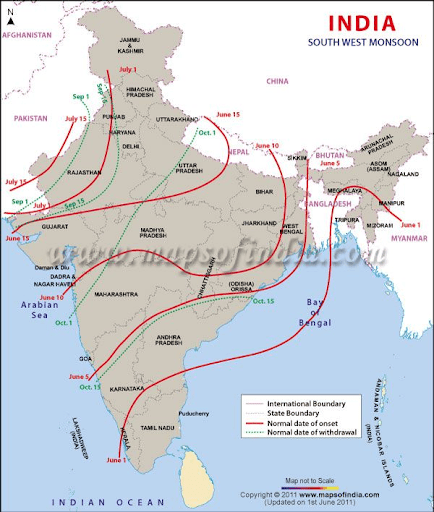
Image Credit: Pinterest
Q2 On the map of India, mark the retreating monsoon in India.
Ans

Image Credit: tlp.iasbaba.com
Q3 On the map of India, mark the seasonal rainfall in India.
Ans

Image Credit:civilsdaily.com
Also See :
Geography Important Questions
- India Size and Location Class 9 Geography Chapter 1 MCQs, Question Answers
- Physical Features of India Class 9 Geography Chapter 2 MCQs, Question Answers
- Drainage Class 9 Geography Chapter 3 MCQs, Question Answers
- Natural Vegetation and Wildlife Class 9 Geography Chapter 5 MCQs, Question Answers
History Important Questions
- The French Revolution Class 9 Chapter 1 Notes, MCQs, Question Answers
- Socialism in Europe and The Russian Revolution Class 9 Chapter 2 Notes, MCQs, Question Answers
- Nazism and The Rise of Hitler Class 9 Chapter 3 Notes, MCQs, Question Answers
- Forest Society and Colonialism Class 9 Chapter 4 Notes, MCQs, Question Answers/a>
- Pastoralists in The Modern World Class 9 Chapter 5 Notes, MCQs, Question Answers
Political Science Important Questions
- What is Democracy? Why Democracy Class 9 Chapter 1 Notes, MCQs, Question Answers
- Constitutional Design Class 9 Chapter 2 Notes, MCQs, Question Answers
- Electoral Politics Class 9 Chapter 3 Notes, MCQs, Question Answers
- Working of Institutions Class 9 Chapter 4 Notes, MCQs, Question Answers
- Democratic Rights Class 9 Chapter 5 Notes, MCQs, Question Answers