CBSE Class 9 Geography Chapter 1 India Size and Location Important Questions and Answers
India Size and Location Class 9 Questions Answers– Given in this post is Class 9 Geography Chapter 1 India Size and Location Questions Answers. We have compiled Important Questions and Answers from the chapter to help the students to understand the types of questions asked in exams. Students can practice Class 9 Geography important questions to understand the subject better and improve their performance in the board exam. The NCERT Solutions Class 9 Social Science (Geography) provided here will also give students an idea about how to write the answers. Check out India Size and Location MCQs
Chapter 1 India Size and Location MCQ Questions Answers
Q1 Which of the following influences the duration of the day and night, as one moves from south to north?
A Longitudinal extent
B Latitudinal extent
C Standard Meridian
D All the above
Ans B Latitudinal extent
Q2 Indian Standard Time or I.S.T. is how many hours ahead or behind G.M.T. or Universal Time?
A 5 hrs 30 min behind G.M.T.
B 15 hrs ahead of G.M.T.
C 5 hrs 30 min ahead of G.M.T.
D None of the above
Ans C 5 hrs 30 min ahead of G.M.T.
Q3 The Standard Meridian of India, 82°30’E passes through which of the following places?
A Kanyakumari in Tamil Nadu
B Walong in Arunachal Pradesh:
C Kachchh in Gujarat
D Mirzapur in Uttar Pradesh
Ans D Mirzapur in Uttar Pradesh
Q4 If the local time at Dwarka (69°01’E) in Gujarat to the west of India is 6 am, what will be the local time at Dibrugarh (94°58’E approximately 95°), in Assam, in the east?
A 4.16 am
B 6 am
C 7.44 am
D 7.44 pm
Ans C 7.44 am
Q5 Both the latitudinal and longitudinal extent of India’s mainland is about 30°. But on looking at the map of India, which of the following alternatives do you observe about India’s size?
A East-west extent appears to be smaller than north-south extent
B East-west extent appears to be larger than north-south extent
C East west and north-south extent appears equal
D North-south extent appears to be smaller than east-west extent
Ans A East-west extent appears to be smaller than north-south extent
Q6 By which geographical feature is India bounded in the north-west, north and north-east?
A Seas
B Lava Plateaus
C Young Fold Mountains
D Sandy Desert
Ans C Young Fold Mountains
Q7 Which of the following figures shows the total area of India’s landmass?
A 2.4 million square km
B 3.28 million square km
C 32.8 million square km
D 3.28 million km
Ans B 3.28 million square km
Q8 What is India’s size with respect to other countries of the world?
A First
B Third
C Fourth
D Seventh
Ans D Seventh
Q9 Which geographical feature bounds India’s mainland south of 22°N latitude?
A Young Fold Mountains
B Sandy Desert
C Lava Plateaus
D Seas and Ocean
Ans D Seas and Ocean
Q10 Which of the following is the western-most longitude of India?
A 97°25’E
B 68°7′E
C 68°7’E
D 82°32’E
Ans B 68°7’E
Q11 Which of the following parallels of latitude divides India into two almost equal parts?
A Equator
B Tropic of Capricorn
C Tropic of Cancer
D Prime Meridian
Ans C Tropic of Cancer
Q12 India achieved multi-faceted socio-economic progress during which of the following periods?
A Since ancient times
B During medieval period
C In the 21st century
D During the last five decades
Ans D During the last five decades
Q13 Which of the following places of India is located on the three seas?
A Port Blair
B Kavaratti
C Kanyakumari
D Kochi
Ans C Kanyakumari
Q14 Which of the following is the longitudinal extent of India?
A 8°4’N and 37°6’N
B 68°7’N and 97°25’E
C 68°7’E and 97°25’W
D 8°4’E and 37°6′E
Ans B 68°7’N and 97°25’E
Q15 Which of the following Union Territories is located along the west coast of India?
A Andaman and Nicobar Islands
B Chandigarh
C Dadra and Nagar Haveli
D Puducherry
Ans C Dadra and Nagar Haveli
Q16 Which of the following is the oldest route of contact between India and other countries of the world?
A Ocean routes
B Maritime contact
C Land routes
D Air routes
Ans C Land routes
Q17 In which of the following places, would you find the least difference in the duration between daytime and night time?
A Kanyakumari
B Leh
C Srinagar
D Itanagar
Ans A Kanyakumari
Q18 Due to which of the following reasons is the Indian Ocean named after India?
A India has a strategic location along the trans-Indian Ocean routes
B No other country has a long coastline on the Indian Ocean as India
C India is centrally located at the head of the Indian Ocean
D All the above
Ans D All the above
Q19 The latitudinal extent of India lies between
A 7° 5′ N and 26° 5′ N
B 8° 4′ N and 37° 6′ N
C 12° 5′ N and 27° 5′ N
D 12° 5′ N and 37° 6′ N
Ans B 8° 4′ N and 37° 6′ N
Q20 Tropic of Cancer passes through which of these states
A Orissa
B Tripura
C Bihar
D Punjab
Ans B Tripura
Q21 Which meridian is fixed as a Standard Meridian of India?
A 82½° E
B 84° E
C 86° E
D 81° E
Ans A 82° E
Q22 What is the position of India in the world in respect to area?
A 8th position
B 7th position
C 6th position
D 2nd position
Ans B 7th position
Q23 Which country among India’s neighbours is the smallest?
A Nepal
B Bhutan
C Sri Lanka
D Bangladesh
Ans B Bhutan
Q24 Which one of the following forms the southernmost tip of the Indian mainland?
A Indira Point
B Kanyakumari
C Palk Strait
D Kavaratti
Ans B Kanyakumari
Q25 India’s total area accounts for what percentage of the geographical area of the world?
A 2.9%
B 3.2%
C 2.4%
D 4.2%
Ans C 2.4%
Q26 India has land boundary of about
A 18,200 km
B 7516.6 km
C 15,200 km
D 2458 km
Ans C 15,200 km
Q27 The neighbouring countries that share their boundaries with India are:
A Pakistan and Afghanistan
B Myanmar and Bangladesh
C China and Nepal
D All the above
Ans D All the above
Q28 Which one of the following straits separates India from Sri Lanka?
A Sunda Strait
B Johor Strait
C Bering Strait
D Palk Strait
Ans D Palk Strait
Q29 A narrow channel of sea separating two land-masses is called:
A Gulf
B Strait
C Isthmus
D Bay
Ans B Strait
Q30 What is the length of the Indian coastline?
A 8716 km
B 7165 km
C 9515 km
D 7516 km
Ans D 7516 km
Q31 The four states which are situated along the Himalayas are:
A Jammu and Kashmir, Himachal Pradesh, Uttarakhand, Arunachal Pradesh
B Gujarat, Maharashtra, Haryana, Rajasthan
C Gujarat, Chhattisgarh, Bihar, Jharkhand
D Bihar, West Bengal, Orissa, Uttar Pradesh
Ans A Jammu and Kashmir, Himachal Pradesh, Uttarakhand, Arunachal Pradesh
Q32 Which one of the following water bodies separate Sri Lanka from India?
A Palk Strait and Gulf of Khambhat
B Palk Strait and Gulf of Mannar
C Gulf of Mannar and 10° Channel
D 10° Channel and Gulf of Khambhat
Ans B Palk Strait and Gulf of Mannar
1 Mark Questions
Q1 Name the group of islands lying in the Arabian sea? (NCERT QUESTION)
Ans Lakshadweep islands.
Q2 Name the countries which are larger than India? (NCERT QUESTION)
Ans Russia, Canada, USA, China, Brazil, and Australia.
Q3 Which island group of India lies to its south-east? (NCERT QUESTION)
Ans Andaman and Nicobar islands.
Q4 Which island countries are our southern neighbors? (NCERT QUESTION)
Ans Sri Lanka and Maldives
Q5 The central location of India at the head of the Indian Ocean is considered of great significance. Why? (NCERT QUESTION)
Ans The trans-Indian Ocean routes which connect the countries of Europe in the West and the countries of East Asia provide a strategic central location to India.
Q6 In which hemisphere does India lie?
Ans India lies in the Northern hemisphere.
Q7 What is the latitudinal extent of India?
OR
What are the degrees of the southernmost latitude of mainland India?
OR
What are the degrees of the northernmost latitude of India?
Ans The latitudinal extent of India is between 8°4′ N (southernmost) and 37°6’ N and (northernmost) latitude.
Q8 What is the longitudinal extent of India? Or What are the degrees of the easternmost and westernmost longitude of India?
Ans The longitudinal extent of India is 68°7′ E (westernmost) to 97°25′ E (easternmost) longitude.
Q9 Name the parallel of latitude which divides India roughly into two equal halves.
Ans The parallel of latitude which roughly divide India into two equal halves is the Tropic of Cancer (23° 30′ N).
Q10 Name the two seas located around India.
Ans The two seas located around India are the Arabian Sea in the west and the Bay of Bengal in the east.
Q11 What is the southernmost point of the Union of India?
Answer: Southernmost point of the Union of India is Indira Point.
Q12 In which year did ‘Indira Point’ submerged under water due to the tsunami?
Ans In 2004 ‘Indira Point’ got submerged under the sea water.
Q13 What is the total area of the Indian landmass?
Ans The landmass of India has an area of 3.28 million square km. It is 2.4% of the total area of the world.
Q14 What is the size of India among the countries of the world?
Ans India is the seventh largest country in the world.
Q15 What is the total land frontier of India?
Ans The total land frontier of India is 15,200 km.
Q16 Give the total length of the Indian coastline including the Indian islands.
Ans The total length of the Indian coastline is 7,516.6 km.
Q17 In which direction India is bound by young fold mountains?
Ans In the north, northwest and northeast direction, India is bound by young fold mountains.
Q18 Why is the north-south extent of India larger than east-west extent even though the latitudinal and longitudinal extent in degrees is of the same value?
Ans This is because the distance between two latitudes is always 111 km i.e. always same whereas between two longitudes, it is the maximum at the equator and decreases towards the poles.
Q19 What is the time lag between Gujarat and Arunachal Pradesh?
Ans The time lag between Gujarat and Arunachal Pradesh is 2 hours.
Q20 Why has 82°30′ been selected as the standard meridian of India?
Ans 82°30′ E has been selected as the standard meridian of India because it passes through the centre of India, i.e. Mirzapur in Uttar Pradesh.
Q21 Which route connects countries of Europe in the west to the countries of east Asia?
Ans The trans Indian Ocean route.
Q22 In which year the Suez Canal opened?
Ans Suez Canal opened up in 1869.
Q23 What is the significance of the Suez Canal?
Ans With the Suez Canal, India’s distance from Europe has been reduced by 7,000 km.
Q24 What is the total north-south extent of India in km?
Ans The north-south extent of India in kilometers is 3,214 km.
Q25 What is the total east-west extent of India in km?
Ans The total east-west extent of India is 2,933 km.
Q26 How had India kept her relationship with the world in ancient times?
Ans Passes in the mountains of the Himalayas provided passages to the ancient travellers while the oceans restricted this as people were afraid to travel by oceans.
Q27 Which ideas of India could reach the world?
Ans The ideas of the Upanishads and the Ramayana, the stories of Panchtantra, the Indian numerals, decimal system could reach many parts of the world.
Q28 Which commodities were exported from India?
Ans The spices, muslin cloth and many other commodities were exported from India.
Q29 From which regions and styles India got influenced in ancient times?
Ans India got influenced from greek sculpture, the architectural styles of dome and minarets from west Asia in the ancient times.
Q30 Which is the largest and smallest state of India area wise?
Ans The largest state is Rajasthan and the smallest state is Goa.
Q31 Name the states of India which do not have an international border or lie on the coast.
Ans The states are Madhya Pradesh, Chhattisgarh, Haryana and Jharkhand.
Q32 Name the states of India which have a common border with Pakistan.
Ans The states are Gujarat, Rajasthan, Punjab and Jammu and Kashmir.
Q33 Name the states of India which have a common border with China.
Ans The states are Jammu and Kashmir, Himachal Pradesh, Uttarakhand, Sikkim and Arunachal Pradesh.
Q34 Name the states of India which have a common border with Myanmar.
Ans The states are Arunachal Pradesh, Nagaland, Manipur, Mizoram.
Q35 Name the countries which share borders with India.
Ans The countries are Pakistan and Afghanistan in the northwest, China (Tibet), Nepal and Bhutan in the north, Myanmar and Bangladesh in the east.
Q36 Which two island countries are India’s neighbours?
Ans Sri Lanka and Maldives are the two island countries.
Q37 Name the two water bodies which separate India from Sri Lanka.
Ans The two water bodies that separate India are Palk Strait and the Gulf of Mannar.
Q38 Mention the types of states in India present before 1947.
Ans The two types of states in India were:
(a) the provinces
(b) the princely states.
Q39 Who ruled the princely states?
Ans Princely states were ruled by the local hereditary rulers.
Q40 Name the country that has a common land frontier with the states of Uttarakhand, Uttar Pradesh, Bihar, West Bengal and Sikkim.
Ans The country is Nepal.
Q41 Name the states through which the Tropic of Cancer passes.
Ans Gujarat, Rajasthan, Madhya Pradesh, Chhattisgarh, Jharkhand, West Bengal, Tripura and Mizoram.
Q42 Name the Union Territories of India.
Ans The Union Territories are Delhi, Chandigarh, Andaman and Nicobar, Lakshadweep, Daman and Diu, Dadra and Nagar Haveli, Puducherry.
Q43 With which country Jammu and Kashmir, Punjab, Rajasthan and Gujarat share an international boundary?
Ans The country is Pakistan.
Q44 Name the states of India which lie along the eastern coast of India from North to South.
Ans The states lying along the eastern coast are West Bengal, Odisha, Andhra Pradesh and Tamil Nadu.
Q45 Name the two states of India which are parts of the Indian desert.
Ans Gujarat and Rajasthan are parts of the Indian Desert.
Assertion-reason based questions:
Q1 Assertion (A): The Southernmost point of the Indian Union, ‘Indira Point’, got submerged under the sea water in 2004.
Reason (R): In 2004 Indian Islands and coastal areas were hit by a huge Tsunami.
Options:
- Both A and R are true and R is the correct explanation of A.
- Both A and R are true but R is not the correct explanation of A.
- A is true but R is false.
- A is false but R is true.
Ans A. Both A and R are true and R is the correct explanation of A.
The 2004 Indian Ocean earthquake and Tsunami occurred on 26th December, 2004, with an epicenter off the coast of Northern Sumatra, Indonesia. It was an under-sea earthquake with a magnitude of 9%. This quake triggered the tsunami (a series of immense ocean waves), which reached out across the Indian Ocean, devastating coastal areas as far away as East Africa. Indira Point, the Southernmost point of Indian Union, also got submerged under the seawater due to this tsunami.
Q2 Assertion (A): India is bounded by young fold mountains in the North-West, North and North-East.
Reason (R): The Himalayas lie in the Northern part of India.
Options:
- Both A and R are true and R is the correct explanation of A.
- Both A and R are true but R is not the correct explanation of A.
- A is true but R is false.
- A is false but R is true.
Ans A. Both A and R are true and R is the correct explanation of A.
The Himalayas lie on the Northern borders of the Indian subcontinent. These are young fold mountains which form the highest and the rugged mountains in the world.
Q3 Assertion (A): The latitudinal and longitudinal extent of the mainland is about 30° but the East-West extent appears smaller than the North-South extent.
Reason (R): The North-South distance of India is 3214 km.
Options:
- Both A and R are true and R is the correct explanation of A.
- Both A and R are true but R is not the correct explanation of A.
- A is true but R is false.
- A is false but R is true.
Ans B. Both A and R are true but R is not the correct explanation of A.
The latitudes are equidistant from each other but distance between longitudes decreases as one moves from equator to poles. Thus, in spite of having the same latitudinal and longitudinal extent, (30°), the East-West extent of India appears smaller than its North-South extent.
Q4 Assertion (A): The latitudinal extent influences the duration of day and night as one moves from South to North.
Reason (R): Sun rays fall directly on the places located on the equator while the fall slanting towards the poles. Thus, as the latitudes increase, the chances of change in day and night from place to place increases.
Options:
- Both A and R are true and R is the correct explanation of A.
- Both A and R are true but R is not the correct explanation of A.
- A is true but R is false.
- A is false but R is true.
Ans A. Both A and R are true and R is the correct explanation of A.
The sun rays fall directly on the places located on the equator while these fall slanting toward the poles. Thus, as the latitudes increase, the chances of change in day and night from place to place increases. As India lies close to the equator, so, when one moves from South (near the equator) to North the duration of day and night changes.
Q5 Assertion (A): India has 28 States and 8 Union Territories.
Reason (R): As of 2019, Jammu and Kashmir and Ladakh became two different Union Territories and as of 2020, Dadra and Nagar Haveli and Daman and Diu became a single Union Territory of India.
Options:
- Both A and R are true and R is the correct explanation of A.
- Both A and R are true but R is not the correct explanation of A.
- A is true but R is false.
- A is false but R is true.
Ans A. Both A and R are true and R is the correct explanation of A.
India is a federal union comprising 28 States and 8 Union Territories for a total of 36 entities. As per the year 2019, Jammu and Kashmir and Ladakh became two different Union Territories and as per 2020, Dadra and Nagar Haveli and Daman and Diu became a single Union Territory of India.
Fill in the blanks in the following:
Q1 The total length of the coastline of the mainland including Andaman and Nicobar and Lakshadweep is _________ .
Ans 7,516.6 km
Q2 The neighbouring countries that share their boundaries with India are _________ .
Ans Pakistan, Afghanistan, Myanmar, Bangladesh, China, Nepal and Bhutan.
Q3 The longitudinal extent of India is ____________.
Ans 68°7’E to 97°25’E
Q4 The latitudinal extent of India is ____________.
Ans 8°4’N and 37°6’N
Q5 ________ is the smallest state in India.
Ans Goa
Q6 The north-south extent of India is about _________ .
Ans 3,214 km
Q7 __________ does not share any international boundary.
Ans Madhya Pradesh
Q8 _________ canal has reduced India’s distance from Europe by 7,000 km.
Ans Suez
Q9 ______________ influences the duration of the day and night as one moves from south to north.
Ans Latitudinal extent
Q10 _________ ocean has been named after a country ?
Ans Indian
Q11 A narrow channel of sea that connects two layer bodies of water is called a _________.
Ans strait
Q12 China is the _________ largest country in the world.
Ans Fourth
Q13 From Gujarat to Arunachal Pradesh, the time lag is _________.
Ans 2 hours
Q14 The southernmost point of the Indian mainland is _________.
Ans Kanyakumari
Q15 Suez Canal was opened in ________.
Ans 1869
Q16 India’s total area accounts for about _______ of the total geographical area of the world.
Ans 2.4%
Q17 _________ is the neighbouring country of India as an island.
Ans Maldives.
Q18 Before 1947, there were two types of states in India such as the _____________.
Ans Provinces and Princely States.
Q19 _________ is the largest state (area-wise) of India.
Ans Rajasthan.
Q20 Indira Point got submerged under the sea water in __________ during the Tsunami.
Ans 2004
3 Mark Questions
Q1 Write the size and extent of India.
Ans 1. India is the 7th largest country in the world. It has an area of 3.28 million square km. It accounts for 2.4% of the world’s total area.
- India has a land frontier of 15,200 km.
- India has a coastline of 7516.6 km including the Andaman and Nicobar islands and the Lakshadweep islands.
Q2 Explain why 82°30′ E an odd value has been chosen as the standard meridian of India.
OR
The sun rises two hours earlier in Arunachal Pradesh as compared to Gujarat in the west but the watches show the same time. How does this happen? (NCERT QUESTION)
Ans 1. The odd value has been chosen as the standard meridian because the longitudinal extent of India is 68°7′ E to 97°25′ E and this meridian passes through the centre of India. It passes through Mirzapur i.e. the centre of India.
- Then there is an understanding among the countries of the world that the degrees of the meridian should be divisible by 712 i,e. 82° 30′ E.
- This enables us to overcome the difference of 2 hours of time between Arunachal Pradesh and Gujarat. The time is Indian Standard Time.
Q3 Why is the difference between the durations of day and night hardly felt at Kanyakumari but not so in Kashmir?
Ans 1. The difference in the durations of day and night and Kanyakumari and Kashmir are respectively due to their latitudinal locations.
- Kanyakumari is located closer to the equator and experiences a maximum difference of 45 minutes between day and night.
- However, Kashmir lies further away from the equator and experiences a significant gap between the duration of day and night that can extend to as much as 3-5 hours.
Q4 What is a subcontinent? Name the countries that constitute the Indian subcontinent. How is India different from other countries of Asia?
Ans 1. A subcontinent is a distinctive geographical unit which stands out distinctively from the rest of the region because of its large size, varied climates, varied relief etc.
- Countries that make up the Indian subcontinent are – India at the centre, Pakistan in the west, Nepal and China (Tibet) in the north, Bhutan and Bangladesh in the east.
- India is different from other countries of Asia regarding climate, vegetation and culture.
Q5 Justify the naming of the Indian Ocean after India.
Ans India ocean is named after India because:
- India has a long coastline on the Indian Ocean.
- India has a central location between east and west Asia.
- India’s southernmost extension, the Deccan Peninsula, protrudes into the Indian Ocean which makes it significant to international trade done through the Indian Ocean.
- India was the favourite destination of the traders of the world.
Q6 What do you know about India and her neighbours?
Ans 1. India occupies an important strategic position in south-east Asia. India has 29 states, 6 Union Territories and one National Capital Territory.
- India shares her land borders with Pakistan and Afghanistan in the north-west, China (Tibet), Nepal and Bhutan in the north, and Myanmar and Bangladesh in the east. Our southern neighbours across the sea consists of two island countries i.e. Sri Lanka and Maldives.
- Sri Lanka is separated from India by the Palk Strait and Gulf of Mannar while Maldives islands are situated to the south of the Lakshadweep islands.
Q7 India’s land routes have been important since ancient times. Explain.
Ans 1. India’s contacts with the outside world have continued through the ages, but her relationships through the land routes are much older than her maritime contacts.
- The various passes across the mountains in the north have provided passages to the ancient travellers. These routes (Kyber and Bolan pass) across the mountains have contributed to the exchange of ideas and commodities since ancient times.
- The ideas of Upanishads and the Ramayana, the stories of Panchatantra, the Indian numerals, the decimal system could reach many parts of the world through the land routes. The spices and muslin cloth along with other commodities were taken from India to other countries. The Greek sculpture and the architectural style of domes and minarets from west Asia can be seen in many parts of our country. This is the result of the exchange of commodities and ideas movement of people.
4 Mark Questions
Q1 Read the extract given below and answer the questions that follow:
India is a vast country. Lying entirely in the Northern hemisphere. The mainland extends between latitudes 8°4’N and 37°6’N and longitudes 68°7E and 97°25 E. The Tropic of Cancer (23° 30°N) divides the country into almost two equal parts. To the southeast and southwest of the mainland lie the Andaman and Nicobar Islands and the Lakshadweep islands in the Bay of Bengal and the Arabian Sea respectively. Find out the extent of these groups of islands from your atlas. The land mass of India has an area of 3.28 million square km. India’s total area accounts for about 2.4 percent of the total geographical area of the world. India is the seventh largest country in the world. Note that the latitudinal and longitudinal extent of the mainland is about 30°. Despite this fact, the east-west extent appears to be smaller than the north-south extent.
- What is the Latitudinal extent of India? (1)
A 8°4’E and 37°6W
B 8*4°N and 37°6’S
C 8°4’N and 37 6’N
D 8°4’5 and 37 6’s
Ans C 8°4’N and 37 6’N
- What is the Longitudinal extent of India? (1)
A 68°7E and 97°25’E
B 68 7W and 97°25’E
C 68 7E and 97°25’W
D 68 7N and 97°25’S
Ans A 68°7E and 97°25’E
- Why does the east-west extent of India appear to be smaller than the north-south extent? (2)
Ans The distance between lines of latitude remains the same from the equator to the poles. But, the distance between the lines of longitudes decreases as we move towards the poles. India is slightly above the equator. So, the lines of longitude come nearer and the East-West distance becomes less than the North-South distance.
Q2 Read the extract given below and answer the questions that follow:
India is bounded by the young fold mountains in the northwest, north, and northeast. South of about 22 north latitude, it begins to taper and extends towards the Indian Ocean, dividing it into two seas, the Arabian Sea on the west and the Bay of Bengal on its east. Note that the latitudinal and longitudinal extent of the mainland is about 30″ From Gujarat to Arunachal Pradesh, there is a time lag of two hours. Hence, time along the Standard Meridian of India passing through Mirzapur (in Uttar Pradesh) is taken as the Indian standard time for the whole country. The latitudinal extent influences the duration of day and night, as one moves from south to north.
- Name the young fold mountains that bound India from the northwest, north, and northeast. (1)
A Aravalis
B Himalayas
C Karakoram
D Purvanchal hills.
Ans B Himalayas
- If the time at the easternmost longitude of India is 11:30 P.M. What will be the time at the westernmost longitude of India? (1)
A 1:30 A.M.
B 1:30 PM.
C 9:30 A.M.
D 9:30 P.M.
Ans D 9:30 P.M.
- Which Longitude is considered the Indian Standard Time meridian for India and why? (2)
Ans 82°30’E Longitude is considered the Indian Standard Time meridian for India. This is because India’s Longitudinal extent is 68°7’E and 97°25′E. It means almost 30 longitudes pass through India. We know that there is a time difference of 4 minutes between two longitudes. In such a case time at every place in India will be different and will create a lot of confusion. Therefore, 82°30’E Longitude which passes through the center of India has been considered the Indian Standard Time meridian for India to avoid such confusion.
Q3 Read the extract given below and answer the questions that follow:
The Indian landmass has a central location between East and West Asia. India is a southward extension of the Asian continent. The trans-Indian Ocean routes, which connect the countries of Europe in the West and the countries of East Asia, provide a strategic central location for India. Note that the Deccan Peninsula protrudes into the Indian Ocean, thus helping India to establish close contact with West Asia, Africa, and Euro from the western coast and with Southeast and East Asia from the eastern coast. No other country has a long coastline on the Indian Ocean as India has and it is India’s eminent position in the Indian Ocean, which justifies the naming of an Ocean after it.
- What provides a strategic central location for India? (1)
Ans The trans-Indian Ocean routes, which connect the countries of Europe in the West and the countries of East Asia, provide a strategic central location for India.
- How did India benefit from its long coastline? (1)
Ans The Deccan Peninsula protrudes into the Indian Ocean, thus helping India to establish close contact with West Asia, Africa, and Europe from the western coast and with Southeast and East Asia from the eastern coast. No other country has a long coastline on the Indian Ocean.
- Give two reasons which justify the naming of an Ocean after India. (2)
Ans Two reasons which justify the naming of an Ocean after India are:
- India’s eminent position in the Indian Ocean
- No other country has a long coastline on the Indian Ocean as India has.
Q4 Read the extract given below and answer the questions that follow:
India’s contacts with the World have continued through ages but her relationships through the land routes are much older than her maritime contacts. The various passes across the mountains in the north have provided passages to the ancient travelers, while the oceans restricted such interaction for a long time. These routes have contributed to the exchange of ideas and commodities since ancient times. The ideas of the Upanishads and the Ramayana, the stories of Panchtantra, the Indian numerals, and the decimal system thus could reach many parts of the world. The spices, muslin, and other merchandise were taken from India to different countries. On the other hand, the influence of Greek sculpture, and the architectural styles of domes and minarets from West Asia can be seen in different parts of our country.
- Do you think the ocean routes helped India to establish close contact with the world during ancient times? (1)
Ans No, it is the land routes and the passes across the mountains that helped India to establish close contact with the world during ancient times.
- What is India’s contribution to the world? (1)
Ans India has contributed the ideas of the Upanishads and the Ramayana, the stories of Panchtantra, the Indian numerals, and the decimal system along with spices and muslin to the world.
- What India has learned from other countries of the world? (2)
Ans a) Greek sculpture, and
- b) the architectural styles of domes and minarets.
Q5 Read the extract given below and answer the questions that follow:
India occupies an important strategic position in South Asia. India has 28 states and Eight Union Territories India shares its land boundaries with Pakistan and Afghanistan in the northwest, China (Tibet), Nepal and Bhutan in the north, and Myanmar and Bangladesh in the east. Our southern neighbors across the sea consist of the two island countries, namely Sri Lanka and the Maldives. Sri Lanka is separated from India by a narrow channel of sea formed by the Palk Strait and the Gulf of Mannar, while the Maldives Islands are situated to the south of the Lakshadweep Islands.
- Name a newly formed state and union territory of India? (1)
Ans State- Telangana
Union Territory- Ladakh
- Sri Lanka and the Maldives lie in which sea/oceans? (1)
Ans Both lie in the Indian Ocean.
- What is the old name of Myanmar? (1)
Ans Burma is the old name of Myanmar.
- Which Indian states share borders with Myanmar? (1)
Ans Arunachal Pradesh, Nagaland, Manipur, and Mizoram are the Indian states that share borders with Myanmar.
5 Mark Questions
Q1 Why are Ahmedabad and Kolkata able to see the noon seen exactly overhead twice a year but not Delhi?
Ans The sun’s apparent movement towards north and south of the equator is within two tropics.
- All the places located within the tropics have overhead sun twice a year.
- Both Ahmedabad and Kolkata lie to the south of the Tropic of Cancer. That is why these two stations see the noon sun overhead twice a year.
- Delhi is located at 29°N latitude much to the north of the Tropic of Cancer.
- The sun’s rays are near overhead in subtropical zones. It will never see noon sun overhead, at any time of the year.
Q2 India occupies an important strategic position in south Asia. Discuss.
Ans 1. The Indian landmass has a central location between east and west Asia. India is a southward extension of the Asian continent.
- The trans Indian Ocean routes which connect the countries of Europe in the west and the countries of east Asia provide a strategic central location to India.
- The part that is attached to the Asian continent connects India through the land routes and mountain passes to the various countries lying to its north, west and east.
- The Deccan Peninsula protrudes into the Indian Ocean, thus helping India to establish close contact with west Asia, Africa and Europe from the western coast and southeast and east Asia from the eastern coast.
Q3 Describe how the geographical features of India have fostered unity and homogeneity in Indian society.
Ans India has a distinct physical and cultural identity: India’s unity and homogeneity have been enabled by its physical diversity i.e., physical features.
- The lofty mountains in the north which run east-west for thousands of kilometers. They provide a natural wall against all possible intrusions. It gives India an intact structure.
- The southern part of India is surrounded by the seas and oceans on the sides. These physical features have also ensured that the people from outside could enter India only through well defended routes through sea or passes in the mountains.
- Standard meridian 82’30” has been taken as local time all over India providing uniformity.
- Rivers and their tributaries provide irrigation facilities throughout the country to bring uniform development.
- Monsoons foster unity. Many festivals are associated with it. Apart from that agricultural and domestic needs are also met by monsoons.
Thus, by adopting new norms and values and accepting as their own, unity and homogeneity of India has been promoted.
Map Based Questions
Q1 Locate and label the Indian state and their capitals on the following map of India.
Ans
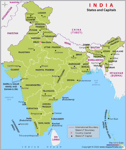
Image Credit: mapsofindia.com
Q2 On the map of India, locate and label the following:
- Tropic of cancer
- Standard meridian with degrees
Ans
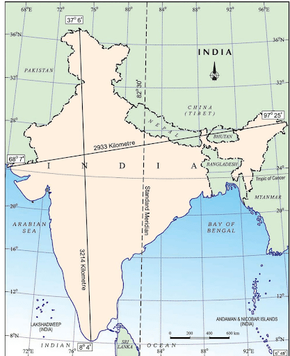
Image Credit: NCERT Textbook Class 9 geography Contemporary India-I
Q3 On the map of India, locate and label the union territories.
Ans
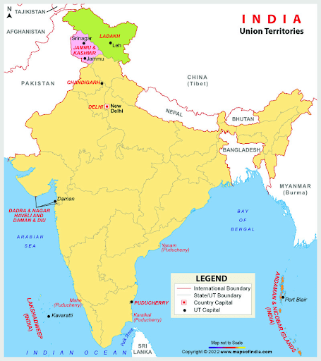
Image Credit: mapsofindia.com
Also See :
Geography Important Questions
- Physical Features of India Class 9 Geography Chapter 2 MCQs, Question Answers
- Drainage Class 9 Geography Chapter 3 MCQs, Question Answers
- Climate Class 9 Geography Chapter 4 MCQs, Question Answers
- Natural Vegetation and Wildlife Class 9 Geography Chapter 5 MCQs, Question Answers
History Important Questions
- The French Revolution Class 9 Chapter 1 Notes, MCQs, Question Answers
- Socialism in Europe and The Russian Revolution Class 9 Chapter 2 Notes, MCQs, Question Answers
- Nazism and The Rise of Hitler Class 9 Chapter 3 Notes, MCQs, Question Answers
- Forest Society and Colonialism Class 9 Chapter 4 Notes, MCQs, Question Answers/a>
- Pastoralists in The Modern World Class 9 Chapter 5 Notes, MCQs, Question Answers
Political Science Important Questions
- What is Democracy? Why Democracy Class 9 Chapter 1 Notes, MCQs, Question Answers
- Constitutional Design Class 9 Chapter 2 Notes, MCQs, Question Answers
- Electoral Politics Class 9 Chapter 3 Notes, MCQs, Question Answers
- Working of Institutions Class 9 Chapter 4 Notes, MCQs, Question Answers
- Democratic Rights Class 9 Chapter 5 Notes, MCQs, Question Answers