NCERT Solutions for Class 10 Geography Chapter 7 Lifelines of Indian Economy – Important Questions
Lifelines of National Economy Important Question Answers – Given in this post is NCERT Solutions for Class 10 Geography Chapter 7 Lifelines Of National Economy. The important questions we have compiled will help the students to brush up on their knowledge about the subject. Students can practice Class 10 Geography important questions to understand the subject better and improve their performance in the board exam. The NCERT solutions provided here will also give students an idea about how to write the answers.
Lifelines of National Economy – MCQ Based Questions
Q1 East-West Corridor connecting Silcher in _________ and Porbander in Gujarat are part of the Golden Quadrilateral Highways.
A Assam
B Arunachal Pradesh
C Manipur
D Sikkim
Ans A Assam
Q2 The major objective of these Super Highways is to reduce the time and distance between the megacities of India. These highway projects are being implemented by the ____________.
A National Highway Authority of India (NHAI)
B State Highway Authority of India
C Public Works Department
D All of the above
Ans A National Highway Authority of India (NHAI)
Q3 The historical Sher-Shah Suri Marg is called National Highway No.1, between Delhi and ___________.
A Jalandhar
B Chandigarh
C Ludhiana
D Amritsar
Ans D Amritsar
Q4 Roads linking a state capital with different district headquarters are known as ___________.
A National Highways
B State Highways
C Expressways
D Super Highways
Ans B State Highways
Q5 District Roads connect the district headquarters with other places of the district. These roads are maintained by the ___________.
A Zila Parishad
B State Government
C Central Government
D Village Panchayat
Ans A Zila Parishad
Q6 ____________ is a Government of India undertaking which constructs and maintains roads in the bordering areas of the country.
A Public Works Department
B Border Roads Organisation
C National Highway Authority of India
D None of the above
Ans B Border Roads Organisation
Q7 Petroleum and Petroleum products constitute ___________ of the total commodities imported to India.
A 5.2 percent
B 9.4 percent
C 2.7 percent
D 28.6 percent
Ans D 28.6 percent
Q8 Border Roads Organisation (BRO) was established in ________ for the development of the roads of strategic importance in the northern and northeastern border areas.
A 1965
B 1955
C 1960
D 1970
Ans C 1960
Q9 The length of road per __________ of area is known as the density of roads.
A 100 sq. km
B 300 sq. km
C 200 sq. km
D 500 sq. km
Ans A 100 sq. km
Q10 Density of all roads varies from only 12.14 km in Jammu and Kashmir to 517.77 km in __________, as on 31st March 2011.
A Andhra Pradesh
B Karnataka
C Maharashtra
D Kerala
Ans D Kerala
Q11 ___________ is the largest public sector undertaking in India.
A National Highways Authority of India (NHAI)
B Steel Authority of India Limited (SAIL)
C National Thermal Power Corporation (NTPC)
D Indian Railways
Ans D Indian Railways
Q12 The first train in India steamed off from _________ to _________ in 1853, covering a distance of 34 km.
A Mumbai to Thane
B Mumbai to Surat
C Delhi to Lucknow
D Delhi to Mumbai
Ans A Mumbai to Thane
Q13 The Indian Railway network runs on multiple gauge operations, __________ has the maximum total track in kilometres.
A Broad Gauge
B Metre Gauge
C Narrow Gauge
D None of the above
Ans A Broad Gauge
Q14 From Salaya in Gujarat to ___________ in Punjab, via Viramgam, Mathura, Delhi and Sonipat is one of the three important networks of pipeline transportation in the country.
A Jalandhar
B Ludhiana
C Chandigarh
D Amritsar
Ans A Jalandhar
Q15 From __________ in Gujarat to Jagdishpur in Uttar Pradesh, via Vijaipur in Madhya Pradesh is one of the three important networks of pipeline transportation in the country.
A Surat
B Ahmedabad
C Hazira
D Porbandar
Ans C Hazira
Q16 National Waterway No.2 is between Sadiya and _____________.
A Dhubri
B Udyogamandal
C Haldia
D Champakkara
Ans A Dhubri
Q17 95 percent of India’s trade in volume and 68 percent of India’s trade in terms of value is moved by _____.
A Railways
B Sea
C Roadways
D Airways
Ans B Sea
Q18 _________ port was the first port developed soon after Independence to ease the volume of trade on the Mumbai port, in the wake of the loss of Karachi port to Pakistan after the Partition.
A Surat
B Porbandar
C Okha
D Kandla
Ans D Kandla
Q19 ___________ is the premier iron ore exporting port of India.
A Marmagao port
B Mumbai port
C Mangalore port
D Chennai port
Ans A Marmagao port
Q20 ________ port is the deepest landlocked and well-protected port of India.
A Vishakhapatnam
B Kochi
C Tuticorin
D Paradip
Ans A Vishakhapatnam
Q21 Which of the following extreme locations are connected by the east-west corridor? (NCERT QUESTION)
A Mumbai-Nagpur
B Mumbai and Kolkata
C Silchar and Porbandar
D Nagpur and Siligudi
Ans C Silchar and Porbandar
Q22 Which mode of transport reduces trans-shipment losses and delay? (NCERT QUESTION)
A Railways
B Roadways
C Pipelines
D Waterways
Ans C Pipelines
Q23 Which one of the following States is not connected by H.V.J. pipeline? (NCERT QUESTION)
A Madhya Pradesh
B Maharashtra
C Gujarat
D Uttar Pradesh
Ans B Maharashtra
Q24 Which one of the following ports is the deepest land-locked and well protected port along the East coast? (NCERT QUESTION)
A Chennai
B Paradip
C Tuticorin
D Vishakhapatnam
Ans D Vishakhapatnam
Q25 Which one of the following is the most important mode of transportation in India? (NCERT QUESTION)
A Pipeline
B Railways
C Roadways
D Airways
Ans C Roadways
Q26 Which one of the following terms is used to describe trade between two or more countries? (NCERT QUESTION)
A Internal trade
B International trade
C External trade
D Local trade
Ans B International trade
Related – Class 10 History, Geography and Political Science Important Questions
Lifelines of National Economy – 1 Mark Questions
Q1 Name the Northern terminal of the North-south corridor. (NCERT QUESTION)
Ans Srinagar
Q2 Name the National Highway No. 1. (NCERT QUESTION)
Ans Delhi-Dankuni (near Kolkata) (it’s the port of the Golden quadrilateral super highways).
Q3 Name the headquarters of the southern railway zone. (NCERT QUESTION)
Ans Chennai central
Q4 Name the rail gauge with a track width of 1.676 m. (NCERT QUESTION)
Ans Broad gauge
Q5 Name the southern terminal of National Highway No. 7. (NCERT QUESTION)
Ans Tuticorin
Q6 Name a Riverine Port. (NCERT QUESTION)
Ans Port of Kolkata
Q7 Name the Busiest railway junction in Northern India. (NCERT QUESTION)
Ans Mughal Sarai
Q7 Why do we need transportation?
Ans Goods and services do not move from their supply locations to demand locations on their The movement of these goods and services necessitates the need for transport. own.
Q8 Why is an efficient means of transport considered as a pre-requisite for fast development?
Ans The pace of development of a country depends upon the production of goods and services as well as their movement over space. Therefore, an efficient means of transport is a pre-requisite for fast development.
Q9 How are transport, communication and trade complimentary to each other?
Ans For a long time, trade and transport were restricted to a limited space. Today the world has been converted into a large village with the help of efficient and fast moving transport. Transport has been able to achieve this with the help of an equally developed communication system.
Q10 What has contributed to the socio-economic progress of India?
Ans Today, India is well linked with the rest of the world despite its vast size, diversity and linguistic and socio-cultural plurality. Railways, airways, waterways, newspaper, radio, television, cinema, internet, etc., have been contributing to its socio-economic progress in many ways.
Q11 What is the extent of the North-South Corridor of India?
Ans North-South Corridor links Srinagar (Jammu and Kashmir) to Kanyakumari (Tamil Nadu).
Q12 Name the southern terminal station of the ‘North-South Corridor’.
Ans Kanyakumari
Q13 Name the river which is related to “National Waterways’ No. 1. (CBSE 2017)
Ans Ganga
Q14 How is the East-West Corridor connected?
Ans East-West Corridor is connecting Silchar (Assam) in the East to Porbandar (Gujarat) in the west.
Q15 What do you know about the Golden Quadrilateral?
Ans The government has launched a major road development project linking Delhi-Kolkata, Chennai, Mumbai and Delhi by six lane super highway. It is looked after by the National Highway Authority of India.
Q16 Who looks after the National Highways of India?
Ans National highways link extreme parts of the country. These are the primary road systems and are laid and maintained by Central Public Works Department (CPWD).
Q17 What do you know about National Highway 1?
Ans The historical Sher Shah Suri Marg is called National Highway 1. It is located between Delhi and Amritsar.
Q18 Which places are linked by National Highway 2 and 3?
Ans National Highway 2 links Delhi to Kolkata and National Highway 3 links Gwalior to Jhansi.
Q19 What do you know about National Highway 7?
Ans National Highway 7 is the longest and traverses 2,369 kms between Varanasi and Kanyakumari via Jabalpur, Nagpur, Hyderabad, Bangalore and Madurai.
Q20 How are Mumbai and Delhi connected by road?
Ans Delhi and Mumbai are well connected by National Highway
Q21 What do you know about National Highway 15?
Ans National Highway 15 covers most of Rajasthan.
Q22 Who looks after State Highways of India? (CBSE 2017)
Ans State Highways are constructed and maintained by the State Public Works Department (PWD) in states and union territories.
Q23 Name the river related to National Waterways No. 2.
Ans The river related to National Waterway No.2 is River ‘Brahmaputra’.
Q24 What do you know about District Roads?
Ans District Roads connect the district headquarters with other places of the district. These roads are maintained by Zila Parishad.
Q25 What does ‘Road Density’ mean?
Ans The length of road per 100 sq. kms of area is known as density of roads.
Q26 What is the status of road density in India?
Ans Distribution of roads is not uniform in the country. Density of all roads varies from only 10 km in Jammu and Kashmir to 375 kms in Kerala with National Average of 75 km (1996-97).
Q27 Why are railways considered a principal mode of transport in India.
Ans Railways are the principal mode of transportation for freight and passengers in India. Railway also make it possible to conduct multifarious activities like business, sightseeing, pilgrimage along with transportation of goods over longer distances.
Q28 When was the first train in India launched?
Ans The first train steamed off from Mumbai to Thane in 1853, covering a distance of 34 kms.
Q29 What is the network of railways in the northern plains?
Ans The northern plains with their vast level land, high population density and rich agricultural resources provided the most favourable condition for their growth.
Q30 What is the status of railways in hilly tracts?
Ans In the hilly terrains of the peninsular region, railway tracts are laid through low hills, gaps or tunnels.
Q31 How are Konkan railways materialised?
Ans In recent times, the development of the Konkan railway along the west coast has facilitated the movement of passengers and goods in this most important economic region of India. It has also faced a number of problems such as sinking of track in some stretches and landslides.
Q32 What is a new arrival on the transportation map of India? (CBSE SAMPLE PAPER 2016)
Ans Pipeline transport network is a new arrival on the transportation map of India to transport liquids as well as solids in slurry form.
Q33 What is the significance of waterways?
Ans Waterways are the cheapest means of transportation. They are the most suitable transportation system for carrying heavy and bulky goods. It is a fuel efficient and environment friendly mode of transport.
Q34 Where is National Waterway 3 located?
Ans The West-Coast Canal in Kerala (Kottapuram-Kollam, Udyogamandal and Champakara canals) forms the National Waterway 3.
Q35 How many ports do we have in India?
Ans With a long coastline of 7516.6 kms, India is dotted with 12 major and 181 medium and minor ports.
Q36 Name the first sea port developed after independence on the western coast of India. (CBSE 2017)
Ans First Sea Port developed after independence-Kandla
Q37 Write about the port developed in place of Karachi port, which has gone to Pakistan.
Ans Kandla in Kutch was the first port developed soon after independence to ease the volume of trade on the Mumbai port in the wake of loss of Karachi port to Pakistan after partition.
Q38 What are the benefits of Kandla port today?
Ans Kandla is a tidal port. It caters to the convenient handling of exports and imports of highly productive granary and industrial belt stretching across the states of Jammu and Kashmir. Himachal Pradesh, Punjab, Haryana, Rajasthan and Gujarat.
Q39 What is the contribution of two ports of Mumbai?
Ans Mumbai is the biggest port with a spacious natural and well-sheltered harbors. The Jawaharlal Nehru Port was planned with a view to decongest the Mumbai Port and serve as a hub port for this region.
Q40 What is the role of Goa port to the Economy of India?
Ans Marmagao Port of Goa is the premier iron ore exporting port of the country. This post accounts for about 50% of India’s iron-ore exports.
Q41 Name the State related to National Waterways No. 3. (CBSE 2017)
Ans State related to National Waterways No. 3 is Kerala.
Q42 Name the port and state which caters to the export of Iron-ore of Kudremukh river.
Ans New Mangalore Port in Karnataka.
Q43 Where is Kochi port located?
Ans Kochi is the extreme South-Western Port, located at the entrance of a lagoon with a natural harbor in Kerala.
Q44 Which is the oldest artificial Port of India?
Ans Chennai is one of the oldest artificial port of the country. It is ranked next to the one in Mumbai in terms of the volume of trade and cargo.
Q45 Which is the deepest landlocked port of India?
Ans Vishakhapatnam is the deepest landlocked and well protected port. This port was originally conceived as an outlet for iron-ore exports.
Q46 Which is the Inland port of India?
Ans Kolkata is an inland river port. This port serves a very large and rich hinterland of Ganga Brahmaputra basin.
Q47 What role does Pawanhans Helicopter Ltd. play?
Ans Pawanhans Helicopter Ltd. provides helicopter service to Oil and Natural Gas Commission in its off shore operations to inaccessible areas and difficult terrains like the North-Eastern States and the interior parts of Jammu & Kashmir, Himachal Pradesh and Uttaranchal.
Q48 Name the Sea ports of Eastern Coast in descending order.
Ans 1. Haldia and Kolkata Ports
- Vishakhapatnam Port
- Chennai Port
- Tuticorin Port
Q49 Name the Sea ports of Western Coast in descending order.
Ans 1. Kochi Port
- New Mangalore Port
- Marmagao
- Mumbai and Jawaharlal Nehru Ports
- Kandla Port
Q50 Write the name of the international airport of Mumbai. (CBSE 2017)
Ans International Airport of Mumbai-Chhatarpati Shivaji Airport.
Q51 What do you know about the Indian postal network?
Ans The Indian postal network is the largest in the world. It handles parcels as well as personal letters or written communication.
Q52 What is the status of telecom network of India?
Ans India has one of the largest telecom networks in Asia. Excluding urban places, more than two thirds of the villages in India have already been covered with Subscriber Trunk Dialing (STD) telephone facility. There is a uniform rate of STD facilities all over India.
Q53 How are telecommunication facilities able to reach remote areas of India?
Ans It has been made possible by integrating the development in space technology with communication technology.
Q54 What does ‘Mass Communication’ mean?
Ans Mass communication provides entertainment and creates awareness among people about various national programmes and policies..
Q55 What does Mass communication include?
Ans It includes radio, television, newspapers, magazines, books and films. All India Radio (Akashvani) broadcasts a variety of programmes in national, regional and local languages for various categories of people spread over different parts of the country.
Q56 What is the role of Doordarshan in mass communication?
Ans Doordarshan, the national television channel of India, is one of the largest terrestrial networks in the world. It broadcasts a variety of programmes from entertainment, educational and sports, etc. for people of different age groups.
Q57 What kind of newspapers and periodicals are published in india?
Ans India publishes a large number of newspapers and periodicals annually. Newspapers are published in about 100 languages and dialects. The largest number of newspapers published in the country are in Hindi, followed by English and Urdu.
Q58 What do you mean by ‘trade’?
Ans The exchange of goods among people, states and countries is referred to as trade.
Q59 What is ‘International Trade’?
Ans Trade between two or more countries is called International Trade.
Q60 What does ‘balance of trade’ mean?
Ans The balance of trade of a country is the difference between its exports and imports.
Q61 What is a favourable balance of trade?
Ans When the value of exports exceeds the value of imports, it is called a favourable balance of trade.
Q62 What does unfavourable balance of trade mean?
Ans If the value of imports exceeds the value of exports, it is termed as an unfavourable balance of trade.
Q63 Is it true that India’s trade has been superseded by Information and Technology?
Ans India has emerged as a software giant at the international level and it is earning large foreign exchange through the export of information technology.
Q64 What are the benefits of tourism?
Ans Tourism promotes national integration, provides support to local handicrafts and cultural pursuits. It also helps in the development of international understanding about our culture heritage.
Q65 What types of tourism attract tourists to India?
Ans 1. Heritage tourism
- Ecotourism
- Adventure tourism
- Cultural tourism
Medical tourism
- Business tourism
Q66 Which states are important destinations for foreign tourists?
Ans Rajasthan, Goa, Jammu and Kashmir and temple towns of foreign tourists in India.
Q67 Handling of exports and imports on a large scale is done conveniently from the Kandla port. Why? (CBSE SAMPLE PAPER 2017)
Ans Kandla is a tidal port, hence large ships can enter and leave the port easily.
Q68 Which commodities are imported by India?
Ans Commodities imported to India are petroleum and petroleum products, pearls and precious stones, inorganic chemicals, coal, coke and briquettes, fertilisers, cereals, edible oils and newsprint.
Related – Class 10 Geography MCQs
Assertion-reason based questions:
Q1 Assertion (A): Road transportation in India faces a number of problems.
Reason (R): Roads are unmetalied, their network is adequate.
Options:
- Both A and R are true and R is the correct explanation of A.
- Both A and R are true but R is not the correct explanation of A.
- A is true but R is false.
- If both A and R are false.
Ans a. Both A and R are true and R is the correct explanation of A.
Density of all roads varies, keeping in view the volume of traffic and passengers, the road network is inadequate, they are unmetalled and unfit for use, posing a lot of problems for transportation.
Q2 Assertion (A): Communication is unessential requirement of human life.
Reason (R): Communication between people does not create awareness.
Options:
- Both A and R are true and R is the correct explanation of A.
- Both A and R are true but R is not the correct explanation of A.
- A is true but R is false.
- If both A and R are false.
Ans d. Both assertion and reason are false.
The increase in population and the change in the modes of communication are the result of increased human movement and transport of materials and goods. These provide healthy entertainment. They are thus essential in life, thus both Assertion and reason are false.
Q3 Assertion (A): Waterways are the cheapest means of transport.
Reason (R): It is a fuel-efficient and environment friendly mode of transport.
Options:
- Both A and R are true and R is the correct explanation of A.
- Both A and R are true but R is not the correct explanation of A.
- A is true but R is false.
- If both A and R are false.
Ans a. Both assertion and reason are true and reason is the correct explanation of assertion.
The reason justifies the Assertion.
Q4 Assertion (A): Trade is considered as the economic barometer of the country.
Reason (R): Trading helps largely in developing countries like India. Advancement of trade is an index to its economic prosperity.
Options:
- Both A and R are true and R is the correct explanation of A.
- Both A and R are true but R is not the correct explanation of A.
- A is true but R is false.
- If both A and R are false.
Ans a. Both assertion and reason are true and reason is the correct explanation of assertion.
The reason explains the assertion.
Q5 Assertion (A): International trade has undergone a sea of changes in the last decades.
Reason (R): Exchange of commodities and goods have been superseded by the exchange of information and knowledge.
Options:
- Both A and R are true and R is the correct explanation of A.
- Both A and R are true but R is not the correct explanation of A.
- A is true but R is false.
- If both A and R are false.
Ans a. Both assertion and reason are true and reason is the correct explanation of assertion. India has emerged as a software giant at the international level and it is earning large foreign exchange through the export of information technology.
Q6 Assertion (A): Cost of laying pipelines is less but subsequent running costs are maximum.
Reason (R): Pipelines do not facilitate easy transportation of goods.
Options:
- Both A and R are true and R is the correct explanation of A.
- Both A and R are true but R is not the correct explanation of A.
- A is true but R is false.
- If both A and R are false.
Ans d. Both assertion and reason are false.
Initial cost of laying pipelines is high but subsequent running costs are minimal. It rules out trans¬shipment losses and delays.
Q7 Assertion (A): Transport and communications are called lifelines of our economy.
Reason (R): Transport and communications do not help in easy movement of goods and materials between countries.
Options:
- Both A and R are true and R is the correct explanation of A.
- Both A and R are true but R is not the correct explanation of A.
- A is true but R is false.
- If both A and R are false.
Ans c. Assertion is true but the reason is false.
Transport and communications are called lifelines of our economy as they reduce distances, brings people close to another by promoting interdependence among themselves and mainly helps in trade and commerce within the country. Thus the reason is false.
Q8 Assertion (A): Tourism promotes national integration.
Reason (R): Millions of people are directly engaged in the tourism industry.
Options:
- Both A and R are true and R is the correct explanation of A.
- Both A and R are true but R is not the correct explanation of A.
- A is true but R is false.
- If both A and R are false.
Ans b. Both assertion and reason are true but reason is not the correct explanation of assertion.
Tourism promotes national integration and helps in the development of understanding among various countries about our culture and heritage.
Q9 Assertion (A): Mass communication promotes national integration and provides entertainment.
Reason (R): It strengthens democracy in the country by providing news to the masses. They feel attached to the country and a feeling of Nationalism arises in them.
Options:
- Both A and R are true and R is the correct explanation of A.
- Both A and R are true but R is not the correct explanation of A.
- A is true but R is false.
- If both A and R are false.
Ans a. Both assertion and reason are true and reason is the correct explanation of assertion.
Mass communication provides entertainment and helps in creating awareness among people. The reason justifies the assertion.
Related – CBSE Class 10 Poltical Science Chapter-wise Explanation, Notes, Question Answers
Fill in the blanks in the following:
Q1 The first port developed soon after independence is ____________.
Ans Kandla
Q2 The National Highway links __________ parts of the country.
Ans extreme
Q3 ____________ are the cheapest means of transport.
Ans Waterways
Q4 Under the government scheme of ___________ , every village of the country is linked to a major town in the country by a motorable road.
Ans Pradhan Mantri Grameen Sadak Yojna
Q5 With the development in __________ and ____________, the area of influence of trade and transport, expanded far and wide.
Ans science, technology
Q6 ___________ connect the district headquarters with other places of the district.
Ans Districts roads
Q7 __________ has one of the largest road networks in the world, aggregating to about 2.3 million km at present.
Ans India
Q8 The ___________ river between Allahabad and Haldia is National Waterway No. 1
Ans Ganga
Q9 ________________ provides helicopter services to oil and Natural Gas Corporation in its offshore operations to inaccessible areas.
Ans Pawanhans Helicopters Ltd.
Q10 ______________ port is the premier iron ore exporting port of the country
Ans Marmagao
Lifelines of National Economy – 2 Mark Questions
Q1 What is the significance of the border roads? (NCERT QUESTION)
Ans 1. The Border Roads provide a link to the border frontiers and towns of our country.
- These roads are required by armed forces to access and protect India’s border. The Border Road Organisation under the Government of India constructs and maintains these roads.
Q2 What is meant by trade? What is the difference between international and local trade? (NCERT QUESTION)
Ans 1. Exchange of goods, commodities or services between people, states or countries is termed as trade.
- The exchange of commodities between two or more countries is termed as international trade. Local trade is carried between cities, towns or villages within a particular region of a country.
Q3 Why are the means of transportation and communication called the lifeline of a nation and its economy? (NCERT QUESTION)
Ans 1. The means of transportation provide the main link to transfer and exchange goods quickly, especially large goods over long distances. This provides an efficient means to source raw materials and distribute finished products, thereby leading to faster trade routes.
- They also provide a larger coverage in terms of area, which brings people of different regions within the country and the world closer to one another.
- Therefore, the means of transportation allow faster access to a large number of producers and consumers, thereby leading to a growth in trade and subsequently development of the economy.
Q4 Write a note on the changing nature of International trade in the last fifteen years. (NCERT QUESTION)
Ans 1. Trade relations among different countries and regions have increased in the past 15 years. Many countries such as China, Brazil, South Africa, India, among others have increased their share of international trade.
- In India, export of agricultural products, mining products, jewellery, chemicals, etc., while import of petroleum products, gold, engineering products, etc. have increased in the past decade.
- There has been a growth of trade of services and human resources in the global market. India has emerged as an exporter of Information Technology and large semi-skilled and skilled labour.
Q5 Classify roads on the basis of their capacity.
Ans 1. North-South Corridors
- East-west Corridors
- Golden Quadrilateral
- National Highways
- State Highways
- District Roads
- Rural Roads
- Border Roads
Q6 What is ‘Pradhan Mantri Gram Sadak Yojana”?
Ans 1. Rural roads connecting villages to the towns received special impetus under Pradhan Mantri Gram Sadak Yojana.
- Under this scheme, special provisions are made so that every village in the country is linked to a major town in the country by all season motorable roads.
Q7 What do you know about the Border Roads Organisation?
Ans 1. Border Roads Organisation is a Government of India undertaking which constructs and maintains roads of the bordering areas of the country.
- This organization was established in 1960 for the development of the roads of strategic importance in the northern and north eastern border areas.
Q8 Classify roads on the basis of type of material used in them?
Ans 1. Metalled Roads-May be made of cement, concrete or even bitumen of coal, therefore, they are all weather roads.
- Unmetalled roads-Are Kuccha roads, mostly used in rural areas and go out of use in the rainy season.
Q9 Where are National Waterway 1 and 2 located?
Ans 1. The Ganga river between Allahabad and Haldia is National Waterway 1.
- The Brahmaputra river between Sadiya and Dhubri is National Waterway 2.
Q10 How many people visit India as foreign tourists?
Ans 1. 5.78 million foreign tourists visited India in 2010. Tourism in India has grown substantially over the last three decades.
- Foreign tourist’s arrivals in the country witnessed an increase of 11.8 percent during the year 2010 as against the year 2009, contributing Rs 64,889 crore of foreign exchange in 2010.
Q11 What are the major objectives of these Super Highways?
Ans 1. The major objective of these Super Highways is to reduce the time and distance between mega cities of India.
- These projects have also helped in the economic development of the country. These highway projects are being implemented by the National Highway Authority of India (NHAI).
Q12 What is the strategic importance of New Mangalore and Kochi ports?
Ans 1. New Mangalore: This port is located in Karnataka and caters to the export of iron ore concentrates from Kudremukh mines.
- Kochi: Kochi is the extreme South-Western port, located at the entrance of a lagoon with a natural harbour. This port has the biggest ship building yard.
Q13 What kind of port is the Port of Tuticorin?
Ans 1. Moving along the east coast, we can see the extreme South Eastern Port of Tuticorin. This port has a natural harbour and rich hinterland.
- It has a flourishing trade handling a large variety of cargoes to even neighbouring countries like Sri Lanka, Maldives, etc. and the coastal regions of India.
Q14 What is India’s status in the making of feature films?
Ans 1. India is the largest producer of feature films in the world. It produces short films, video feature films and video short films.
- The Central Board of Film Certification is the authority to certify both Indian and foreign films.
Q15 What commodities are exported by India?
Ans 1. Commodities exported from India are: agriculture and allied products, ores and minerals, gems and jewellery, chemical and allied products, engineering goods and petroleum products. 2. India has emerged as a ‘software giant’ at the international level and it is earning foreign exchange through the export of information technology.
Lifelines of National Economy – 3 Mark Questions
Q1 State any three merits of roadways. (NCERT QUESTION)
OR
Describe the benefits of Roadways. (CBSE SAMPLE PAPER 2020-21)
Ans The three merits of roadways are:
- Roadways provide connectivity to the extreme parts of the country, even to such areas where railways and other modes of transportation are not available. They can be formed on differing topographies also, such as in jungles, over rivers, mountains, etc.
- Cost of construction and maintenance is much lower than other modes of transportation. This allows different tiers of government and private operators to make roads and maintain them as per their needs.
- Roads provide door to door service and are therefore used as a means of access to other modes of transport such as a link to railway stations, airports, ports, etc.
Q2 Where and why is rail transport the most convenient means of transportation? (NCERT QUESTION)
Ans 1. Railways are the most convenient means of transport in the Northern Plains of India.
- The flat terrain has eased the construction of rail tracks while dense population, agricultural and industrial trade has favoured the growth of railways in this region.
- Rail transport is considered a convenient mode of transportation as railways can transport a larger number of goods and passengers over long distances at economical cost and comfort.
Q3 Tourism industry in India has the statement. grown substantially over the last three decades.” Support (CBSE 2017)
Ans Tourism industry in India has grown substantially over the last three decades
- Foreign tourism arrival in the country had seen an increase contributing Rs 21,828 crore of foreign exchange.
- More than 15 million people are directly engaged in the tourism industry.
- Over 2.6 million foreign tourists visit India every year.
- Tourism also promotes national integration and provides support to local handicrafts.
Q4 “The advancement of international trade of a country is an index of its economic development.” Justify the statement. (CBSE 2017)
Ans The advancement of international trade of a country is an index of its economic development:
- It is considered as the economic barometer of a country.
- As the resources are space bound, no country can survive without international trade.
- A favourable balance of trade of a country indicates economic development.
- International trade helps in exchange of surplus goods with those of deficit countries.
- Exchange of commodities and goods have been superseded by the exchange of information and knowledge.
Q5 What are the problems faced by the Indian railways?
Ans The Indian railways faces the following problems:
- Many passengers travel without tickets.
- Thefts and damage of railway property has not yet stopped completely.
- People stop the trains and pull the chain unnecessarily. This causes heavy damage to the railways.
Q6 What are the three important networks of pipeline transportation?
Ans 1. From the oilfield in upper Assam to Kanpur via Guwahati, Barauni and Allahabad.
- From Salaya in Gujarat to Jalandhar in Punjab via Viramgam, Mathura, Delhi and Sonipat.
- Gas pipeline from Hazira in Gujarat connects Jagdishpur in Uttar Pradesh via Vijaipur in Madhya Pradesh.
Q7 What are the advantages of waterways?
Ans 1. Waterways are the cheapest means of transport.
- They are most suitable for carrying heavy and bulky goods.
- They are fuel-efficient and also an environmentally-friendly mode of transport.
Q8 How does India account for the largest telecom network in India?
Ans 1. More than two-thirds of the villages in India have already been covered with the Subscriber Trunk Dialing (STD) telephone facility.
- In order to strengthen the flow of information from the grassroot to the higher level, the government has made special provision to extend the twenty-four hours STD facility to every village in the country.
- There is a uniform rate of STD facilities all over India.
It has been made possible by integrating the development in space technology with communication technology.
Q9 What are the advantages of using pipelines?
Ans 1. Pipelines are used for transporting crude oil, petroleum products and natural gas from oil and natural gas fields to refineries, fertilizer factories and big thermal plants.
- Solids can also be transported through pipelines when converted into slurry.
- Initial cost of laying a pipeline is high but subsequent running costs are minimal. It rules out transhipment losses or delays.
Q10 What is pipeline transportation? Write two merits and demerits of the same. (CBSE SAMPLE PAPER 2016)
Ans Pipeline transport network is the new mode of transport these days. In the past, pipelines were used to transport water to cities and industries. Now, these are used for transporting crude oil, petroleum products and natural gas from oil and natural gas fields to refineries, fertilizer factories and big thermal power plants. Solids can also be transported through a pipeline when converted into slurry.
Merits:
- Useful in transporting liquids and solid slurry from far away locations.
- Subsequent running costs after laying down the network are minimal.
- It rules out trans-shipment losses or delays.
Demerits:
- Initial cost of laying pipelines is high.
- Pipelines can burst or can have leakage leading to wastage of valuable resources like water, mineral oil, etc.
Q11 Why is air travel economical in north-eastern regions?
Ans 1. Airways can cover very difficult terrains like high mountains, dreary deserts, dense forests and long oceanic stretches with great ease.
- North-eastern part of the country is marked with the presence of big rivers, dissected reliefs, dense forests and frequent showers and floods and international frontiers, etc.
- Air travel has made access easier to these undulating north-eastern states of India.
Q12 Give three advantages of personal communication.
Ans 1. It keeps you in touch with your near and dear ones.
- Long distance communication is also easier without physical movement of the communicator or receiver.
- It helps in integrating families.
Q13 Differentiate between personal and mass communication.
Ans
| Personal Communication | Mass Communication |
| 1. It’s the communication between person to person. | It’s communication among the masses. |
| 2. It provides necessary communication between two people making man a social animal. | 2. It provides entertainment as well as creates awareness among the masses. |
| 3. We have letters, e-mails, SMSS, telephone and mobile phone facilities which also include STD and ISD services. | 3. It includes radio, television, newspapers, magazines, books, films, etc. |
Q14 Which three highways are included in Super Highways of India?
Ans 1. Golden Quadrilateral: The government of India has launched a major road development project linking Delhi, Kolkata, Chennai, Mumbai and Delhi by a six-lane super highway.
- The North-South Corridor: In the north, it links Srinagar of Jammu & Kashmir to Kanyakumari in Tamil Nadu.
- The East-West Corridor: It connects Silchar of Assam in the east to Porbandar of Gujarat in the west.
Q15 Name the major international airports of India.
Ans 1. Delhi: Indira Gandhi International Airport
- Amritsar: Raja Sansi International Airport
- Kolkata: Netaji Subhash Chandra Bose International Airport
- Mumbai: Chhatrapati Shivaji International Airport
- Chennai: Meenambakkam International Airport
- Thiruvananthapuram: Nedimbacherry International Airport.
Q16 Why do the movement of goods and services from one place to another require fast and efficient means of transport? Explain with examples. (CBSE 2017)
Ans Requirement of efficient means of transport:
- We use different materials and services in our daily life. Some of these are available in our immediate surroundings, while other requirements are met by bringing things from other places.
- Goods and services do not move from supply locales to demand locales on their own. The movement of these goods and services from their supply locations to demand locations necessitates the need for transport.
- The products come to the consumers by transportation.
- The pace of development of a country depends upon the production of goods and services as well as their movement over space.
Q17 Evaluate any three features of ‘Golden Quadrilateral’ Super Highways. (CBSE 2017)
Ans Three features of Golden quadrilateral Super Highways:
- It is the government project of major road development linking Delhi, Kolkata, Chennai, Mumbai and Delhi.
- It is a six lane super highway.
- It has the objective to reduce the time and distance between the mega cities of India.
- It is implemented by the NHAI for quick and comfortable movement of goods and passengers in India.
Q18 “Information and Communication technology has played a major role in spreading out production of services across countries.” Justify the statement with examples. (CBSE 2016)
Ans Technology stimulated the globalization process:
- Improved transportation technology has made delivery of goods across long distances at lower cost.
- Goods are placed in the containers that can be loaded intact onto ships, railways, planes and trucks.
- Technology in the areas of telecommunication, computers, and the internet has been changing rapidly.
- Telecommunication facilities are used to contact one another around the world.
Q19 “Airways is the most preferred mode of transport in North-Eastern states of India. Give three reasons to prove this preference. (CBSE SAMPLE PAPER 2017)
OR
Why is air travel more popular in the North-Eastern states of India? Explain. (CBSE 2016)
Ans Air travel is more popular in the north eastern states of India because:
- The north-eastern part of the country is marked with the presence of big rivers, dissected relief and dense forests hence, it is difficult to construct roads and railway lines there.
- There are frequent floods and international frontiers, which require immediate and quick attention from the government authorities. Floods also damage roads and railway lines.
- Air travel has made access to north-eastern part of the country easier and quicker.
Q20 What do you know about Kandla Port?
Ans 1. Kandla in Kachchh was the first port developed soon after Independence to ease the volume of trade on the Mumbai port.
- It is the only important port of Gujarat as after partition, the Karachi port had become a part of Pakistan.
- It is a tidal port. It caters to the convenient handling of exports and imports of highly productive granary and industrial belt stretching across the states of Jammu & Kashmir, Himachal Pradesh, Punjab, Haryana, Rajasthan and Gujarat.
Q21 What is the contribution of Mumbai and Goa ports to the economy of India?
Ans 1. Mumbai is the biggest port with a spacious, natural and well-sheltered harbor.
- The Jawaharlal Nehru port was planned with a view to decongest the Mumbai port and serve as a hub port for this region.
- Marmagao port of Goa is the premier iron ore exporting port of the country. This port accounts for about fifty per cent of India’s iron ore export.
Q22 What are the advantages of airways?
Ans 1. Today, air travel is the fastest, most comfortable and the most prestigious mode of transport.
- It can cover very difficult terrains like high mountains, dreary deserts, dense forests and also long oceanic stretches with great ease.
- In north-eastern part of India, there are big rivers, dissected relief, dense forests and frequent floods and international frontiers. In such situations, air transport is considered to be the best option. The Government of India has made special provisions to make air travel pocket friendly to north-eastern states of India.
Q23 Which tourisms attract foreigners to India?
Ans 1. Foreign tourists visit India for heritage tourism, ecotourism, adventure tourism, cultural tourism, medical tourism and business tourism.
- Agra (UP), Rajasthan, Goa, Jammu & Kashmir and temple towns of South India are important destinations for foreign tourists.
- There is a vast potential of tourism development in the north-eastern states and the interior parts of Himalayas, but due to strategic reasons, these have not been encouraged so far. However, there lies a bright future ahead for this upcoming industry.
Q24 Why is the distribution of roads not uniform in India? Explain with examples.
OR
What problems are we facing with roadways in India?
Ans Distribution of roads is not uniform in the country.
- Density of all roads varies from only 10 kms in Jammu and Kashmir to 552 kms in UP with a national average of 125 kms.
- Keeping in view the volume of traffic and passengers, the road network is inadequate.
- About half of the roads are unmettled and this limits their usage during the rainy season.
- The roadways are highly congested in cities and most of the bridges and culverts are old and narrow.
Q25 Describe the measures taken for the quick delivery of mails in cities and large towns.
OR
How is classification of mails done by the postal networks of India?
Ans 1. The Indian postal network is the largest in the world. It handles parcels as well as personal written communication.
- Cards and envelopes are considered first class mail and are airlifted between stations covering both land and air.
- To facilitate quick delivery of mail in large towns and cities, six main channels have been introduced recently. They are called: (1) Rajdhani Channel, (2) Metro Channel, (3) Green Channel, (4) Business Channel, (5) Bulk Mail Channel & (6) Periodical Channel.
Q26 Means of transportation and communication called the lifelines of a nation and its economy. Why?
OR
“Efficient means of transport are prerequisites for the fast development.” Express your views in favour of this statement. (CBSE 2016)
Ans 1. Movement of goods and services from their supply locations to demand locations necessitates the need for transport.
- The pace of a country depends upon the production of goods and services as well as their movement over space.
- Therefore, efficient means of transport and communication are prerequisites for fast development.
Therefore, modern means of transport and communication serve as lifelines of our nation and its modern economy.
Lifelines of National Economy – 4 Mark Questions
Q1 Read the extract and answer the questions that follows: (CBSE SAMPLE PAPER 2019-20)
Today, the world has been converted into a large village with the help of efficient and fast moving transport. Transport has been able to achieve this with the help of an equally developed communication system. Therefore, transport, communication and trade are complementary to each other. Today, India is well-linked with the rest of the world despite its vast size, diversity and linguistic and socio-cultural plurality. Railways, airways, waterways, newspapers, radio, television, cinema and internet, etc. have been contributing to its socio-economic progress in many ways. The trades from local to international levels have added to the vitality of its economy. It has enriched our life and added substantially to growing amenities and facilities for the comforts of life. It is thus evident that a dense and efficient network of transport and communication is a prerequisite for local, national and global trade of today.
- Why is there a need to interlink with the world? (1)
Ans For development, advancement and globalization
- Infer the importance of means of transportation and communication for socioeconomic progress? (2)
Ans a. They are the basis of industries and trade of the country.
- Create job employment opportunities
- Help to grow economy
- Transport maintains the movement of persons and products from one region to another region of the country.
- For sending and receiving messages
- Interlinking world
- Increases awareness among the people at national level.
- Help in defending the independence and the national unity of a country
- How does trade strengthen the economy of a country?
Ans a. Trade between nation and countries are the index to its economic prosperity
- It generates employment
- It Helps in earning foreign exchange
Q2 Read the given text and answer the following questions: (CBSE SAMPLE PAPER 2021-22)
Ever since humans appeared on the earth, they have used different means of communication. But, the pace of change has been rapid in modern times. Long distance communication is far easier without physical movement of the communicator or receiver. Personal communication and mass communication including television, radio, press, films, etc. are the major means of 4 communication in the country. The Indian postal network is the largest in the world. It handles parcels as well as personal written communications. Cards and envelopes are considered first-class mail and are airlifted between stations covering both land and air. The second-class mail includes book packets, registered newspapers and periodicals. They are carried by surface mail, covering land and water transport. To facilitate quick delivery of mails in large towns and cities, six mail channels have been introduced recently. They are called Rajdhani Channel, Metro Channel, Green Channel, Business Channel, Bulk Mail Channel and Periodical Channel.
- Examine the role of the Indian postal network. (1)
Ans a. It has helped the country to engage in communication and social-economic development. b. It provides various facilities like speed post, business post, registered post, ordinary post.
- Differentiate between mass communication and personal communication. (1)
Ans Mass Communication is the medium which provides entertainment as well as creates awareness among the masses. It includes radio, television, newspapers, magazines, books, films etc. whereas Personal Communication is between person to person.
- Analyse the significance of communication for a nation. (2)
Ans a. This is the age of communication using the telephone, television, films, and the Internet. b. Even books, magazines and newspapers are important means of communication.
- Various means of communication have connected the world closer.
- It is the source of entertainment and knowledge.
Lifelines of National Economy – 5 Mark Questions
Q1 Examine with example the role of means of transport and communication in making our life prosperous and comfortable. (CBSE 2017)
Ans Role of means of transport and communication:
- Efficient means of transport are prerequisites for fast development.
- Today the world has been converted into a large village with the help of efficient and fast moving transport.
- We can proudly say that India is well linked with the rest of the world despite its large size.
- Railways, Airways, Waterways, Newspapers, Radio, Television, Cinema and Internet etc have been contributing to socio-economic progress in many ways.
- The trades from local to international levels have added to the vitality of its economy.
- It has enriched our lives and added substantially to growth and comfort.
Q2 What are the various means and role of mass communication used in India?
OR
Describe the role of mass communication in India. (CBSE SAMPLE PAPER 2020-21)
Ans 1. It includes radio, television, newspapers, magazines, books and films.
- All India Radio broadcasts a variety of programmes in national, regional or local languages
- Doordarshan, the national television channel of India broadcasts a variety of programmes ranging from entertainment, education to sports, etc.
- India publishes a large number of newspapers and periodicals annually.
- Newspapers are published in about 100 languages and dialects.
- India is the largest producer of feature films in the world. It produces short films, video feature films and video short films.
Role of mass communication:
- Mass communication provides entertainment.
- Creates awareness among people about various national programmes and policies. It includes radio, television, newspapers, magazines, books and films.
- All India Radio (Akashwani) broadcasts a variety of programmes in national, regional and local languages
- Doordarshan broadcasts programmes of entertainment, educational, sports, etc. for people of different age groups.
- India publishes a large number of newspapers and periodicals annually
- Newspapers are published in about 100 languages and dialects to create awareness among people in different parts of the country.
- India produces short films; video feature films and video short films.
- Mass media creates awareness among people on various socio-economic and political issues.
Q3 What is the importance of Indian railways?
OR
State any four merits of railways.
Ans 1. Railways is the principal mode of transportation for freight and passengers in India.
- Railways also makes it possible to conduct a number of activities like business, sightseeing, pilgrimage along with transportation of goods over long distances
- Apart from being a means of transport, the Indian railways has been a great integrating force for more than 150 years:
- Railways in India binds the economic life of the country by developing industry and agriculture through transportation.
- The Indian railways is the largest public sector undertaking in India.
Q4 Classify roads of India on the basis of their capacity.
Ans 1. Golden Quadrilateral Super Highways: These projects are implemented by the National Highway Authority of India (NHAI). There are three major Super Highways. Golden Quadrilateral starts from Delhi, moves to Mumbai, Chennai, Kolkata and back to Delhi. The North-South Corridor starts from Srinagar to Kanyakumari. The East-West Corridor connects Silchar to Porbandar.
- National Highways: These roads are laid and maintained by the Central Public Works Department (CPWD). A number of major National Highways run in North-South and East-West directions, e.g. Sher Shah Suri Marg is called National Highway No. 1.
- State Highways: Roads linking a state capital with different district headquarters are known as state highways. These roads are constructed and maintained by States and Union Territories.
- District Roads: These roads connect the district headquarters with other places of the district. These roads are maintained by the Zila Parishad.
- Rural Roads: These roads link rural areas and villages with towns. These roads are constructed under the Pradhan Mantri Grameen Sadak Yojana.
Q5 What is the role played by the Eastern coastal ports of India in trade?
Ans 1. Chennai: It is one of the oldest artificial ports of the country. It is ranked next to Mumbai in terms of volume of trade and cargo.
- Vishakhapatnam: It is the deepest land-locked and well-protected port. This port was originally conceived as an outlet for iron ore exports.
- Paradip Port: It is located in Odisha and specialises in the export of iron ore.
- Kolkata: It is an inland riverine port. This port serves a very large and rich hinterland of Ganga-Brahmaputra basin. Being a tidal port, it requires constant dredging of Hoogly.
- Haldia Port: It was developed as a subsidiary port, in order to relieve growing pressure on the Kolkata port.
Q6 Compare and contrast the merits and demerits of Roadways with those of Railways. (CBSE SAMPLE PAPER 2016)
Ans Roadways v/s Railways
- Construction cost of roads is much lower than that of railway lines and construction time is also comparatively less.
- Roads can traverse comparatively more dissected and undulating topography which is a limitation in case of railways.
- Roads can negotiate higher gradients of slopes and as such can traverse mountains like the Himalayas, whereas the mountainous regions are unfavourable for the construction of railway lines due to high relief, sparse population and lack of economic opportunities. Likewise, it is difficult to lay railway lines on the sandy plains in the deserts, swampy or forested tracks.
- Road transport is economical in transportation of few persons and relatively smaller amounts of goods over short distances whereas railways are suitable for transportation of large numbers of people and goods in bulk, especially over long distances.
- Roadways provide door-to-door service, thus the cost of loading and unloading is much lower but railways have not reached everywhere, still there are places which are yet to be connected with the railways.
- Road transport is also used as a feeder to other modes of transport such as they provide a link between railway stations, air and sea ports. On the other hand, railways work as a lifeline for the economic growth of a country as they carry raw materials and produce goods from one part of the nation to another on a large scale.
Q7 What is trade? Explain the importance of international trade. (CBSE 2016)
OR
“Advancement of international trade of a country is an index to its economic prosperity”. Elaborate with examples. (CBSE SAMPLE PAPER 2018-19)
Ans Trade: The exchange of goods among people, states and countries is referred to as trade.
Importance:
- International trade of a country is an index to its economic prosperity.
- It is considered the economic barometer for a country.
- As the resources are space bound, no country can survive without international trade.
- Countries have trade relations with the major trading blocks.
- Exchange of commodities and goods have been superseded by the exchange of information and knowledge.
Q8 “Dense and efficient network of transport is a prerequisite for trade.” Examine the statement. (CBSE 2017)
Ans Dense and efficient network of transport
- They provide trade and connectivity facilities.
- Railways, airways, water ways, etc. have been contributing to its socioeconomic progress in many ways.
- The trades from local to international levels have added to the vitality of its economy.
- It has enriched our lives.
- It has added substantially to growing amenities and facilities for the comforts of life.
- The world has been converted into a large village with the help of efficient and fast moving transport.
Q9 “Roadways still have an edge over railways in India.” Support the statement with arguments. (CBSE 2017) (CBSE 2016)
OR
How do roadways score over railways in India?
Ans Roadways still have an edge over railways in India:
- Construction cost of roadways is much lower than that of railways. Its maintenance is cheap and easy.
- Roads can traverse comparatively more dissecting and undulating plains.
- Roads can negotiate higher gradients of slopes and can traverse mountains like Himalayas.
- Road transport is economical in transportation of few persons and small amounts of goods over short distances.
- It also provides door to door services.
- Cost of loading and unloading is much lower.
- Road transport is also used as a feeder to other modes of transport such as they provide links between railway stations, airports and seaports.
- It is useful for transport of perishable commodities.
Q10 Explain any five major problems faced by road transport in India. (CBSE 2017) (CBSE 2016)
Ans Five major problems faced by road transport in India are:
- Keeping in view the volume of traffic and passengers, the road network is inadequate.
- About 50% of the roads are unmetalled.
- This limits their usage during the rainy season.
- The National highways are also inadequate.
- Moreover, the roads are highly congested in cities.
- Most of the bridges and culverts are old and narrow.
Q11 Define the term ‘tourism’. Why is tourism known as a trade? Explain. (CBSE 2016)
OR
Why is tourism considered as a trade? (CBSE SAMPLE PAPER 2021-22)
Ans The definition of tourism is “The cultural, recreational and commercial visits to places of interest in a country is known as tourism.”
Tourism is known as trade.
- Foreign tourist arrivals in the country contributed 764,889/- crore of foreign exchange in 2010.
- More than 15 million people are directly engaged in the tourism industry
- Tourism provides support to local handicrafts.
- Foreign tourists visit India for medical tourism and business tourism.
- Helps in the growth of national income and integrity.
Q12 Transport routes are called the basic arteries of our economy. Support this statement with examples.
Ans 1. We use different materials and services in our daily life.
- Some of these are available in our immediate surroundings, while other requirements are met by bringing things from other places.
- Goods and services do not move from supply locales to demand locales on their own.
- The movement of these goods and services from their supply locations to demand locations necessitates the need for transport.
- Roads are very significant in carrying goods from one place to another and serve for local, national and international trade.
- Railways are the principal mode of transportation for freight and passengers in India. Railways bind the economic life of the country as well as accelerate the development of industry and agriculture.
- Pipeline transportation was used for water transportation only. Now these are used for transporting crude oil, petroleum products and natural gas from oil and natural gas fields to refineries, fertiliser factories and big thermal plants.
- Waterways are the cheapest mode of transport. They are most suitable for carrying heavy and bulky goods.
- Air travel today is the fastest, most comfortable and prestigious mode of transport. Pawan Hans helicopters Ltd. provides helicopter services to oil and natural gas commission in its offshore operations to inaccessible areas and difficult terrains like the North eastern states and interior parts of Jammu and Kashmir, Himachal Pradesh and Uttrakhand.
Q13 “Transport, communication and trade are complementary to each other’. Explain with two examples.
Ans The pace of development of a country depends upon the production of goods and services as well as their movement over space. Therefore, efficient means of transport is a prerequisite for fast development.
- For a long time, trade and transport were restricted to a limited space.
- With the development in science and technology the area of influence of trade and transport expanded far and wide.
- Today the world has been converted into a large village with the help of efficient and fast moving transport.
- Transport has been able to achieve this with the help of an equally developed communication system.
- Therefore, transport, communication and trade are complementary to each other.
Q14 “The distribution pattern of the Indian Railway network is influenced by the physiographic factors.” Examine the statement.
OR
How do physiographic, economic and administrative factors influence the railway network in India? (CBSE 2017)
OR
Analyse the physiographic and economic factors that have influenced the distribution pattern of the railway network in our country. (CBSE 2015)
OR
Explain with examples the conditions responsible for uneven distribution patterns of the railway network in India. (CBSE 2016)
OR
Examine the factors that influence the distribution pattern of the railway network in India. (CBSE SAMPLE PAPER 2022-23)
Ans Physical and economic factors have influenced the distribution pattern of the Indian Railways Network:
- Northern Plains: Level land, high population density and rich agricultural resources provided the development of Railways in these plains. However a large number of rivers requiring construction of bridges across their wide banks posed some obstacles.
- Peninsular region and the Himalayan region: The railway tracks are laid through low hills, gaps or tunnels.The Himalayan mountainous regions are unfavourable for the construction of railway lines due to high relief, sparse population and lack of economic opportunities.
- Desert of Rajasthan: It was difficult to lay railway lines on the sandy plain of western Rajasthan which has hindered the development of railways.
- Swamps of Gujarat, forested tracks of Madhya Pradesh, Chattisgarh, Odisha and Jharkhand are also not suitable for the development of railways.
- The contiguous stretch of sahyadri could be crossed only through gaps or passes. Although the development of Konkan railway along the west coast has facilitated the movement of passengers and goods in the most important economic region of India. It has also faced a number of problems such as sinking of track in some stretches and landslides.
- Peninsular plateau rich in minerals promotes industrial development, encouraging the railway tracks.
Q15 “No country can survive without international trade in the present Global world.” Explain the statement.
Ans 1. As the resources are space bound, no country can survive without international trade.
- Export and import are the components of trade. International trade helps in exchange of surplus goods with those of deficit countries through foreign trade.
- International trade helped India in increasing its productivity and improving the quality of its products and then exporting the manufactured goods.
- International trade had also helped India to import recent technology to improve its productivity and the quality of the product.
- Government’s policy of globalisation and liberalisation had helped four folds in making its place in the Global World.
Q16 Why is tourism considered a trade as well as an industry?
Ans Tourism in India has grown substantially over the last three decades.
- Foreign tourists’ arrival in the country had seen an increase, contributing 64,889 crore of foreign exchange.
- More than 15 million people are directly engaged in the tourism industry.
- Tourism also promotes national integration and provides support to local handicrafts.
- It also helps in the development of international understanding about Indian culture and heritage.
- Foreign tourists visit India for heritage tourism, ecotourism, adventure tourism, cultural tourism, medical tourism and business tourism.
- Rajasthan, Agra (UP), Goa, Jammu & Kashmir and temple towns of South India are important destinations of foreign tourists in India.
Q17 Examine the multi-pronged aspects of Information Technology and Electronics Industry. a. (CBSE SAMPLE PAPER 2022-23)
Ans 1. The electronics industry covers a wide range of products from transistor sets to television, telephones, cellular telecom, pagers, telephone exchange, radars, computers and many other equipment required by the telecommunication industry.
- Bangalore has emerged as the electronic capital of India. Other important centres for electronic goods are Mumbai, Delhi, Hyderabad, Pune, Chennai, Kolkata, Lucknow and Coimbatore.
- 18 software technology parks provide single window service and high data communication facility to software experts.
- A major impact of this industry has been on employment generation.
- It is encouraging to know that 30 percent of the people employed in this sector are women.
- This industry has been a major foreign exchange earner in the last two or three years because of its fast growing Business Processes Outsourcing (BPO) sector.
- The continuing growth in the hardware and software is the key to the success of the IT industry in India.
Map Based Questions
Q1 On the map of India, mark the national highways using appropriate symbols.
Ans
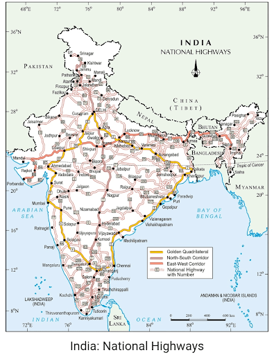
Image Credit: NCERT Textbook (Contemporary India)
Q2 On the map of India, mark the railways using appropriate symbols.
Ans
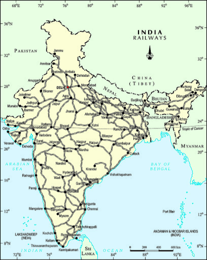
Image Credit: NCERT Textbook (Contemporary India)
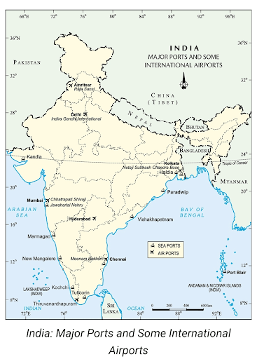
Q3 On the map of India, mark the major ports and international airports using appropriate symbols.
- Paradwip- Major Sea port (CBSE SAMPLE PAPER 2019-20)
- Vishakhapatnam Port (CBSE SAMPLE PAPER 2020-21)
- Kochi Port (CBSE SAMPLE PAPER 2022-23)
- Chattrapati Shivaji International Airport (CBSE SAMPLE PAPER 2019-20)
- Raja Sansi (Sri Guru Ram Dass Jee) International Airport (CBSE SAMPLE PAPER 2021-22)
Ans