NCERT Solutions for Class 10 Geography Chapter 1 Resources and Development – Important Questions
Given in this post is NCERT Solutions for Class 10 Geography Chapter 1 Resources and Development. The important questions we have compiled will help the students to brush up on their knowledge about the subject. Students can practice Class 10 Geography important questions to understand the subject better and improve their performance in the board exam. The NCERT solutions provided here will also give students an idea about how to write the answers.
- Resources and Development Multiple Choice Questions
- Resources and Development 1 Mark Questions
- Resources and Development Assertion-reason based questions
- Resources and Development Fill in the blanks
- Resources and Development 2 Mark Questions
- Resources and Development 3 Mark Questions
- Resources and Development 4 Mark Questions
- Resources and Development 5 Mark Questions
- Resources and Development Map Based Questions
MCQ Based Questions
Q1 Which one of the following types of resource is iron ore? (NCERT QUESTION)
A Renewable
B Biotic
C Flow
D Non-renewable
Ans D Non-renewable
Q2 Under which of the following types of resource can tidal energy be put? (NCERT QUESTION)
A Replenishable
B Human-made
C Abiotic
D Non-recyclable
Ans A Replenishable
Q3 Which one of the following is the main cause of land degradation in Punjab? (NCERT QUESTION)
A Intensive cultivation
B Deforestation
C Over irrigation
D Overgrazing
Ans C Over irrigation
Q4 In which one of the following states is terrace cultivation practised? (NCERT QUESTION)
A Punjab
B Plains of Uttar Pradesh
C Haryana
D Uttarakhand
Ans D Uttarakhand
Q5 In which of the following states is black soil found? (NCERT QUESTION)
A Jammu and Kashmir
B Gujarat
C Rajasthan
D Jharkhand
Ans B Gujarat
Q6 On the basis of origin, resources can be classified as __________ and __________.
A Biotic and Abiotic
B Renewable and Non-renewable
C Potential and Developed
D None of the above
Ans A Biotic and Abiotic
Q7 On the basis of the status of development, resources can be classified as __________.
A Potential
B Developed Stock
C Reserves
D All of the above
Ans D All of the above
Q8 Which of the following statements are true?
A Abiotic resources are obtained from the biosphere and have life, such as human beings, flora and fauna.
B Biotic resources are all those things which are composed of non-living things like rocks and metals.
C Both the above statements are false.
D Both the options A and B are true.
Ans C Both the above statements are false.
Q9 Minerals and fossil fuels are examples of non-renewable resources which take __________ for their formation.
A Hundreds of years
B Thousands of years
C Millions of years
D Just a year
Ans C Millions of years
Q10 All the minerals, water resources, forests, wildlife, land within the political boundaries and oceanic area up to __________ from the coast termed as territorial water and resources therein belong to the nation.
A 20 nautical miles
B 25 nautical miles
C 15 nautical miles
D 12 nautical miles
Ans D 12 nautical miles
Q11 The oceanic resources beyond ______________ of the Exclusive Economic Zone belong to open ocean, and no individual country can utilise these without the concurrence of international institutions.
A 200 nautical miles
B 12 nautical miles
C 22.5 nautical miles
D 100 nautical miles
Ans A 200 nautical miles
Q12 __________ are the resources which are surveyed, and their quality and quantity have been determined for utilisation.
A Developed resources
B Reserves
C Stock
D Abiotic
Ans A Developed resources
Q13 _________ are the subset of the _________, which can be put into use with the help of existing technical ‘know-how’, but their use has not been started.
A Reserves, Developed Resources
B Stocks, Reserves
C Developed Resources, Stock
D Reserves, Stock
Ans D Reserves, Stock
Q14 In June 1992, more than 100 heads of states met in __________ in Brazil, for the first International Earth Summit.
A Rio de Janeiro
B São Paulo
C Brasilia
D Curitiba
Ans A Rio de Janeiro
Q15 The Rio Convention endorsed the global Forest Principles and adopted __________ for achieving Sustainable Development in the 21st century.
A Agenda 20
B Agenda 21
C Agenda 19
D Agenda 22
Ans B Agenda 21
Q16 Which of the following statements about Agenda 21 is true?
A It aims at achieving global sustainable development.
B It is an agenda to combat environmental damage, poverty and disease through global cooperation.
C One of the major objectives of Agenda 21 is that every local government should not draw its own local Agenda 21.
D Option A and B.
Ans D Option A and B.
Q17 The states of Jharkhand, Chhattisgarh and Madhya Pradesh are rich in minerals and ___________ deposits.
A Coal
B Gold
C Silicon
D None of the above
Ans A Coal
Q18 The state of Rajasthan is very well endowed with solar and __________ energy but lacks in water resources.
A Geothermal
B Hydro
C Wind
D Tidal
Ans C Wind
Q19 ________ was the famous Indian freedom fighter who made an important observation about resource conservation – “There is enough for everybody’s need and not for anybody’s greed”.
A Mahatma Gandhi
B Jawaharlal Nehru
C Subash Chandra Bose
D Dr B.R.Ambedkar
Ans A Mahatma Gandhi
Q20 The Brundtland Commission Report published in ________, shared ideas about sustainable development and how it could be achieved.
A 1997
B 1987
C 1992
D 1977
Ans B 1987
Q21 About _________ of India’s land area is plain, which provides facilities for agriculture and industry.
A 43%
B 53%
C 34%
D 45%
Ans A 43%
Q22 ____________ accounts for 30% of the total surface area of India.
A Deserts
B Mountains
C Plains
D Plateaus
Ans B Mountains
Q23 Land which is left without cultivation for one or less than one agricultural year is known as ___________.
A Gross cropped area
B Culturable waste land
C Current fallow
D Grazing land
Ans C Current fallow
Q24 Land which is left uncultivated for more than 5 agricultural years is known as __________.
A Culturable waste land
B Barren land
C Pastures
D Fallow Lands
Ans A Culturable waste land
Q25 The pattern of the net sown area varies greatly from one state to another. It is over 80 per cent of the total area in __________.
A Madhya Pradesh
B Assam
C Rajasthan
D Punjab
Ans D Punjab
Q26 Which one of the following is an example of Cultivable Wasteland? (CBSE SAMPLE PAPER 2019-20)
A Gross cropped Area
B Uncultivable Land
C Barren Wasteland
D Current fallow Land
Ans B Uncultivable Land
Q27 Which one of the following conferences was convened to discuss environmental protection and socio-economic development at the global level in 1992? (CBSE SAMPLE PAPER 2021-22)
A Kyoto Protocol
B Montreal Protocol
C Rio de Janeiro Earth Summit
D World Summit on Sustainable Development
Ans C Rio de Janeiro Earth Summit
Q28 India has land under a variety of relief features. Which of the following features ensure perennial flow of some rivers, provide facilities for tourism and ecological aspects? (CBSE SAMPLE PAPER 2021-22)
A Plains
B Plateaus
C Islands
D Mountains
Ans D Mountains
Q29 Which one of the following human activities has contributed significantly in land degradation? (CBSE SAMPLE PAPER 2021-22)
A Deforestation
B Crop rotation
C Shelter belts
D Ploughing
Ans A Deforestation
Q30 Identify the soil with the help of clues given below – (CBSE SAMPLE PAPER 2021-22)
- develops in areas with high temperature and heavy rainfall
- is low in humus content
- found in the hilly areas of Karnataka, Kerala and Tamil Nadu
A Forest soil
B Yellow soil
C Black soil
D Laterite soil
Ans D Laterite soil
Q31 Which of the following categories of resources can we put Tidal energy in? (CBSE SAMPLE PAPER 2021-22)
A Renewable resources
B Non-renewable resources
C Actual resources
D Potential resources
Ans A Renewable Resources
Q32 Identify the crop with the help of the following information (CBSE SAMPLE PAPER 2022-23)
- It is a crop which is used both as food and fodder.
- It is a kharif crop which requires a temperature between 21°C to 27°C.
- It grows well in old alluvial soil.
- Use of modern inputs have contributed to the increasing production of this crop.
A Wheat
B Maize
C Rice
D Sugarcane
Ans B Maize
Q33 Match the following : (CBSE SAMPLE PAPER 2022-23)
| Resources | Examples |
| a. Renewable Resources | I. Forests and wildlife |
| b. Non -Renewable Resources | II. The oceanic resources |
| c. National Resources | III. Roads, canals and railway |
| d. International Resources | IV. Minerals and fossil fuels |
Options
A a-I, b-IV, c-III, d-II
B a-II, b-I, c-IV, d-III
C a-IV, b-I , c-IV, d-II
D a-I, b-IV, c-II, d-III
Ans A a-I, b-IV, c-III, d-II
Top
1 Mark Questions
Q1 What steps can be taken to control soil erosion in the hilly areas? (NCERT QUESTION)
Ans ‘Shelterbelt plantation’ and ‘Terrace farming’ can be done to prevent soil erosion in hilly areas.
Q2 Define the term ‘Resource’.
Ans Everything available in our environment, which can be used to satisfy our needs, provided, it is technologically accessible, economically feasible and culturally acceptable can be termed as ‘Resource’.
Q3 What is the role of human beings in the development of a resource?
Ans Human beings transform material available in our environment into resources and use them.
Q4 What are renewable resources?
Ans The resources which can be renewed or reproduced by physical, chemical or mechanical processes are known as renewable or replenishable resources. Example-water, forests, wildlife, etc.
Q5 What are non-renewable resources?
Ans These resources cannot be renewed or replenished. They take millions of years in their formation. Example-coal, mineral oil, iron ore, bauxite, etc.
Q6 Define Individual Resources.
Ans These resources are owned privately by individuals. Example- Plantation, pasture lands, ponds, water in wells, etc. are resources owned by individuals.
Q7 Which resources are community owned resources?
Ans These are resources which are accessible to all the members of the community. Example- Public parks, picnic spots, cinema halls, playgrounds, etc.
Q8 What are National Resources.
Ans Technically, all the resources available in a nation are categorised as National Resources. Example-Minerals, wild life, forests, water resources, land of a nation, roads, railways.
Q9 What are Potential Resources?
Ans Resources which are found in a region but have not been utilised. Example- Wind and solar energy can be generated in parts of Gujarat and Rajasthan (they are potential).
Q10 Define Developed Resources.
Ans Resources which are surveyed, their quality and quantity is determined and they are developed for use. Example-Coal, mineral oil.
Q11 What do you mean by sustainable development?
Ans Sustainable economic development means development should take place without damaging the environment and development in the present should not compromise with the needs of the future generation.
Q12 When and where was the first International Earth Summit held?
Ans The first International Earth Summit, held at Rio de Janeiro in Brazil in June 1992, where 100 heads of states met.
Q13 What was Agenda 21 of Earth Summit of Rio de Janeiro?
Ans The agenda was to combat environmental damage, poverty, disease through global cooperation on common interests, mutual needs and shared responsibilities.
Q14 Why is resource conservation important?
Ans Irrational consumption and over-utilisation of resources may lead to socio-economic and environmental problems. To overcome these problems, resource conservation at various levels is important.
Q15 What is the importance of land as a natural resource?
Ans Land supports natural vegetation, wild life, human life, economic activities, transport and communication systems. Thus, land is a natural resource of utmost importance.
Q16 What is Net Sown Area?
Ans It is the actual area under cultivation. This area is cultivated once or twice in about two to three years.
Q17 What is the gross cropped area?
Ans It is the actual area under cultivation along with the fallow land, which is left uncultivated for fertility.
Q18 What is waste land?
Ans Waste land includes rocky, arid and desert areas and land put to other non agricultural uses including settlements, roads, railways, industries, etc.
Q19 How does land degradation occur?
Ans Continuous use of land over a long period of time without taking appropriate measures to conserve and manage it, results in land degradation.
Q20 What is the percentage of land degradation in India?
Ans In India, 28% of forest belongs to degraded area, 56% is water eroded area, 10% is wind eroded area and the rest is affected by saline and alkaline deposits.
Q21 In which states is land degraded due to mining?
Ans In states like Jharkhand, Chattisgarh, Madhya Pradesh and Odisha, deforestation due to mining has caused severe land degradation.
Q22 In which states is over irrigation responsible for land degradation?
Ans In the states of Punjab, Haryana and Western Uttar Pradesh, over irrigation is responsible for land degradation due to water-logging leading to increase in salinity and alkalinity in the soil.
Q23 How is mineral processing responsible for land degradation?
Ans The mineral processing like grinding of limestone for cement industry and calcite and soapstone for ceramic industry generate huge quantities of dust in the atmosphere. It retards the process of infiltration of water into the soil after it settles down on the land.
Q24 Why is soil considered as an important resource?
Ans Soil is the most important renewable natural resource. It is the medium of plant growth and supports different types of living organisms on the earth.
Q25 Which factors help in the formation of soil?
Ans Relief, parent rock or bedrock, climate, vegetation and other forms of life and time are important factors in the formation of soil.
Q26 Which forces of nature help in the formation of soil?
Ans Various forces of nature such as change in temperature, actions of running water, wind and glaciers, activities of decomposition, etc. contribute to the formation of soil.
Q27 Which soils are formed at the foothills?
Ans In the upper reaches of the river valley i.e., near the place of the break of slope, the soils are coarse. Such soils are more common in piedmont plains such as Duars, Chos and Terai.
Q28 What is ‘Bangar”?
Ans Bangar is an old alluvial soil. It has a high concentration of kanker nodules in it.
Q29 What is ‘khadar’?
Ans Khadar is a new alluvial soil. It has more fine particles and is more fertile than the bangar.
Q30 Why is alluvial soil called ‘fertile soil’?
Ans Mostly alluvial soil contains an adequate proportion of potash, phosphoric acid and lime which are ideal for the growth of sugarcane, paddy, wheat and other cereal and pulse crops.
Q31 Which soils are called ‘black soils’?
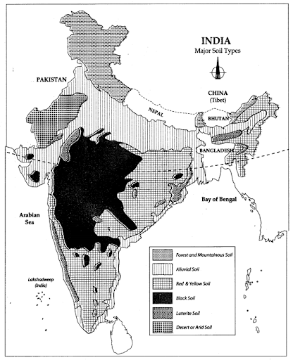
Ans Soils which are black in colour are called black soils or Regur soils. Since they are ideal for growing cotton, they are also known as black cotton soils.
Q32 In which regions are black soils found?
Ans Black soils cover the plateaus of Maharashtra, Saurashtra, Malwa, Madhya Pradesh and Chhattisgarh.
Q33 What are the chief characteristics of black soil?
Ans Black soils are made up of extremely fine, l.e., clayey material. They are well known for their capacity to hold moisture.
Q34 What is the main drawback of black soil?
Ans This soil is sticky when wet and difficult to work on unless tilled immediately after the first shower or during the pre-monsoon period. This soil is also poor in phosphoric contents.
Q35 How are red soils formed?
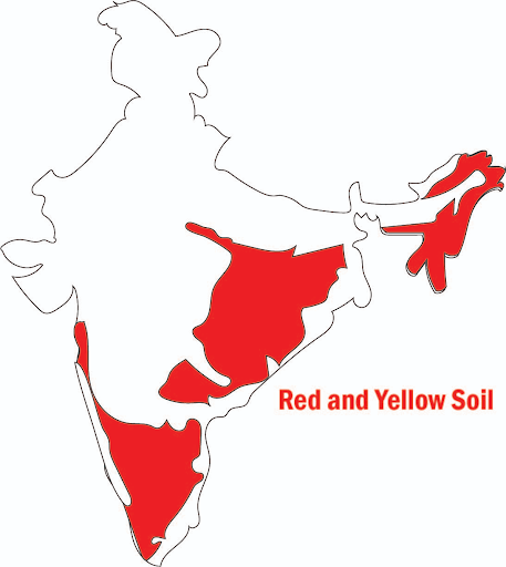
Ans Red soils develop on crystalline igneous rocks in areas of low rainfall in the eastern and southern parts of the Deccan plateau.
Q36 How do the red soils look red or yellow in colour?
Ans These soils develop a reddish colour due to diffusion of iron in crystalline and metamorphic rocks. It looks yellow when it occurs in a hydrated form.
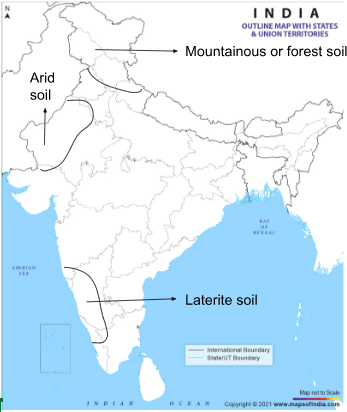
Q37 How are laterite soils formed?
Ans The laterite soils are developed in areas with high temperature and heavy rainfall. This is the result of intense leaching due to heavy rain.
Q38 Why is humus content in laterite soil low?
Ans Humus content of the soil is low because most of the microorganisms, particularly the decomposers, like bacteria get destroyed due to high temperature.
Q39 In which regions are laterite soils formed?
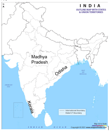
Ans These soils are mainly found in Karnataka, Kerala, Tamil Nadu, Madhya Pradesh and the hilly areas of Odisha and Assam.
Q40 What are the drawbacks of arid soils?
Ans Due to dry climate, high temperature, evaporation is faster and the soil lacks humus and moisture. The kanker layer formations in the bottom horizons restrict the infiltration of water.
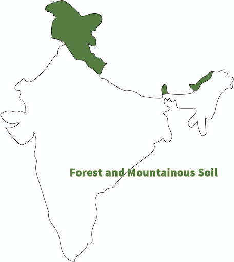
Q41 Give one characteristic of forest soils.
Ans In the snow covered areas of Himalayas, these soils experience denudation and are acidic with low humus content.
Q42 What is soil erosion?
Ans The denudation of the soil cover and subsequent washing down is described as soil erosion.
Q43 How is soil eroded?
Ans Soil is eroded due to human activities like deforestation, overgrazing and construction and mining. etc. Natural forces like wind, glacier and water also lead to soil erosion.
Q44 What are gullies?
Ans The running water cuts through the clayey soils and makes deep channels as gullies. The land becomes unfit for cultivation and is known as bad land.
Q45 What is sheet erosion?
Ans Sometimes water flows as a sheet over large areas down a slope. In such cases the top soil is wasted away. This is known as sheet erosion.
Q46 How does soil erosion take place due to defective methods of farming?
Ans Ploughing in a wrong way, i.e., up and down the slope form channels for the quick flow of water leading to soil erosion.
Q47 What is contour ploughing?
Ans Ploughing along the contour lines can decelerate the flow of water down the slopes. This is called contour ploughing.
Q48 How does Terrace farming help in checking soil erosion?
Ans Steps can be cut out on the slopes making terraces. Terrace cultivation restricts erosion.
Q49 What is strip cropping?
Ans Large fields can be divided into strips. Strips of grass are left to grow between the crops. This breaks up the force of the wind. This method is known as strip cropping.
Q50 Why are shelter belts grown?
Ans Planting lines of trees to create shelter also work in a similar way. Rows of such trees are called shelter belts. These shelter belts have contributed significantly to the stabilisation of sand dunes and in stabilising the desert in western India.
Q51 “Conservation of resources is vital for development.” Give one example regarding the statement. (CBSE SAMPLE PAPER 2018-19)
Ans Example of conservation of resources is afforestation and water treatment.
Q52 “Degradation of land is a cause of worry.” Give one reason to support the statement. (CBSE SAMPLE PAPER 2018-19)
Ans Degradation of land is a cause of worry because it can cause ecological imbalance.
Q53 Identify the soil with the help of the following features: (CBSE SAMPLE PAPER 2019-20)
- Red to brown in colour
- Sandy in texture and saline in nature
- Lacks humus and moisture
Ans Arid soil
Top
Assertion-reason based questions:
Q1 Assertion (A): Land is a resource of utmost importance.
Reason (R): Land can be used for various purposes like agriculture and industry.
Options:
- Both A and R are true and R is the correct explanation of A.
- Both A and R are true but R is not the correct explanation of A.
- A is true but R is false.
- A is false but R is true.
Ans a. Both A and R are true and R is the correct explanation of A.
Q2 Assertion (A): The black soils are made up of extremely fine clayey material.
Reason (R): They are well known for their capacity to hold moisture.
Options:
- Both A and R are true and R is the correct explanation of A.
- Both A and R are true but R is not the correct explanation of A.
- A is true but R is false.
- A is false but R is true.
Ans b. Both A and R are true but R is not the correct explanation of A.
Q3 Assertion (A): Alluvial soils are very fertile.
Reason (R): Mostly these soils contain an adequate proportion of potash, phosphoric acid, and lime.
Options:
- Both A and R are true and R is the correct explanation of A.
- Both A and R are true but R is not the correct explanation of A.
- A is true but R is false.
- A is false but R is true.
Ans a. Both A and R are true and R is the correct explanation of A.
Q4 Assertion (A): Rajasthan and Gujarat have enormous potential for the development of wind and solar energy, but so far these have not been developed properly.
Reason (R): Materials in the environment which have the potential to satisfy human needs but human beings do not have the appropriate technology to access these, are included among developed resources.
Options:
- Both A and R are true and R is the correct explanation of A.
- Both A and R are true but R is not the correct explanation of A.
- A is true but R is false.
- A is false but R is true.
Ans c. A is true but R is false.
Q5 Assertion (A): Biotic Resources are obtained from the biosphere and have life such as human beings, flora and fauna.
Reason (R): Abiotic Resources are those things which are composed of nonliving things ,for example, rocks, air and metals.
Options:
- Both A and R are true and R is the correct explanation of A.
- Both A and R are true but R is not the correct explanation of A.
- A is true but R is false.
- A is false but R is true.
Ans b. Both A and R are true but R is not the correct explanation of A.
Q6 Assertion (A): Agenda 21 was signed in 1992 in Rio de Janeiro.
Reason (R): Sustainable development focused on utilization of resources.
Options:
- Both A and R are true and R is the correct explanation of A.
- Both A and R are true but R is not the correct explanation of A.
- A is true but R is false.
- A is false but R is true.
Ans b. Both A and R are true but R is not the correct explanation of A.
Q7 Assertion (A): Public parks, picnic spots, playgrounds in urban areas are community owned resources.
Reason (R): They are accessible to all the people living there.
Options:
- Both A and R are true and R is the correct explanation of A.
- Both A and R are true but R is not the correct explanation of A.
- A is true but R is false.
- A is false but R is true.
Ans a. Both A and R are true and R is the correct explanation of A.
Q8 Assertion (A): Ploughing along the contour lines decelerates the flow of water down the slopes and controls soil erosion.
Reason (R): Soil erosion is the washing away of top layer of soil or denudation of soil cover.
Options:
- Both A and R are true and R is the correct explanation of A.
- Both A and R are true but R is not the correct explanation of A.
- A is true but R is false.
- A is false but R is true.
Ans b. Both A and R are true but R is not the correct explanation of A.
Q9 Assertion (A): All the resources belong to the nation.
Reason (R): International institutions regulate the oceanic resources beyond 200 nautical miles of the Exclusive Economic Zone.
Options:
- Both A and R are true and R is the correct explanation of A.
- Both A and R are true but R is not the correct explanation of A.
- A is true but R is false.
- A is false but R is true.
Ans b. Both A and R are true but R is not the correct explanation of A.
Q10 Assertion (A): Resources are not vital for any developmental activity.
Reason (R): Excessive consumption and over utilisation of resources may lead to socio-economic and environmental problems.
Options:
- Both A and R are true and R is the correct explanation of A.
- Both A and R are true but R is not the correct explanation of A.
- A is true but R is false.
- A is false but R is true.
Ans d. A is false but R is true.
Top
Fill in the blanks in the following:
Q1 ______________ transform material available in our environment into resources and use them.
Ans Human beings
Q2 ________________ are resources which are accessible to all the members of the community.
Ans Community owned resources
Q3 ________________ means development should take place without damaging the environment and development in the present should not compromise with the needs of the future generation.
Ans Sustainable development
Q4 The first International Earth Summit, held at _____________ in Brazil in June 1992, where 100 heads of states met.
Ans Rio de Janeiro
Q5 In states like _______________, deforestation due to mining has caused severe land degradation.
Ans Jharkhand, Chattisgarh, Madhya Pradesh and Odisha
Q6 Relief, parent rock or bedrock, climate, vegetation and other forms of life and time are important factors in the ___________________.
Ans formation of soil
Q7 ___________ is an old alluvial soil. It has a high concentration of kanker nodules in it.
Ans Bangar
Q8 The _____________ are developed in areas with high temperature and heavy rainfall. This is the result of intense leaching due to heavy rain.
Ans laterite soils
Q9 _________ content of the soil is low because most of the microorganisms, particularly the decomposers, like bacteria get destroyed due to high temperature.
Ans Humus
Q10 The denudation of the soil cover and subsequent washing down is described as _____________.
Ans soil erosion
Top
2 Mark Questions
Q1 Name three states having black soil and the crop which is mainly grown in it. (NCERT QUESTION)
Ans. The three states are Maharashtra, Madhya Pradesh, Gujarat.
The crop which is mainly grown on black soil is cotton.
Q2 What type of soil is found in the river deltas of the eastern coast? Give three main features of this type of soil. (NCERT QUESTION)
Ans. Alluvial soil is formed in the river deltas of the eastern coast.
Its main features are:
- Alluvial soil is rich in potassium and phosphoric acid and lime.
- It has a high water retention capacity.
- It is highly fertile soil.
Q3 What are the biotic and abiotic resources? Give some examples. (NCERT QUESTION)
Ans. Biotic resources: Resources obtained from living organisms in our environment are called biotic resources. Example – trees, animals, insects, etc.
Abiotic resources: Things composed of non-living things present in our environment are termed as abiotic resources. Example: earth, water, metals, etc.
Q4 Which resources are termed as ‘International Resources’?
Ans. There are international institutions which regulate some resources. These resources can be utilised by any country of the world. Example- The oceanic resources beyond 200 nautical miles of the Exclusive Economic Zone belong to open ocean and no individual country can utilise without the unanimity of international institutions.
Q5 What do you understand by the term ‘stock’? Give examples.
Ans. Stock is the materials in the environment, which have the potential to satisfy human needs but human beings do not have the appropriate technology to access these. Example: Water can be made with two gases-hydrogen and oxygen, but we do not have required technology to use it.
Q6 What are ‘Reserves’?
Ans 1. Reserves are the subset of the stock, which can be put into use with the help of existing technical know how but their use has not been started.
- These can be used for meeting future requirements. Example-water in the dams, forests, etc is a reserve which can be used in the future.
Q7 Why is there a need for planning resources in India?
Ans 1. We need to have resource planning in India since India has enormous diversity in the availability of resources.
- There are regions which are rich in certain types of resources but are deficient in some other resources. This calls for balanced resource planning at national, state and regional levels.
Q8 What are the three processes involved in Resource Planning?
Ans 1. Identification and inventory of resources across the regions of the country.
- Evolving a planning structure with appropriate technology.
- Matching the resource development plans with overall national development plans.
Q9 How are resources associated with colonialism?
Ans 1. The history of colonisation reveals that rich resources in colonies were the main attractions for the foreign invaders.
- It was primarily the higher level of technological development of the imperial powers that helped them exploit the resources of the colonies.
Q10 What are the main relief features of India?
Ans India has land under a variety of relief features:
- Plains cover 43% of the land area.
- Mountains account for 30% area and
- Plateau regions cover about 27% of the area.
Q11 Which factors determine the use of land?
Ans 1. Physical factors-topography, climate, soil types.
- Human factors-Population density, technological capability and culture and tradition, etc.
Q12 What is soil erosion? State how it can be prevented in deserts.
Ans 1. Soil erosion is denudation of the soil cover and subsequent washing down.
- Planting lines of trees to create shelter prevents soil erosion. Rows of such trees are called shelter belts. These shelter belts have contributed significantly to the stabilisation of sand dunes and in stabilising the desert in western India.
Q13 Why do we need to conserve resources?
Ans 1. Resources are vital for any developmental activity. But irrational consumption and overutilisation of resources may lead to socio-economic and environmental problems.
- To overcome these problems, resource conservation at various levels is important.
Q14 How laterite soils are formed? Give any one negative and one positive aspect of the soil.
Ans The laterite soils develop in areas with high temperature and heavy rainfall. This is the result of intense leaching due to heavy rains.
- Positive Aspect: After adopting appropriate soil conservation techniques particularly in the hilly areas of Karnataka, Kerala and Tamil Nadu, this soil is very useful for growing tea and coffee.
- Negative Aspect: Humus content of the soil is low because most of the micro-organisms, particularly the decomposers like bacteria, get destroyed due to high temperature.
Q15 How are red and yellow soils formed? Why do they look red?
Ans 1. Red soils develop on crystalline igneous rocks in areas of low rainfall in the eastern and southern parts of the Deccan Plateau.
- These soils develop a reddish colour due to diffusion of iron in crystalline and metamorphic rocks. It looks yellow when it occurs in a hydrated form.
3 Mark Questions
Q1 Explain land use pattern in India and why has the land under forest not increased much since 1960-61? (NCERT QUESTION)
Ans 1. About 45 per cent of land is used as net sown areas, i.e., farming.
- About 22 per cent of land is under forest and the rest of the land is used for various purposes; such as housing, recreation and industrial activities.
- The main reason that forest land has not increased since 1960-61 is that there is an increase in population and subsequent increase in demand for resources.
Q2 How have technical and economic development led to more consumption of resources? (NCERT QUESTION)
Ans Technical and economic development involves more utilisation and exploitation of resources for the purpose of present development. As the history of our colonisation shows, it was mainly one of the higher levels of technological development of the colonising countries that helped them to exploit resources of the regions and establish their own power over the colonies.
- Technological development has led to more industries and therefore use of natural resources has increased.
- As means of transportation and communication are developing fast, they help in the mobility of the resources.
- Due to technological advancement, techniques of mining and quarrying are also improving, leading to safer mining and more resources and more economic development.
- The Green Revolution led to the introduction of the latest mechanical devices, fertilisers, HYV seeds, etc., leading to more and more production and consumption of resources.
Q3 Describe the process of resource planning in India.
Ans Resource planning is a complex process. It involves the following process:
- Identification and inventory of resources across the regions of the country: It involves surveying, mapping, qualitative and quantitative estimation and measurement of the resources.
- Evolving a planning structure: In it, we make appropriate use of technology, skill and institutional set up for implementing resource development plans.
- Matching the resource development plans: It matches the development of resources with overall national development plans.
Q4 What is the importance of land?
Ans We live on land, we perform our economic activities on land and we use it in different ways:
- Land is a natural resource and of utmost importance.
- It supports natural vegetation, wildlife, human life, economic activities, and transport and communication systems.
- It is an asset of a finite magnitude. It is important to use the available land for different purposes with careful planning.
Q5 For what purposes are land resources used?
Ans Land resources are used for the following purposes:
- Forests
- Land not available for cultivation: Barren and waste land; land used for buildings, roads, etc.
- Other uncultivated land: Permanent pastures and grazing lands.
- Fallow land: Left fallow for regaining the fertility of the soil.
- Net sown area: Where actual cultivation takes place.
Q6 What is the importance of soil as a resource?
Ans 1. Soil is the most important renewable natural resource.
- It is the medium of plant growth and supports different types of living organisms on the Earth.
- Soil helps in providing food to this Earth.
Q7 Distinguish between Khadar and Bangar.
Ans
| S. No. | Khadar | Bangar |
| 1. | It is new alluvial soil. | It is an old alluvial soil. |
| 2. | It is more fertile. | It is less fertile. |
| 3. | It is found near the banks of rivers. | It is found farther away from the river. |
| 4. | It has fine particles. | It has kanker nodules in it. |
Q8 Give some important features of the black soil.
Ans 1. Black soils are made up of extremely fine; clayey material.
- They are well-known for their capacity to hold moisture.
- They are rich in soil nutrients such as calcium carbonate, magnesium, potash and lime.
- They develop deep cracks during hot weather, which helps in the proper aeration of the soll.
Q9 Name the states in which laterite soils are found and give any two characteristics of this soil.
Ans Laterite soils are found in Karnataka, Kerala, Tamil Nadu, Madhya Pradesh and in the hilly areas of Odisha and Assam.
Chief characteristics:
- Humus content of the soil is low because most of the microorganisms, particularly the decomposers like bacteria, get destroyed due to high temperature.
- Laterite soils are suitable for cultivation with adequate doses of manures and fertilisers.
Q10 Explain the interdependent relationship between nature, technology and institutions. Also make a diagram to represent the same.
Ans 1. Human beings interact with nature.
- They use technology to transform material available in the environment into resources.
- They create institutions to accelerate their resource development.
Q11 Why was the Rio de Janeiro Earth Summit, 1992 held?
Ans 1. In June 1992, more than 100 heads of states met in Rio de Janeiro, Brazil for the first International Earth Summit.
- It was held to address urgent problems of environmental protection and socio-economic development at the global level.
- This convention adopted Agenda 21, for achieving sustainable development in the 21st century.
Q12 What were the aims of Agenda 21 to achieve global sustainable development?
Ans 1. It aimed at achieving global sustainable development.
- The agenda was to combat environmental damage, poverty and diseases.
- It can be achieved through global cooperation on common interests, mutual needs and shared responsibilities.
Q13 Why are arid soils found to be non-productive?
Ans 1. These soils are generally sandy in texture and saline in nature.
- In some areas, the salt content is very high and common salt is obtained by evaporating the water.
- Due to the dry climate, high temperature, evaporation is faster and the soil lacks humus and moisture. The lower horizons of the soil are occupied by kanker, which restricts the infiltration of water.
Q14 Which factors affect the land use pattern of India?
Ans 1. The land use pattern is determined by certain physical factors of the country such as topography, climate and soil types. The availability of geographical area determines its uses by the country. In India, we have various forms of land like plains, plateaus, mountains, etc. which are kept in mind before planning the land use pattern.
- There are certain human factors also affecting the land use pattern. They include population density of the country, technological capability, culture and traditions of the country, etc. The economic development of the country depends on the technological development of the country thus leading to the planning of land use patterns.
Q15 Define the term ‘Resource’. Do you think that resources are free gifts of nature? Support your argument.
Ans 1. Everything available in our environment which can be used to satisfy our needs, provided it is technologically accessible and economically feasible and culturally acceptable can be termed as ‘Resource’.
- Resources are not free gifts of nature. These are a function of human activities.
- Human beings themselves are essential components of resources. They transform material available in our environment into resources and use them.
Q16 What is land degradation? What do you know about India’s degraded land?
Ans Continuous use of land over a long period of time without taking appropriate measures to conserve and manage it, has resulted in land degradation.
India’s degraded land:
At present there is about 130 million hectares of degraded land in India. Approximately, 28 per deforestation, cent of it belongs to the category of forest degraded area. 56 percent of it is water eroded. The rest is affected by saline and alkaline deposits. Some human activities such as overgrazing, mining and quarrying too have contributed significantly to land degradation.
Q17 By what name is black soil also known as? In which regions are black soils formed and why?
Ans 1. These soils are black in colour and are also known as regur soils. Since black soil is ideal for growing cotton, it is also known as black cotton soil.
- It is believed that climatic conditions along with the parent rock material are the important factors for the formation of black soil.
- The type of soil is typical of the Deccan Trap (Basalt) region spread over northwest Deccan plateau and is made up of lava flows. They cover the plateaus of Maharashtra, Saurashtra, Malwa, Madhya Pradesh, Chhattisgarh and extend in the South east direction along the Godavari and the Krishna Valleys.
Q18 Explain the classification of resources on the basis of exhaustibility with the help of examples.
Ans
| Renewable resources | Non-renewable resources |
| 1. They can be renewed or reproduced. | 1. They occur over a very long geological period of time. |
| 2. They can be used over the years again and again. | 2. They get exhausted once used and cannot be used again. |
| 3. They are abundantly available. | 3. They are available in limited quantity. |
| 4. Eg: Solar and wind, energy, water, forests and wildlife, etc. | 4. Eg: Fossil fuels, and other minerals. |
Q19 Examine the three major problems created as a result of indiscriminate utilization of natural resources.
Ans Resources are vital for human survival as well as for maintaining the quality of life. Its indiscriminate use has led to the following problems:
- Depletion of resources for satisfying the greed of few individuals.
- Accumulation of resources in few hands, which in turn divided the society into two segments, i.e., haves and have-nots or rich and poor.
- Indiscriminate exploitation of resources has led to global ecological crisis such as global warming, ozone layer depletion, environmental pollution and land degradation.
Q20 “The Earth has enough resources to meet the need of all but not enough to satisfy the greed of even one person.” How is this statement relevant to the discussion of development? Discuss.
Ans Gandhiji was very apt in voicing his concern about resource conservation.
- He said there is enough for everybody’s need and not for anybody’s greed.
- He regarded the greedy and selfish individuals and the exploitative nature of technology as the root cause for resource depletion at the global level.
- He was against mass production and wanted to replace it with the production by the masses.
Q21 Why is soil considered as a living system? Mention any two factors that are responsible for soil formation.
Ans 1. The soil is a living system, it takes millions of years to form soil upto a few cms in depth.
2. Relief parent rock, climate, vegetation and other forms of life and time are important factors in the formation of soil.
- Various forces of nature such as change in temperature, actions of running water, wind and glaciers, activities of decomposers, etc. contribute to the formation of soil. Chemical and organic changes which take place in the soil are equally important.
Q22 Do you think that resources are free gifts of nature as is assumed by many? Explain your argument.
Ans Resources are not free gifts of nature as:
- Resources are a function of human activities.
- Human beings themselves are essential components of resources.
- They transform material available in our environment into resources and use them.
4 Mark Questions
Q1 Read the extract and answer the questions that follows:
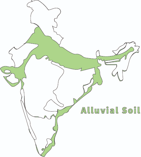
India has varied relief features, landforms, climatic realms and vegetation types. These have contributed to the development of various types of soils. Alluvial Soils are the most widely spread and important soil. In fact, the entire northern plains are made of alluvial soil. These have been deposited by three important Himalayan river systems-the Indus, the Ganga and the Brahmaputra. These soils also extend in Rajasthan and Gujarat through a narrow corridor. Alluvial soil is also found in the eastern coastal plains particularly in the deltas of the Mahanadi, the Godavari, the Krishna and the Kaveri rivers. The alluvial soil consists of various proportions of sand, silt and clay. As we move inlands towards the river valleys, soil particles appear somewhat bigger in size. In the upper reaches of the river valley i.e. near the place of the break of slope, the soils are coarse. Such soils are more common in piedmont plains such as Duars, Chos and Terai. Apart from the size of their grains or components, soils are also described on the basis of their age. According to their age alluvial soils can be classified as old alluvial (Bangar) and new alluvial (Khadar). The bangar soil has higher concentration of kanker nodules than the Khadar. It has more fine particles and is more fertile than the bangar. Alluvial soils as a whole are very fertile. Mostly these soils contain an adequate proportion of potash, phosphoric acid and lime which are ideal for the growth of sugarcane, paddy, wheat and other cereal and pulse crops. Due to its high fertility, regions of alluvial soils are intensively cultivated and densely populated. Soils in the drier areas are more alkaline and can be productive after proper treatment and irrigation.
- Which soils are formed at the foothills?
Ans In the upper reaches of the river valley i.e., near the place of the break of slope, the soils are coarse. Such soils are more common in piedmont plains such as Duars, Chos and Terai.
- ___________ is an old alluvial soil. It has a high concentration of kanker nodules in it.
Ans Bangar
- What is ‘khadar’?
Ans Khadar is a new alluvial soil. It has more fine particles and is more fertile than the bangar.
- Why is alluvial soil called ‘fertile soil’?
Ans Mostly alluvial soil contains an adequate proportion of potash, phosphoric acid and lime which are ideal for the growth of sugarcane, paddy, wheat and other cereal and pulse crops.
Q2 Read the extract and answer the questions that follows:
Sustainable economic development means ‘development should take place without damaging the environment, and development in the present should not compromise with the needs of the future generations. In June 1992, more than 100 heads of states met in Rio de Janeiro in Brazil, for the first International Earth Summit. The Summit was convened for addressing urgent problems of environmental protection and socio economic development at the global level. The assembled leaders signed the Declaration on Global Climatic Change and Biological Diversity. The Rio Convention endorsed the global Forest Principles and adopted Agenda 21 for achieving Sustainable Development in the 21st century. Agenda 21 is the declaration signed by world leaders in 1992 at the United Nations Conference on Environment and Development (UNCED), which took place at Rio de Janeiro, Brazil. It aims at achieving global sustainable development. It is an agenda to combat environmental damage, poverty, disease through global co-operation on common interests, mutual needs and shared responsibilities One major objective of the Agenda 21 is that every local government should draw its own local Agenda 21
- The first International Earth Summit, held at _____________ in Brazil in June 1992, where 100 heads of states met.
Ans Rio de Janeiro
- Assertion (A): Agenda 21 was signed in 1992 in Rio de Janeiro.
Reason (R): Sustainable development focused on utilization of resources.
Options:
- Both A and R are true and R is the correct explanation of A.
- Both A and R are true but R is not the correct explanation of A.
- A is true but R is false.
- A is false but R is true.
Ans b. Both A and R are true but R is not the correct explanation of A.
- The Rio Convention endorsed the global Forest Principles and adopted __________ for achieving Sustainable Development in the 21st century.
A Agenda 20
B Agenda 21
C Agenda 19
D Agenda 22
Ans B Agenda 21
- Which of the following statements about Agenda 21 is true?
A It aims at achieving global sustainable development.
B It is an agenda to combat environmental damage, poverty and disease through global cooperation.
C One of the major objectives of Agenda 21 is that every local government should not draw its own local Agenda 21.
D Option A and B.
Ans D Option A and B.
Q3 Read the extract and answer the questions that follows:
On the basis of the status of development, Potential Resources: Resources which are found in a region, but have not been utilised. For example, the western parts of India particularly Rajasthan and Gujarat have enormous potential for the development of wind and solar energy, but so far these have not been developed properly. Developed Resources: Resources which are surveyed and their quality and quantity have been determined for utilisation. The development of resources depends on technology and level of their feasibility. Identify at least two resources from each category. Do you know that India has got the right to mine manganese nodules from the bed of the Indian Ocean from that area which lies beyond the exclusive economic zone. Identify some other resources which are international in nature. Stock: Materials in the environment which have the potential to satisfy human needs but human beings do not have the appropriate technology to access these, are included among stock. For example, water is a compound of two gases, hydrogen and oxygen. Hydrogen can be used as a rich source of energy. But we do not have advanced technical know-how to use it for this purpose. Hence, it can be considered as stock. Reserves are the subset of the stock, which can be put into use with the help of existing technical know-how but their use has not been started. These can be used for meeting future requirements. River water can be used for generating hydroelectric power but presently, it is being utilised only to a limited extent. Thus, the water in the dams, forests etc. is a reserve which can be used in the future.
- Which of the following statements is true about the term resources?
A Resources are free gifts of nature.
B They are the functions of human activities.
C All the things which are found in nature.
D Things which cannot be used to fulfill our needs.
Ans B They are the functions of human activities.
- Identify the correct basis of the status of development potential resources.
| Basis | Potential resources |
|
1. No appropriate technology to use them. |
|
2. Not utilised |
|
3. Subset of stocks |
|
4. Surveyed (quantity and quality) |
Choose the correct option:
A a-1 ,b-3 ,c-2 ,d-4
B a-2 ,b-1 ,c-4 ,d-3
C a-3 ,b-1 ,c-4 ,d-2
D a-4 ,b-2 ,c-3 ,d-1
Ans B a-2 ,b-1 ,c-4 ,d-3
- Resources which are surveyed and their quality and quantity have been determined for utilisation are ____________.
A Potential Resources
B Individual Resources
C Developed Resources
D Stock
Ans C Developed Resources
- Resources that take long geological time for their formation are called:
A Renewable resources
B Reserve
C Community resources
D Non-renewable resources
Ans D Non-renewable resources
Q4 Read the extract and answer the questions that follows:
We have shared our land with the past generations and will have to do so with the future generations too. Ninety-five per cent of our basic needs for food, shelter and clothing are obtained from land. Human activities have not only brought about degradation of land but have also aggravated the pace of natural forces to cause damage to land. Some human activities such as deforestation, over grazing, mining and quarrying too have contributed significantly in land degradation. Mining sites are abandoned after excavation work is complete leaving deep scars and traces of over-burdening. In states like Jharkhand, Chhattisgarh, Madhya Pradesh and Odisha deforestation due to mining have caused severe land degradation. In states like Gujarat, Rajasthan, Madhya Pradesh and Maharashtra overgrazing is one of the main reasons for land degradation. In the states of Punjab, Haryana, western Uttar Pradesh, over irrigation is responsible for land degradation due to water logging leading to increase in salinity and alkalinity in the soil. The mineral processing like grinding of limestone for cement industry and calcite and soapstone for ceramic industry generate huge quantity of dust in the atmosphere. It retards the process of infiltration of water into the soil after it settles down on the land. In recent years, industrial effluents as waste have become a major source of land and water pollution in many parts of the country. There are many ways to solve the problems of land degradation. Afforestation and proper management of grazing can help to some extent. Planting of shelter belts of plants, control on over grazing, stabilisation of sand dunes by growing thorny bushes are some of the methods to check land degradation in arid areas. Proper management of waste lands, control of mining activities, proper discharge and disposal of industrial effluents and wastes after treatment can reduce land and water degradation in industrial and suburban areas.
- In which of the following States mining has caused severe land degradation?
A Gujarat
B Jharkhand
C Kerala
D Uttarakhand
Ans B Jharkhand
- In which of the following states is overgrazing responsible for land degradation?
A Jharkhand and Orissa
B Madhya Pradesh and Rajasthan
C Punjab and Haryana
D Kerala and Tamil Nadu
Ans B Madhya Pradesh and Rajasthan
- Which one of the following is the main cause of land degradation in Punjab?
A Intensive cultivation
B Deforestation
C Over-irrigation
D Overgrazing
Ans C Over-irrigation
- One of the following which does not check land degradation
A control on overgrazing
B creating shelter belts
C deforestation
D afforestation
Ans C deforestation
Top
5 Mark Questions
Q1 What efforts were made for resource planning in the First Five Year Plan?
Ans 1. The availability of resources is a necessary condition for the development of any region.
- But technological knowledge is an important prerequisite for it.
- There are many regions in our country that are rich in resources but are economically backward; whereas there are some regions which have a poor resource base but are economically developed.
- Resources can contribute to development only when they are accompanied by appropriate technological development.
- In India, development or resource development does not only mean the availability of resources but also the technology, quality of human resources and the historical experiences of the people.
Q2 What are the causes of land degradation?
Ans Causes of land degradation:
- Mining sites are abandoned after the excavation work is done, leaving deep scars of overburdening. In states like Odisha, Jharkhand, Madhya Pradesh, Chhattisgarh, deforestation due to mining has caused severe land degradation.
- Overgrazing in states like Gujarat, Rajasthan, Madhya Pradesh, and Maharashtra is one of the main reasons behind land degradation.
- Overirrigation and waterlogging lead to increase in salinity and alkalinity in the states of Punjab, Haryana and western Uttar Pradesh, thereby leading to land degradation.
- Mineral processing like grinding of limestone for cement industry and calcite and soapstone for ceremic industry generate huge quantities of dust in the atmosphere. It stops the infiltration of water in the soil.
- Industrial effluents as wastes have become a major source of land and water pollution in many parts of the country.
Q3 What is soil erosion? What are the main causes of soil erosion?
Ans Denudation of the soil cover and subsequent washing down is known as soil erosion.
Causes of soil erosion:
- Due to human activities like deforestation, overgrazing, construction and mining, etc.
- Natural forces like wind, glaciers and water lead to soil erosion.
- The running water cuts through clayey soils and makes deep channels as ‘gullies’. The land becomes unfit for cultivation, this process is called gully erosion and the land is called land or ravines in the Chambal basin.
- Sometimes, water flows as a sheet over large areas down a slope. It leads to the washing away of the topsoil. This process is called sheet erosion.
- Wind blows loose soil off flat or sloping land, and is called wind erosion.
- Soil erosion is also caused due to defective methods of farming.
Q4 What are the ways to solve land degradation?
OR
Suggest and explain any three ways to protect land from degradation in various states of India. (CBSE SAMPLE PAPER 2020-21)
Ans Ways to check land degradation:
- Afforestation and proper management of grazing can help to check land degradation
- Planting of shelter belts help in checking the sand causing land degradation near the deserts.
- Overgrazing can be checked and avoided.
- Stabilisation of sand dunes by growing thorny bushes can also check land degradation.
- Proper management of waste land can be taken up.
- Control on mining activities, so that mining does not affect the land and by refilling the scars.
- Proper discharge and disposal of industrial effluents and wastes after treatment can reduce land and water degradation in industrial areas.
Q5 What are the various methods of soil conservation?
Ans Methods of soil conservation:
- Contour ploughing: Ploughing along the contour lines can check the flow of water down the slopes. It is called contour ploughing. It can be practised on the hills.
- Terrace cultivation: Steps can be cut out on the slopes making terraces. It restricts soil erosion. It is practiced in western and central Himalayas.
- Strip cropping: Large fields can be divided into strips. Strips of grass are left to grow between the crops. This breaks up the force of wind. This method is called strip cropping.
- Planting of shelter belts: Planting lines of trees to create shelter also checks the soil erosion. Rows of such trees are called Shelter Belts. These shelter belts have contributed significantly to the stabilisation of sand dunes and in stabilising the desert in western India.
Q6 Classify resources on the basis of ownership with examples.
Ans 1. Individual Resources: These are owned privately by individuals. Many farmers own land which is allotted to them by the government against the payment of revenue. Urban people own houses, plots and other property. So plantation, pasture land, ponds, etc. are some of the examples of resource ownership by individuals.
- Community-owned Resources: These are resources which are accessible to all the members of the community. For example, grazing grounds, burial grounds, village ponds, etc. and public parks, picnic spots, playground, etc. are accessible to all people. Thus they are community owned resources.
- National Resources: All the resources within the nation are called national resources. All the minerals, water resources, forests, wildlife, land within the political boundaries and oceanic area upto 12 nautical miles from the coast and resources within the nation, belong to the nation.
- International Resources: There are international institutions which regulate some resources. The oceanic resources beyond 200 kms of the Exclusive Economic Zone belong to the open ocean and no individual country can utilise these without the permission of international institutions.
Q7 Classify resources on the basis of development with examples.
Ans Classification of resources on the basis of development is as follows:
- Potential Resources: Resources which are found in a region, but have not been utilised are called potential resources. For example, the western parts of India particularly Rajasthan and Gujarat have enormous potential for the development of wind and solar energy, but so far these have not been developed properly.
- Stock: Materials in the environment which have the potential to satisfy human needs but human beings do not have appropriate technology to access these, are included among stock. For example, water is a compound of two inflammable gases; hydrogen and oxygen, which can be used as a rich source of energy. But we do not have the required technical know-how to use them for this purpose. Hence, it can be considered as stock.
- Developed Resources: Resources which are surveyed and their quality and quantity have been determined for ulilisation are called developed resources. The development of resources depends on technology and level of their feasibility.
- Reserve: They can be put into use with the help of existing technical ‘know-how’ but their use has not been started. These can be used for meeting future requirements. For example, river water can be used for generating hydroelectric power but presently, it is being utilised only to a limited extent. Thus, the water in the dams, forests, etc. is a reserve which can be used in the future.
Q8 Why is land considered as an important resource? Explain with four facts in reference with Indian land resources.
Ans 1. India has land under a variety of features, namely; mountains, plateaus, plains and islands.
- About 43 per cent of the land area in India is plain, which provides facilities for agriculture and industry.
- Mountains account for 30 per cent of the total surface area of the country and ensure perennial flow of some rivers, provide facilities for tourism and ecological aspects.
- About 27 per cent of the area of the country is the plateau region. It possesses rich reserves of minerals, fossil fuels and forests.
Q9 Give any four characteristics of arid soils of India.
Ans Arid soils range from red to brown in colour.
- They are sandy in texture and saline in nature. In some areas, the salt content is very high and common salt is obtained by evaporating the water.
- Due to dry climate, high temperature, evaporation is faster and the soil lacks humus and moisture.
- The lower layers of the soil are occupied by Kankar because of the increasing calcium content downwards.
- After proper irrigation, these soils become cultivable as has been in the case of western Rajasthan.
Q10 Why do we need to conserve resources?
Ans 1. The availability of resources is a necessary condition for the development of any region.
- Resources are vital for any developmental activity.
- But irrational consumption and over utilisation of resources may lead to socio-economic and environmental problems.
- To overcome these problems, resource conservation at various levels is important.
- If the present trend of resource depletion by a few individuals and countries continues, the future of our planet is in danger. Therefore, we need to conserve resources for the sustainable existence of all forms of life.
Q11 How can the land be saved from degradation?
Ans 1. After deforestation, afforestation can be done.
- Proper management of grazing can be done.
- Shelter belts can be planted to save the land from degradation.
- Stabilisation of sand dunes by growing thorny bushes are some of the methods to check land degradation.
- Proper discharge and disposal of industrial effluents and wastes after treatment can reduce land and water degradation in industrial and suburban areas.
Q12 “India is rich in certain types of resources but deficient in some other resources.” Do you agree with the statement? Support your answer with examples.
Ans Resource planning is necessary in a country like India, which has enormous diversity in the availability of resources.
Need:
- There are regions which are rich in certain types of resources but are deficient in some other resources.
- There are some regions which are self-sufficient and there are some regions which have acute shortage of some vital resources.
Examples:
- The states of Jharkhand, Chhattisgarh and Madhya Pradesh are rich in minerals and coal deposits.
- Arunachal Pradesh has abundant water resources but lacks infrastructural development.
- The state of Rajasthan has enough solar energy and wind energy but lacks water resources.
- The cold desert of Ladakh has a very rich cultural heritage but is deficient in water, infrastructure and some vital minerals. This calls for balanced resource planning at the national, state, regional and local levels.
Q13 “Planning is a widely accepted strategy for judicious use of resources in a country like India. Justify this statement with two relevant points and an example.
Ans 1. An equitable distribution of resources has become essential for a sustained quality of life and global peace.
- If the present trend of resource depletion by a few individuals and countries continues, the future of our planet is in danger.
- Therefore, resource planning is essential for the sustainable existence of all forms of life. Sustainable existence is a component of sustainable development.
- Examples: Some of the resources like coal, petroleum are available in limited quantities and for a limited period of time.
- These resources are depleting fast. So, we need to plan the judicious use of resources.
Q14 Mention any two human activities which are responsible for the process of soil erosion. Explain the two types of soil erosion mostly observed in India.
Ans Denudation of the soil cover and subsequent washing down is known as soil erosion.
Causes of soil erosion:
- Due to human activities like deforestation, overgrazing, construction and mining, etc.
- Natural forces like wind, glacier and water lead to soil erosion.
- The running water cuts through clayey soils and makes deep channels as gullies. The land becomes unfit for cultivation, this process is called gully erosion and the land is called bad land or ravines in the Chambal basin.
Two types of soil erosion are:
- Gullies: The running water cuts through the soil and makes deep gullies. There are scopes formed on the land, which become unfit for the use.
- Sheet Erosion: When water flows down the slope and topsoil is wasted away, this process is called sheet erosion.
Map Based Questions
Q1 Mark any three soil types on the map of India.
Ans
Q2 On the map of India, mark three states where laterite soil is found.
Ans
Q3 On the map of India, mark the six types of soils found in India.
Ans
Q4 On the map of India, mark the mountainous soil.
Ans
Q5 On the map of India, mark the alluvial soil.
Ans
Q6 On the map of India, mark the red and yellow soil.
Ans